Suunto app Forum Suunto Community Forum
    • Recent
    • Tags
    • Popular
    • Users
    • Groups
    • Register
    • Login

    Issues altitude diagram

    Scheduled Pinned Locked Moved Spartan
    54 Posts 10 Posters 3.6k Views 10 Watching
    Loading More Posts
    • Oldest to Newest
    • Newest to Oldest
    • Most Votes
    Reply
    • Reply as topic
    Log in to reply
    This topic has been deleted. Only users with topic management privileges can see it.
    • Stefan KerstingS Offline
      Stefan Kersting @Mff73
      last edited by

      @Mff73 no have iOS. But it could be nice to have information about the signal quality. Maybe a azimuth Display or something like that. But I don’t know if the problem lies there

      Instagram: https://www.instagram.com/helgelandsbukken/
      https://www.instagram.com/suunto_adventures/
      IG: Helgelandsbukken, suunto_adventures
      Vimeo: vimeo.com/helgelandsbukken
      Blogg: https://turblogg.midnattsola.com

      1 Reply Last reply Reply Quote 0
      • Stefan KerstingS Offline
        Stefan Kersting
        last edited by Stefan Kersting

        Did everything you guys recommend. Used Auto calibrate, manual calibrating, had the watch for half an hour in warm water. But when your supposed to start at 4 masl and finish at masl this result is absolutely unacceptable 👿

        Instagram: https://www.instagram.com/helgelandsbukken/
        https://www.instagram.com/suunto_adventures/
        IG: Helgelandsbukken, suunto_adventures
        Vimeo: vimeo.com/helgelandsbukken
        Blogg: https://turblogg.midnattsola.com

        Brad_OlwinB 1 Reply Last reply Reply Quote 0
        • Stefan KerstingS Offline
          Stefan Kersting
          last edited by

          B1ECFC49-3CCF-4C58-9BDA-5DE49138E92F.png

          Instagram: https://www.instagram.com/helgelandsbukken/
          https://www.instagram.com/suunto_adventures/
          IG: Helgelandsbukken, suunto_adventures
          Vimeo: vimeo.com/helgelandsbukken
          Blogg: https://turblogg.midnattsola.com

          1 Reply Last reply Reply Quote 0
          • Brad_OlwinB Offline
            Brad_Olwin Moderator @Stefan Kersting
            last edited by

            @Stefan-Kersting It could be the sensor is faulty too, hard to say.

            Vector/T6c/Ambit 3 Peak/S5 Copper/S3/S7 Ti/S9 baro Ti/S9P Ti/S9PP Ti/Vertical Ti/Race Ti/RaceS/Ocean/Wing

            Stefan KerstingS 2 Replies Last reply Reply Quote 0
            • Stefan KerstingS Offline
              Stefan Kersting @Brad_Olwin
              last edited by

              @Brad_Olwin when Auto calibrating, do you get a confirmation? I just have this screen even when outside and trying to auto calibrate

              image.jpg

              Instagram: https://www.instagram.com/helgelandsbukken/
              https://www.instagram.com/suunto_adventures/
              IG: Helgelandsbukken, suunto_adventures
              Vimeo: vimeo.com/helgelandsbukken
              Blogg: https://turblogg.midnattsola.com

              Dimitrios KanellopoulosD sartoricS 2 Replies Last reply Reply Quote 0
              • Dimitrios KanellopoulosD Offline
                Dimitrios Kanellopoulos Community Manager @Stefan Kersting
                last edited by

                @Stefan-Kersting I think no on Spartans. However you can set the altitude to 1000m and check if its changed

                Community Manager / Admin @Suunto
                Creator of Quantified-Self.io
                youtube.com/c/dimitrioskanellopoulos
                https://instagram.com/dimitrioskanellopoulos
                https://www.strava.com/athletes/7586105

                Stefan KerstingS 1 Reply Last reply Reply Quote 0
                • sartoricS Offline
                  sartoric Moderator @Stefan Kersting
                  last edited by sartoric

                  @Stefan-Kersting
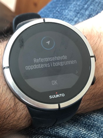
                  Never, but it say “in background” so … I never expected it 😁 but I noticed a blink in the watch face

                  SVTS - 2.40.38
                  SSSWHR BARO Amber - 2.8.32
                  Samsung A5 2016 - Android 7.0
                  Samsung A33 2022 - Android 14 - One UI 6.1
                  Suunto App Android 5.2.5 beta
                  Suunto App IOs 2.45.0 (19123) beta on MBP M1

                  1 Reply Last reply Reply Quote 0
                  • Stefan KerstingS Offline
                    Stefan Kersting @Dimitrios Kanellopoulos
                    last edited by

                    @Dimitrios-Kanellopoulos I get a gps position but after a manual calibration on 500 masl tja altitude isn’t adjusted when using auto calibration. Have to do it manually

                    Instagram: https://www.instagram.com/helgelandsbukken/
                    https://www.instagram.com/suunto_adventures/
                    IG: Helgelandsbukken, suunto_adventures
                    Vimeo: vimeo.com/helgelandsbukken
                    Blogg: https://turblogg.midnattsola.com

                    Dimitrios KanellopoulosD 1 Reply Last reply Reply Quote 0
                    • Dimitrios KanellopoulosD Offline
                      Dimitrios Kanellopoulos Community Manager @Stefan Kersting
                      last edited by

                      @Stefan-Kersting it needs up to 15 mins

                      Community Manager / Admin @Suunto
                      Creator of Quantified-Self.io
                      youtube.com/c/dimitrioskanellopoulos
                      https://instagram.com/dimitrioskanellopoulos
                      https://www.strava.com/athletes/7586105

                      Stefan KerstingS 1 Reply Last reply Reply Quote 0
                      • Stefan KerstingS Offline
                        Stefan Kersting @Dimitrios Kanellopoulos
                        last edited by

                        @Dimitrios-Kanellopoulos ok then I have to wait more than 2-3 minutes…

                        Instagram: https://www.instagram.com/helgelandsbukken/
                        https://www.instagram.com/suunto_adventures/
                        IG: Helgelandsbukken, suunto_adventures
                        Vimeo: vimeo.com/helgelandsbukken
                        Blogg: https://turblogg.midnattsola.com

                        1 Reply Last reply Reply Quote 0
                        • Stefan KerstingS Offline
                          Stefan Kersting @Brad_Olwin
                          last edited by

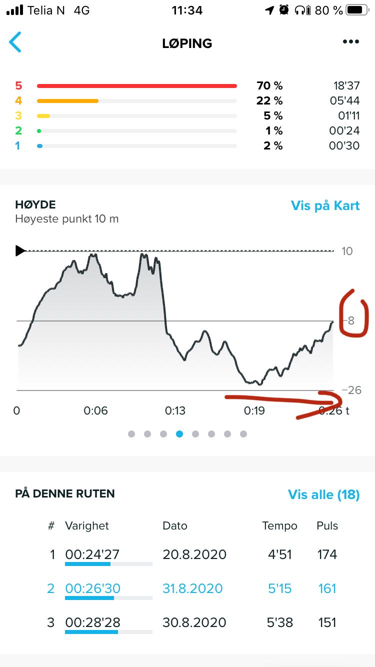
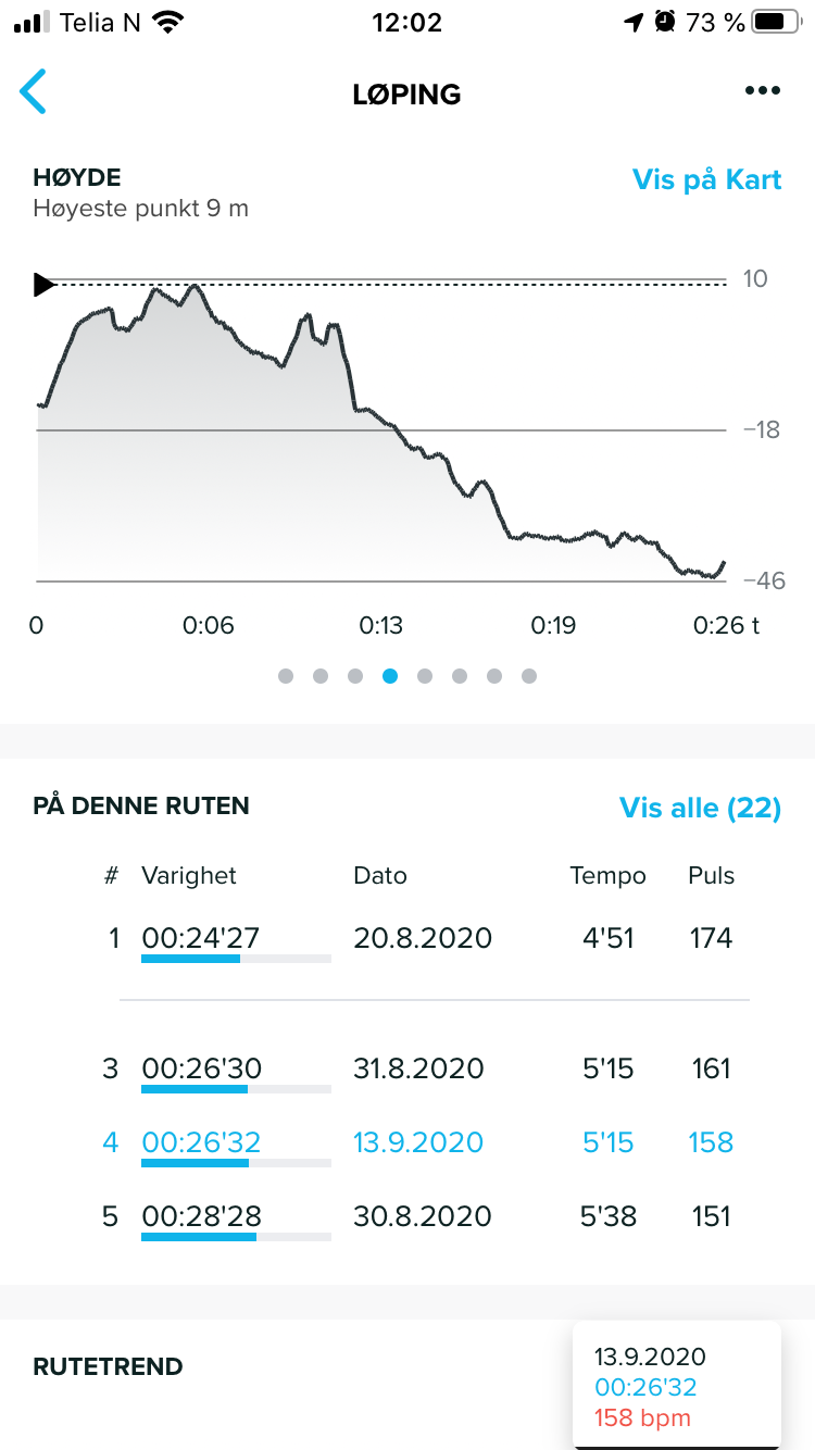
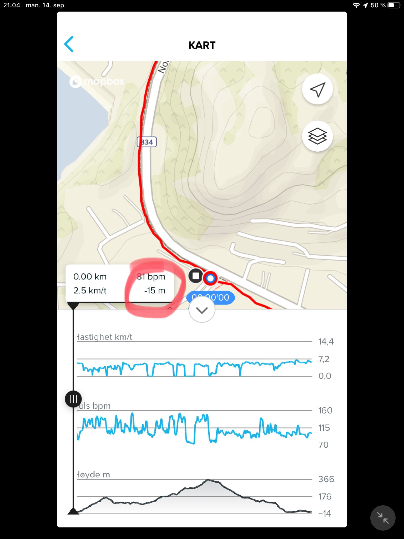
                          @Brad_Olwin now I did a hike and not a run in order to have enough time to follow the altitude on the watch. The interesting thing was that I started at an altitude of 5 masl and with a fast ascent to 30 masl and after a short time the altitude was at 13masl which was realistic. So that must be an issue with the satellite fix at the start. BUT I have never seen a negative altitude on the watch and when downloaded I see that the lowest point was registered with -15 below sea level. So now I don’t understand anything. The watch displays another altitude than SA…
                          E22434CC-2900-4F9D-B311-F9E538EC4368.jpeg

                          Instagram: https://www.instagram.com/helgelandsbukken/
                          https://www.instagram.com/suunto_adventures/
                          IG: Helgelandsbukken, suunto_adventures
                          Vimeo: vimeo.com/helgelandsbukken
                          Blogg: https://turblogg.midnattsola.com

                          1 Reply Last reply Reply Quote 0
                          • J Offline
                            johann.fuehrer Bronze Member
                            last edited by johann.fuehrer

                            Hello, I’m surprised that this “my altitude does not match with my map reading” topic is coming up ever and ever again. I have written about this somewhere in the past, so here some information from guys who know what it is about: https://www.usgs.gov/faqs/why-dont-elevations-your-maps-agree-those-provided-my-gps-system-which-ones-are-correct?qt-news_science_products=0#qt-news_science_products

                            This is one of the reasons, Garmin brought in DEM data to Fenix models (I think mesh points in 30m grid)…

                            That is why I suggested a local offset which CAN be set manually and would shift the GPS altitude calculated by this offset for EVREY altitude value - right ones and wrong ones (bad GPS, abro i.e.). So also fused alti would work. It would not touch the GPS altitude reading and calculation directly, but after getting GPS altitude + fused alti calculations, it would add/sub the local offset of the GPS_geoid_to_real_map_alti difference which has been set manually. my5c

                            (which would mean: exact the same altitude profile but shiftet to real altitude due to offset…)

                            Fenr1rF Dimitrios KanellopoulosD 2 Replies Last reply Reply Quote 0
                            • Fenr1rF Offline
                              Fenr1r @johann.fuehrer
                              last edited by Fenr1r

                              @johann-fuehrer said in Issues altitude diagram:

                              TruFusedAlti. Do we know if Suunto uses the datum elevation or that from satellite triangulation? Or one and then the other?

                              my5c

                              Inflation?

                              J 1 Reply Last reply Reply Quote 0
                              • Dimitrios KanellopoulosD Offline
                                Dimitrios Kanellopoulos Community Manager @johann.fuehrer
                                last edited by

                                @johann-fuehrer afaik Suunto uses mean sea level. What am I missing ?

                                Community Manager / Admin @Suunto
                                Creator of Quantified-Self.io
                                youtube.com/c/dimitrioskanellopoulos
                                https://instagram.com/dimitrioskanellopoulos
                                https://www.strava.com/athletes/7586105

                                J 1 Reply Last reply Reply Quote 0
                                • J Offline
                                  johann.fuehrer Bronze Member @Fenr1r
                                  last edited by

                                  @Fenr1r said in Issues altitude diagram:

                                  @johann-fuehrer said in Issues altitude diagram:

                                  TruFusedAlti. Do we know if Suunto uses the datum elevation or that from satellite triangulation? Or one and then the other?

                                  Dont know. BTW: This was the thread & post I referred to, needed some time to find it again 😉 … https://forum.suunto.com/post/36919

                                  Fenr1rF 1 Reply Last reply Reply Quote 0
                                  • Fenr1rF Offline
                                    Fenr1r @johann.fuehrer
                                    last edited by

                                    @johann-fuehrer Thank you. Very interesting and now my head hurts.

                                    J 1 Reply Last reply Reply Quote 0
                                    • J Offline
                                      johann.fuehrer Bronze Member @Dimitrios Kanellopoulos
                                      last edited by

                                      @Dimitrios-Kanellopoulos said in Issues altitude diagram:

                                      @johann-fuehrer afaik Suunto uses mean sea level. What am I missing ?

                                      The physical model of Earth and the mathematical model of GPS geoid do not match. Not in altitude (and also not in horizontal offsets, but let’s forget this by now). Maps are not based on the GPS geoid but of some agreed MSL - but not to the same over the whole world (https://en.wikipedia.org/wiki/Vertical_datum)
                                      There is lot of stuff about this on the internet, and to what funny results this led like tunnes planned by two different countries which did not met, bridges and other stuff. But the main conclusion is: GPS watches calculate the altitude based on a “ideal” world shape, which does not 100% match. For some parts of the world the altitude calculated match perfect, on others it’s way off (there is some map about the offset here: https://www.esri.com/news/arcuser/0703/geoid1of3.html) . DEM models have correction information based on the location for the GPS calculated values.

                                      So for places on earth where the GPS and map data have a “natual” offset, you need an additional correction, if you want to be precise - or live with the altitude profile being OK but have a small or bigger offset.

                                      Dimitrios KanellopoulosD 1 Reply Last reply Reply Quote 1
                                      • J Offline
                                        johann.fuehrer Bronze Member @Fenr1r
                                        last edited by

                                        @Fenr1r said in Issues altitude diagram:

                                        @johann-fuehrer Thank you. Very interesting and now my head hurts.

                                        I’m sorry for your headaches…

                                        Dimitrios KanellopoulosD Fenr1rF 2 Replies Last reply Reply Quote 0
                                        • Dimitrios KanellopoulosD Offline
                                          Dimitrios Kanellopoulos Community Manager @johann.fuehrer
                                          last edited by

                                          @johann-fuehrer I have a headache as well 🙂

                                          Community Manager / Admin @Suunto
                                          Creator of Quantified-Self.io
                                          youtube.com/c/dimitrioskanellopoulos
                                          https://instagram.com/dimitrioskanellopoulos
                                          https://www.strava.com/athletes/7586105

                                          J 1 Reply Last reply Reply Quote 0
                                          • Dimitrios KanellopoulosD Offline
                                            Dimitrios Kanellopoulos Community Manager @johann.fuehrer
                                            last edited by

                                            @johann-fuehrer at the same time I hear / read in other groups of garmin that the DEM is not ok. Am I wrong 😞 ? I am asking not to downplay Garmin, I love DEM, but I want to know in practice. At least if it solves issues like @johann-fuehrer has or even @Stefan-Kersting

                                            Community Manager / Admin @Suunto
                                            Creator of Quantified-Self.io
                                            youtube.com/c/dimitrioskanellopoulos
                                            https://instagram.com/dimitrioskanellopoulos
                                            https://www.strava.com/athletes/7586105

                                            J 1 Reply Last reply Reply Quote 0
                                            • First post
                                              Last post

                                            Suunto Terms | Privacy Policy