Suunto app Forum Suunto Community Forum
    • Recent
    • Tags
    • Popular
    • Users
    • Groups
    • Register
    • Login

    SA: route planner

    Scheduled Pinned Locked Moved Suunto app - Questions & Feedback
    34 Posts 11 Posters 1.8k Views 11 Watching
    Loading More Posts
    • Oldest to Newest
    • Newest to Oldest
    • Most Votes
    Reply
    • Reply as topic
    Log in to reply
    This topic has been deleted. Only users with topic management privileges can see it.
    • Mitch9M Offline
      Mitch9 @Guest
      last edited by

      @gi0vanni Where is this path? Tell us, so we can check it.

      I changed some feutures in OSM because it was wrong mapped and not routable in SA.

      Watch: Suunto Vertical Titanium Solar (Sand)
      SA: Android (beta)
      HRS: Polar H10

      ? 1 Reply Last reply Reply Quote 0
      • isaziI Online
        isazi Moderator @Guest
        last edited by

        @gi0vanni highway=path may not be enough, depending on other metadata of the track

        Watch: Suunto Vertical Ti

        Blog: isazi's home

        1 Reply Last reply Reply Quote 0
        • ? Offline
          A Former User @Mitch9
          last edited by

          @Mitch9 said in SA: route planner:

          Where is this path?

          Mitch9M 1 Reply Last reply Reply Quote 0
          • Mitch9M Offline
            Mitch9 @Guest
            last edited by

            @gi0vanni I think the problem is this:

            Path

            sac_scale: unknown

            Watch: Suunto Vertical Titanium Solar (Sand)
            SA: Android (beta)
            HRS: Polar H10

            ? 1 Reply Last reply Reply Quote 1
            • sartoricS Offline
              sartoric Moderator
              last edited by sartoric

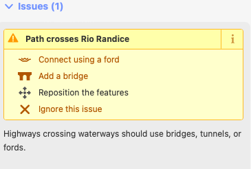
              I guess the problem is very probably the river crossing 🙂

              Schermata 2023-08-02 alle 16.47.08.png

              SVTS - 2.40.38
              SSSWHR BARO Amber - 2.8.32
              Samsung A5 2016 - Android 7.0
              Samsung A33 2022 - Android 14 - One UI 6.1
              Suunto App Android 5.2.5 beta
              Suunto App IOs 2.45.0 (19123) beta on MBP M1

              1 Reply Last reply Reply Quote 0
              • ? Offline
                A Former User @Mitch9
                last edited by A Former User

                @Mitch9 said in SA: route planner:

                @gi0vanni I think the problem is this:

                Path

                sac_scale: unknown

                So the SA planner always avoids paths where key sac_scale is unknown?

                1 Reply Last reply Reply Quote 0
                • D Offline
                  dombo Bronze Member
                  last edited by

                  different, but related to SA planner. It makes me crazy planning route for road biking, where it:

                  • does not follow straight road and use non logical shortcuts
                  • prioritize cycling paths (even sidewalks) over the road

                  so in order to use tbt I have to manually adding planning points to avoid using of shortcuts, what is really pita.

                  MiniForkliftM 1 Reply Last reply Reply Quote 1
                  • MiniForkliftM Offline
                    MiniForklift Platinum Member @dombo
                    last edited by

                    @dombo said in SA: route planner:

                    It makes me crazy planning route for road biking, where it:

                    • does not follow straight road and use non logical shortcuts
                    • prioritize cycling paths (even sidewalks) over the road

                    so in order to use tbt I have to manually adding planning points to avoid using of shortcuts, what is really pita.

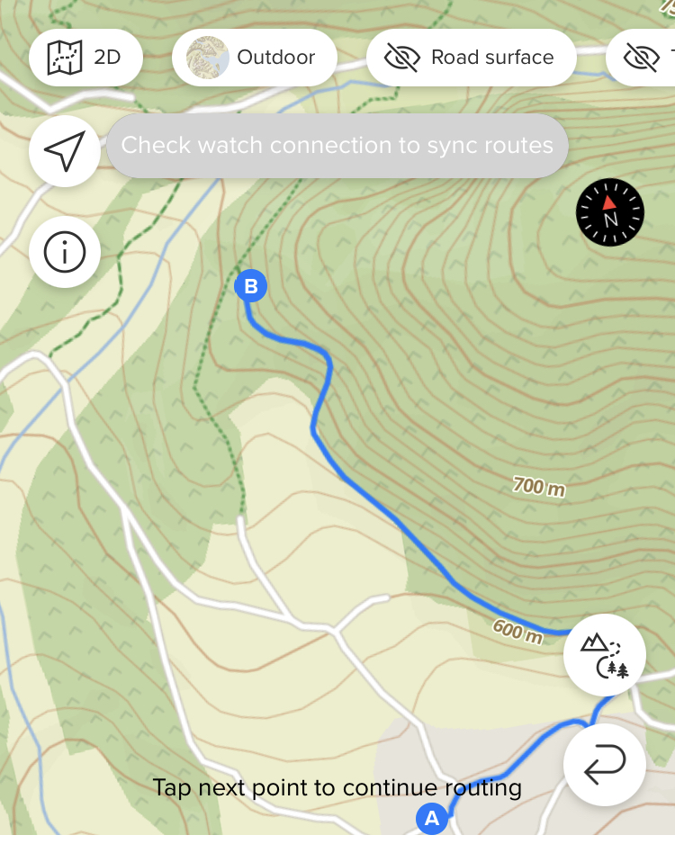
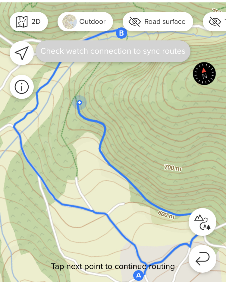
                    Yeah, I agree that it’s a PITA although I think I have just gotten used to it now. Often I’ll have to plot 3 or 4 smaller points/segments along what is essentially a straight road because the SA map sends me off all over the place it I try to go from a simple A to B point. Sometimes I can get around this a little bit by changing the road surface, for example setting it to paved roads for road cycling but a lot of the time it’s like it wants to pick the craziest routing to get to where I want to get to; I’ll often have to change this a few times if I am mapping out a larger route. Instead of having a small number of points plotted I end up having to drop in lots just so I can map the actual route I would like to travel. Here’s one as an example, case in point 😳

                    IMG-3710.jpg

                    SV Titanium Solar Forest

                    1 Reply Last reply Reply Quote 0
                    • MdzOttM Offline
                      MdzOtt
                      last edited by

                      There are some unroutable segments out there and this has nothing to do with difficulty or danger. Some places in OpenStreet Map just can’t get routed through. There is a bike/pedestrian bridge over a highway where i live (and ride) and you just can’t do a route through it. I tried to check the OpenStreet map and edit it, but that segment has the correct attributes. Btw. it does not work for creating routes in SA, but also in Strava.

                      S9 Baro
                      SA on Android
                      Ambit 3 Peak
                      Ambit 2 Sapphire

                      1 Reply Last reply Reply Quote 1
                      • T Offline
                        trailcafe Bronze Member
                        last edited by

                        plotaroute.com is also based on OSM maps and routes anything without issues. Same for the Footpath app. Can someone explain, why there are differences in routing? For me it seems, that SA fails and the others can manage route creation in a better way. But I cannot explain it to me why this is the case.

                        f5cf89d4-0342-4ab8-99e6-d8b0f5f27cba-image.png

                        ? Mff73M 2 Replies Last reply Reply Quote 0
                        • ? Offline
                          A Former User @trailcafe
                          last edited by

                          @trailcafe Indeed! yesterday i took some time to plan well known routes with SA and twice i ran into the same problem. komoot however worked without any problems. it is a pity for SA, just hope they will address this issue in the future

                          1 Reply Last reply Reply Quote 0
                          • Mff73M Offline
                            Mff73 @trailcafe
                            last edited by Mff73

                            @trailcafe
                            OSM is the source of data : points, path, tracks, etc… are created there, with attributes.
                            Then, there are map generations using these source of data, and each map generator (OSM itself for itself, or mapbox for others, or openandromap, etc…) are taking attributes and filter, tweak, to display the way they want/can.
                            Then it comes to routing, where same OSM data source is used by routing engines to follow what can be followed using routing profiles (sometimes one can see routed path on a “path” not displayed on the map itself 😉 )

                            Something in OSM not routable “at all”, and no routing engine will go through this.
                            But something routable, according to some profile criteria can be walked through but not cycle, etc…, and finally (maybe not complete explanation, just my own understanding) which optimisation or path choosing when multiple are possible, it is the magic inside each routing profiles/engines i think.

                            Then SA/Komoot/etc use all OSM raw data, have potentially their own mapping “provider”/“sources”, and also their “own” routing engine/profiles.

                            It may just explain the differences, not why SA is not the best at routing (according to users).

                            Suunto Spartan Ultra (since 2016) FW: 2.8.24 (retired)
                            Suunto Vertical all black
                            Wife : S9PP
                            SA: Always the latest beta :)
                            Android 13, Galaxy S205G

                            T 1 Reply Last reply Reply Quote 1
                            • T Offline
                              trailcafe Bronze Member @Mff73
                              last edited by

                              @Mff73 thank you very much. When I get it right, SA could improve its mapping because it’s using “its own” routing engine that could be tweaked to e.g. route all visible paths (or any other criteria).

                              isaziI 1 Reply Last reply Reply Quote 0
                              • isaziI Online
                                isazi Moderator @trailcafe
                                last edited by

                                @trailcafe not sure Suunto App is using its own routing, I believe they use the mapbox API.

                                Watch: Suunto Vertical Ti

                                Blog: isazi's home

                                1 Reply Last reply Reply Quote 1
                                • T Offline
                                  trailcafe Bronze Member
                                  last edited by

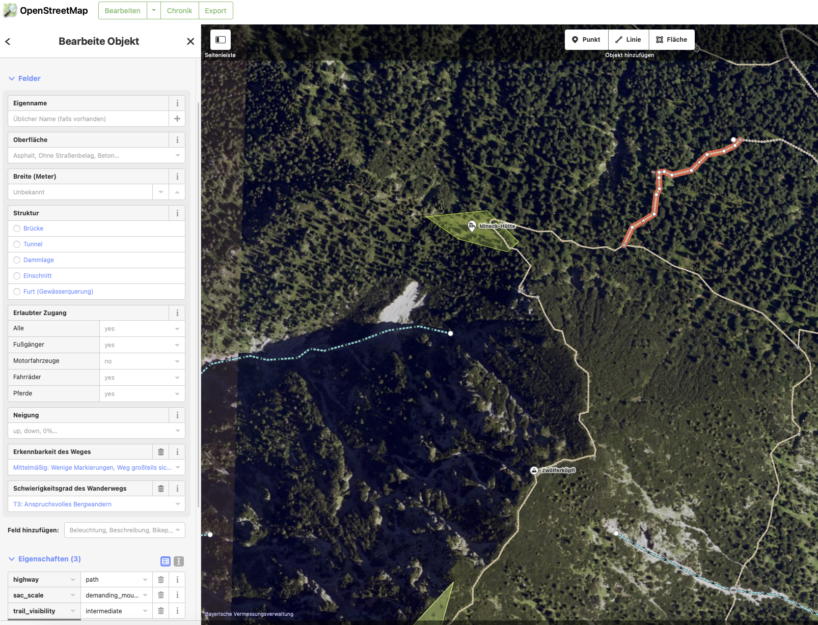
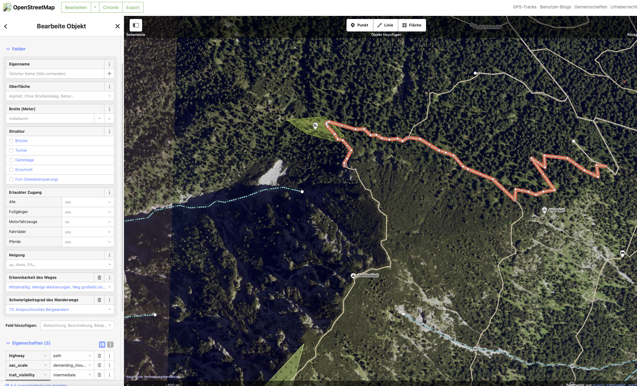
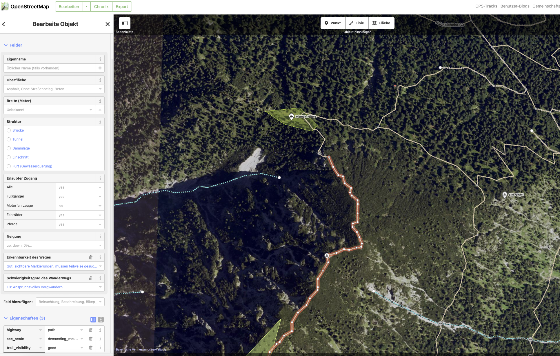
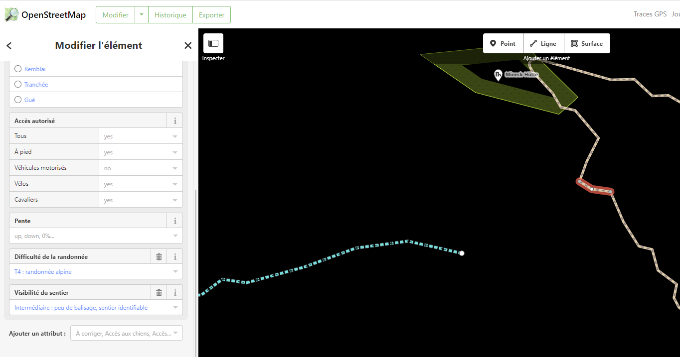
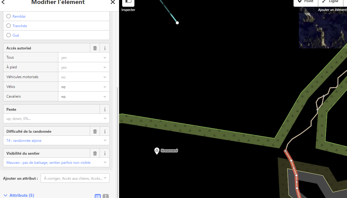
                                  I just went into OSM and checked the metadata of some paths:

                                  1. and 2. picture is correctly routed by SA, 3. picture shows the path that SA ignores. I can’t see any differences in classification
                                    Link to area: https://www.openstreetmap.org/edit?editor=id#map=17/47.57343/11.21559

                                  Bildschirmfoto 2023-08-03 um 09.48.31.png

                                  Bildschirmfoto 2023-08-03 um 09.49.38.png

                                  Bildschirmfoto 2023-08-03 um 09.49.49.png

                                  The Mapbox API does not have any high sophisticated settings
                                  b765a7c4-dcce-4203-ada2-7da01a7cbdbd-image.png
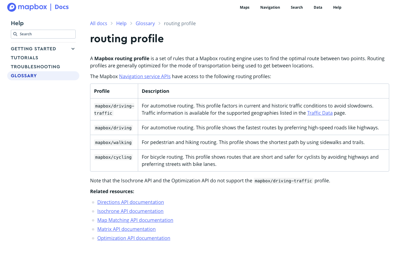
                                  https://docs.mapbox.com/api/navigation/directions/

                                  Mff73M 1 Reply Last reply Reply Quote 0
                                  • Mff73M Offline
                                    Mff73 @trailcafe
                                    last edited by

                                    @trailcafe
                                    Sometimes it is not the path itself which is faulty, but its non proper connexion with other paths. Just one point not linked and the path, properly setup, is a dead-end, and routing will avoid it.

                                    Suunto Spartan Ultra (since 2016) FW: 2.8.24 (retired)
                                    Suunto Vertical all black
                                    Wife : S9PP
                                    SA: Always the latest beta :)
                                    Android 13, Galaxy S205G

                                    T 1 Reply Last reply Reply Quote 0
                                    • T Offline
                                      trailcafe Bronze Member @Mff73
                                      last edited by

                                      @Mff73 Yes, and that is also understandable. But that does not apply here in this example.

                                      Mff73M 1 Reply Last reply Reply Quote 0
                                      • Mff73M Offline
                                        Mff73 @trailcafe
                                        last edited by

                                        @trailcafe
                                        strange, yes.
                                        This path 3 is routable in other tools (with locus and brouter)

                                        Just one thinking : this path 3 is connected to its both end to a path which is quoted “alpine hiking”
                                        here
                                        effee32f-db83-487f-b12e-463ecea8fa45-image.png

                                        and here
                                        bde8d0a3-c0a6-4534-8d01-7878863736d2-image.png

                                        so, if SA refuse to route Alpine Hiking paths (hypothesis), then this path 3 is never reachable in SA routing.
                                        But indeed little strange 🤔

                                        Suunto Spartan Ultra (since 2016) FW: 2.8.24 (retired)
                                        Suunto Vertical all black
                                        Wife : S9PP
                                        SA: Always the latest beta :)
                                        Android 13, Galaxy S205G

                                        T 1 Reply Last reply Reply Quote 1
                                        • T Offline
                                          trailcafe Bronze Member @Mff73
                                          last edited by

                                          @Mff73 Damn, I’ve overseen that little part. Changed it to T3 which is still ok for classification. Environment changed and it got easier in this small part.

                                          1 Reply Last reply Reply Quote 0
                                          • First post
                                            Last post

                                          Suunto Terms | Privacy Policy