Suunto app Forum Suunto Community Forum
    • Recent
    • Tags
    • Popular
    • Users
    • Groups
    • Register
    • Login

    Doubt about Suunto 9 Baro altimeter/barometer calibration

    Scheduled Pinned Locked Moved Suunto app - Questions & Feedback
    104 Posts 14 Posters 7.9k Views 17 Watching
    Loading More Posts
    • Oldest to Newest
    • Newest to Oldest
    • Most Votes
    Reply
    • Reply as topic
    Log in to reply
    This topic has been deleted. Only users with topic management privileges can see it.
    • freeheelerF Offline
      freeheeler @johann.fuehrer
      last edited by

      @johann-fuehrer
      yes, almost new watch and I am aware of the baro holes issue from my earlier Suunto Core…
      The activities before and after were recorded without any issue, like I am used to.
      I am pretty sure I confused fused alti with manual setting while “climbing” in the gondola and then immediately starting the activity.

      living sideways

      freeheelerF 1 Reply Last reply Reply Quote 0
      • freeheelerF Offline
        freeheeler @freeheeler
        last edited by

        @TELE-HO
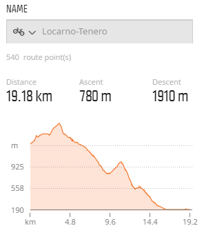
        this is roughly the graph of the route when I draw it in MC map.
        3d257358-7ea5-496c-b5e2-805b5a39a45b-image.png

        living sideways

        mario_bM J 2 Replies Last reply Reply Quote 0
        • mario_bM Offline
          mario_b @freeheeler
          last edited by

          @TELE-HO AFAIK if you manually calibrate the altitude while recording an activity, fused-alti will be disabled. not if you calibrate it before an activity. would be nice to see this activity in MC 🙂 because allways when fused-alti calibrates the altitude for more then around 8 meters, you see the pressure change in the baro diagram.

          freeheelerF 1 Reply Last reply Reply Quote 0
          • J Offline
            johann.fuehrer Bronze Member @freeheeler
            last edited by johann.fuehrer

            @TELE-HO Is it possible for you to merge this one and the recorded one in to one graph? Maybe quantified.io is helpful? I did nor use it yet, but have seen a lot of such stuff is done in there by others…

            Dimitrios KanellopoulosD 1 Reply Last reply Reply Quote 0
            • Dimitrios KanellopoulosD Offline
              Dimitrios Kanellopoulos Community Manager @johann.fuehrer
              last edited by

              @johann-fuehrer Jup that is possible

              Community Manager / Admin @Suunto
              Creator of Quantified-Self.io
              youtube.com/c/dimitrioskanellopoulos
              https://instagram.com/dimitrioskanellopoulos
              https://www.strava.com/athletes/7586105

              1 Reply Last reply Reply Quote 0
              • freeheelerF Offline
                freeheeler @mario_b
                last edited by

                @mario_b
                yes I am aware that you switch off fused alti when manual calibrating during an activity recording.
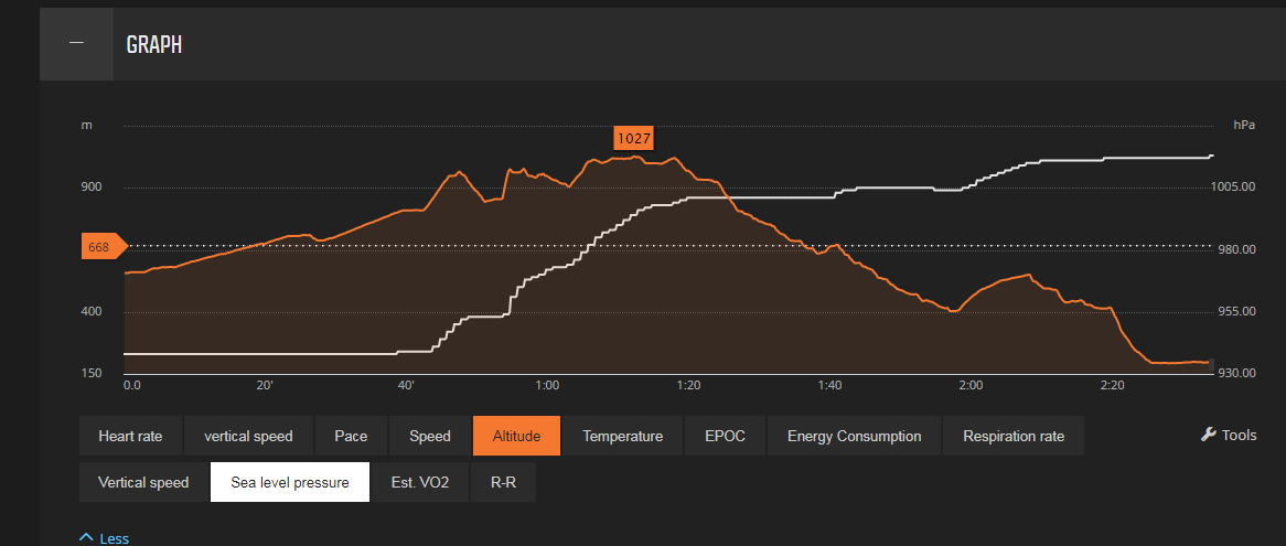
                Here’s the sea level pressure with the altitude profile.

                @Dimitrios-Kanellopoulos
                I don’t know who to do an overlay… but if I do an overlay, it would be necessary to have it almost idential from the drawn to the recorded track to have the best comparison, right?
                6414a92e-187c-478b-9d3c-00e2324642f5-image.png

                living sideways

                Dimitrios KanellopoulosD J mario_bM 3 Replies Last reply Reply Quote 0
                • Dimitrios KanellopoulosD Offline
                  Dimitrios Kanellopoulos Community Manager @freeheeler
                  last edited by

                  @TELE-HO update 2 activiteis / routes to QS.
                  Select them on the table
                  Press merge
                  Use the distance axis when viewing

                  Community Manager / Admin @Suunto
                  Creator of Quantified-Self.io
                  youtube.com/c/dimitrioskanellopoulos
                  https://instagram.com/dimitrioskanellopoulos
                  https://www.strava.com/athletes/7586105

                  1 Reply Last reply Reply Quote 0
                  • J Offline
                    johann.fuehrer Bronze Member @freeheeler
                    last edited by

                    @TELE-HO for a GPX track you can get “real” altitude information here i.e. https://www.gpsvisualizer.com/elevation but I do not know how exact that is…

                    J 1 Reply Last reply Reply Quote 0
                    • J Offline
                      johann.fuehrer Bronze Member @johann.fuehrer
                      last edited by

                      @johann-fuehrer … it’s a 30m x 30m grid SRTM1

                      1 Reply Last reply Reply Quote 0
                      • Dimitrios KanellopoulosD Offline
                        Dimitrios Kanellopoulos Community Manager
                        last edited by

                        Runanalyze!

                        Screenshot 2019-08-19 at 15.13.47.png

                        Community Manager / Admin @Suunto
                        Creator of Quantified-Self.io
                        youtube.com/c/dimitrioskanellopoulos
                        https://instagram.com/dimitrioskanellopoulos
                        https://www.strava.com/athletes/7586105

                        1 Reply Last reply Reply Quote 1
                        • mario_bM Offline
                          mario_b @freeheeler
                          last edited by

                          @TELE-HO perfect. i think you’ve being right, as you said, that i could be, because you calibrated it on the gondola.
                          as you can see, fused-alti is correcting the altitude all the time on the activity to a higher altitude. is the altitude value on the end of the activity nearly correct?

                          freeheelerF 1 Reply Last reply Reply Quote 0
                          • freeheelerF Offline
                            freeheeler @mario_b
                            last edited by

                            @mario_b
                            yes, it is absolutely correct at the end.

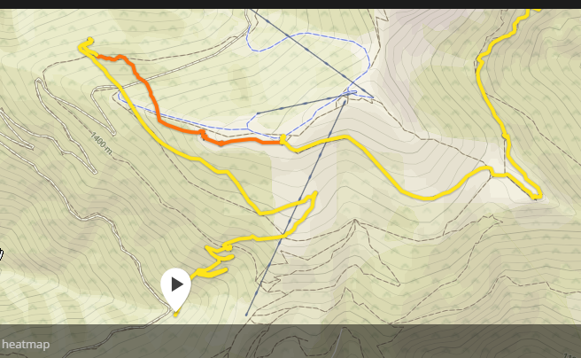
                            I just noticed that I’ve had a GPS precision issue for the first 35minutes of this activity anyway. I wanted to redraw the exact route but saw that the signal was off track at the beginning… it does not make sense to overlay my recorded move with a drawn route I think.
                            c02a811e-6f7e-4a16-9ca7-9966aefad5ea-image.png

                            living sideways

                            mario_bM 1 Reply Last reply Reply Quote 0
                            • mario_bM Offline
                              mario_b @freeheeler
                              last edited by

                              @TELE-HO so i would say, there is nothing wrong with your watch. looking at the ambient pressure at around 930 (which is not anough for the swiss the last weekend) i think it was only a faulty calibration at start. then fused alti kicked in, and corrected the altitude until it was nearly correct. (>1005 hpa at the end sound more possible too). 🙂 👍

                              J 1 Reply Last reply Reply Quote 1
                              • J Offline
                                johann.fuehrer Bronze Member @mario_b
                                last edited by johann.fuehrer

                                @mario_b same opinion. Somewhere at 1 h 15 mins after start it started to look ok.

                                1 Reply Last reply Reply Quote 0
                                • ? Offline
                                  A Former User @Dimitrios Kanellopoulos
                                  last edited by

                                  @Dimitrios-Kanellopoulos Thanks 👍 . Again, sounds logic.
                                  After my test that I described below I have this doubt: you know with which frequency the S9B take samples of the barometer to calculate and show the altitude? or which is the frequency that update the altitude displayed?

                                  I made a simple test using the S9B, Mobile with barometer and Samsung Gear Frontier. I went downstairs one floor (~4m difference).

                                  1st try: S9B not show differences even after ~20sec or a bit more. Mobile and Gear displays the -4m variation instantly, the altitude on these both devices is continuing updating almost on each step that I do down.
                                  I went up. Mobile and Gear displays the variation of +4m. S9B again no differences. After around 5 minutes, I see that the S9B display me a -4m difference (wrong), looks like displays me the value from when I was down, but do not register that I went up again.

                                  2nd try: Mobile & Gear again displays correct results instantly and continuously. S9B: I decide give more time waiting on each floor. After few seconds or minute waiting on the lower floor, start to display me a variation of -3m, after few minutes I get the -4m. I went up again, +4m after few seconds or almost a minute.

                                  Results: Mobile & Gear displayed correct value all the times and instantly. S9B worked tricky. One time showed me a correct result but maintained the difference error created on 1st try. 2nd try was perfect, but need sometime to show me the correct values.

                                  J mario_bM 2 Replies Last reply Reply Quote 0
                                  • J Offline
                                    johann.fuehrer Bronze Member @Guest
                                    last edited by

                                    @flypg I have read about some threshold value which must be reached until an altitude change is recognized by the watch, I think it was about 3m or somewhere in that range. Maybe this kicks in as well …

                                    ? 1 Reply Last reply Reply Quote 0
                                    • ? Offline
                                      A Former User @johann.fuehrer
                                      last edited by

                                      @johann-fuehrer Thanks, yes, this is why I would like know with precision to understand a bit more the watch. I think that also exist some timelapse to process this or display this and this results in the “delay” that I see to display the information.

                                      1 Reply Last reply Reply Quote 0
                                      • mario_bM Offline
                                        mario_b @Guest
                                        last edited by

                                        @flypg if it’s the same algorythm that is used in the ambit3 peak for automatic mode then:
                                        When in watch mode, it messures every 10 sec. if you move up/down more then 5 meters in elevation (around 0,6hpa) in 3 minutes, it switches to alti-mode. when your are moving less then 5 meters in 12 minutes the watch switches back to baro-mode

                                        ? 1 Reply Last reply Reply Quote 1
                                        • ? Offline
                                          A Former User @mario_b
                                          last edited by A Former User

                                          Thanks @mario_b! Now I can understand for what on 1st try the reaction not was immediately and I got better results on 2nd try.

                                          it messures every 10 sec

                                          Wow, I imagined that should be a lower value, by this I expected a faster response in the update of the altitude readings. But really not need a faster update in watch mode, because for this I have the Sport Modes.
                                          Thanks to everyone again!

                                          Dimitrios KanellopoulosD 1 Reply Last reply Reply Quote 1
                                          • Dimitrios KanellopoulosD Offline
                                            Dimitrios Kanellopoulos Community Manager @Guest
                                            last edited by

                                            @flypg it counts higher than 3-5m variations in 12 minutes. If you would go a bit more low then both devices should react the same.

                                            That is to wipe out pressure changes as we talked before

                                            Community Manager / Admin @Suunto
                                            Creator of Quantified-Self.io
                                            youtube.com/c/dimitrioskanellopoulos
                                            https://instagram.com/dimitrioskanellopoulos
                                            https://www.strava.com/athletes/7586105

                                            1 Reply Last reply Reply Quote 0
                                            • First post
                                              Last post

                                            Suunto Terms | Privacy Policy