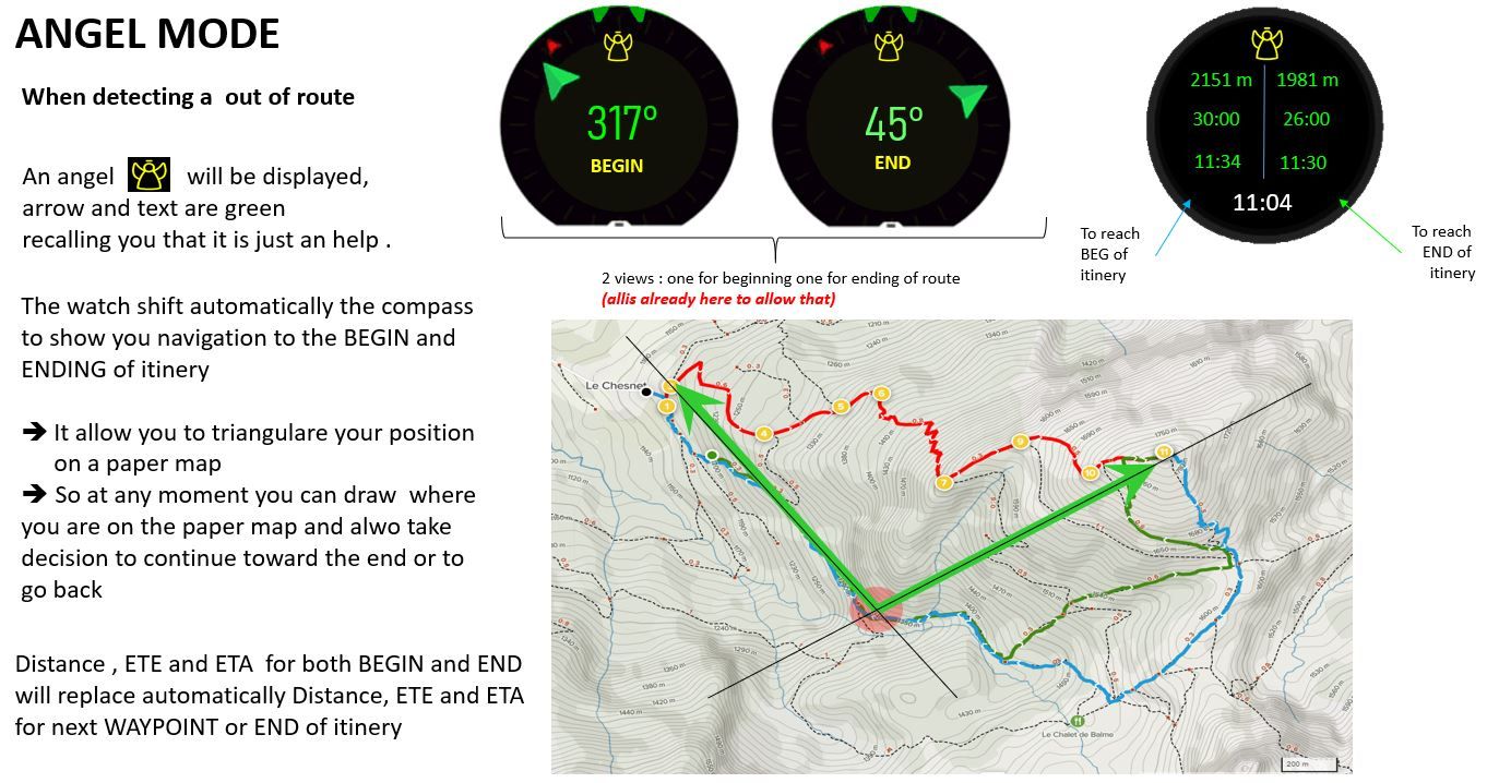
ANGEL MODE... When your watch detect you are lost and are out of route
-
Hello dmytro
For sure better than nothing is always good.
You know I’m just suggesting ideas, I have no super power to strongly say “I WANT THIS LIKE THAT !!!”

if tomorrow the S+ can be selected in middle of the exercise then it is a very good alternative.
So let’s revisit it in that angle and it could become like this
- the S+ option could be selected in the middle of an exercise
- we have now the possibility to add COMPASS when we personalize the exercise screens
2 possibilities here :
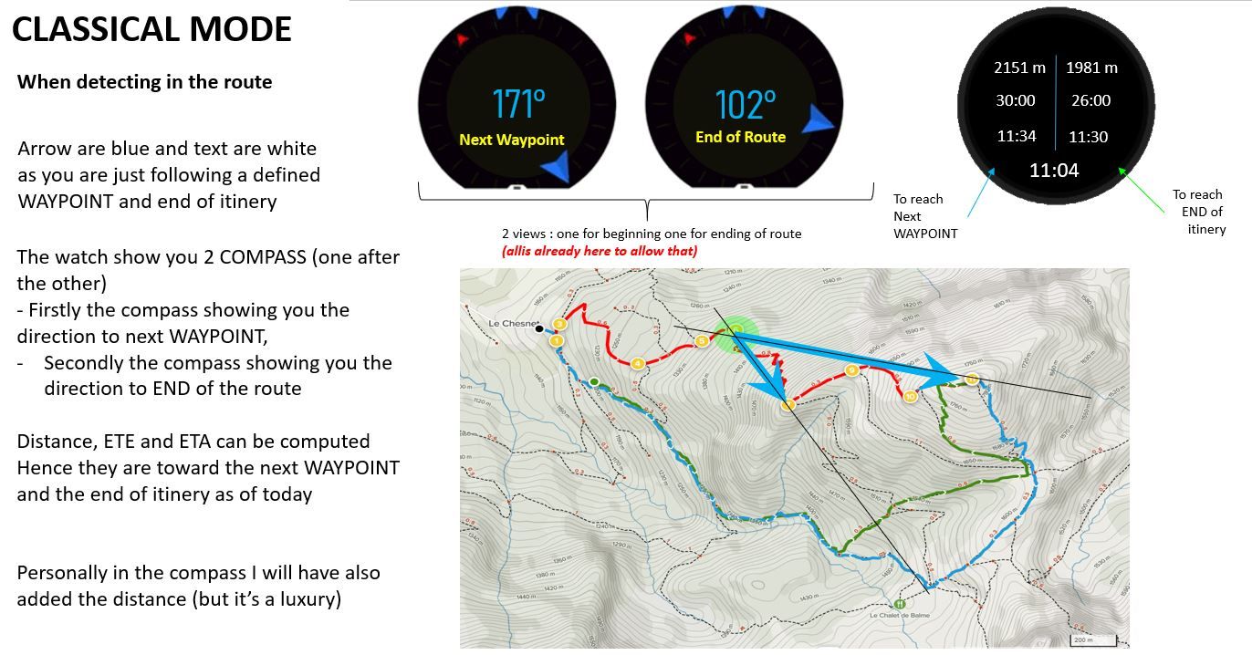
- either we have a new COMPASS with 2 arrows, in such case we just need to add one
- or no change on COMPASS, in that case will be great if in the exercise view we can add 2 compass (one for POI one for END of itinery)
- When we need the ANGEL mode, then we can call this S+ in the middle of the exercise and it will activate it
Going that way … there is already a S+ SAFE mode, so … may be … it could be this mode that will add the ANGEL possibilities if we select it …
it will add the S+ SAFE screen as today and automatically switch the bearing navigations from POI/newt waypoint/End itinery to BEG and END of itinery …May be a good idea.
Another suggestion
=> I wil write a small post on it : what about if there is a new navigation OPTION = Navigate to one of the course waypoints and which allow us to select a course (or if we are inside a course already then propose naturally its waypoints) and we can select 1) the BEG, 2) the END … then … eventually … the others sorted by the route
-
@mister-pyc this sounds over-engineered
-

I may agree with you .
I was thinking to another alternative which is far simplier .
Today we have
- navigate to a POI
- navigate on a Route
- bearing navigation
What about if we have one more possibility
- navigate to a route’s waypoint … could be call simply navigate to a waypoint
This new possibility working as follow :
When you select it, it display you the possible routes loaded on you watch and then a new screen allowing you to select one of the waypoint.
It just requires to
- have the COMPASS always available during an excercise, in any case for me this is a big miss currently. we should see the compass and in case we are navigating it should indicate the bearing informations
- develop a new screen to allow to select a waypoint of a route to navigate to
There are plenty advantages here
- such navigation can be done without stopping the exercise, which is very good
- it allow in case you start bad since the beginning, but are not too far from your forecasted route, to reach this forecasted BEGIN point
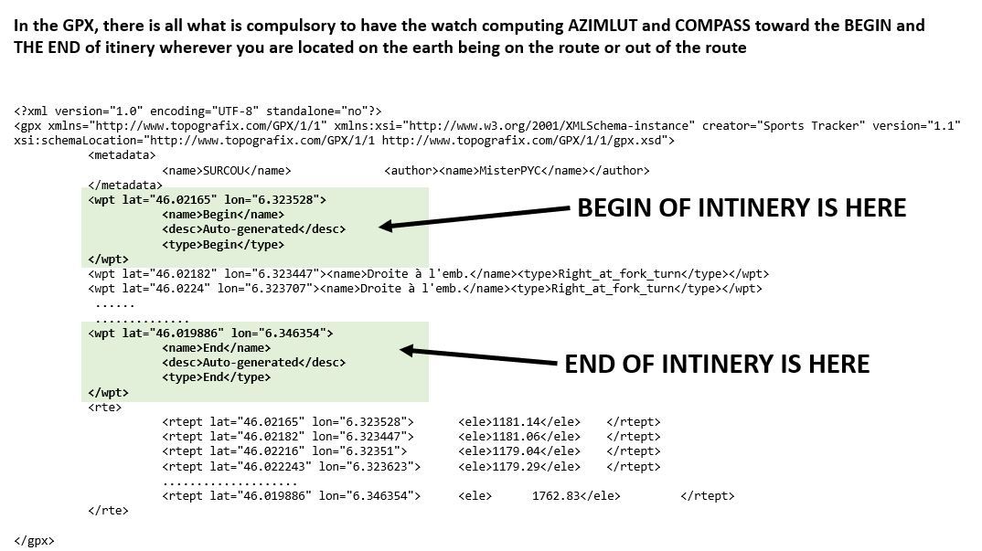
- It allow in case you are really out of route to point now the END of the route even if you were not storing it as a POI (you can be sure you forgot to do this at home
 ) … so at least instead of ZERO info you have some indication on how far you are from the end in a direct walk (better that the today nothing)
 - if really you have the feeling to be lost … you can successivelly point the BEGIN, put the angle on the paper map, then point the END, put also the angle on the map … so you report you position on the map …
- last but not least you can use this feature as a trick … you now have a notion of library !!! so … for example … if you create a route in which you store as waypoint some interresting POI, it might not be the super good route to navigate but you have stored all the interrestign waypoints of that area into a single gpx (the first being the parking or starting refuge, the last being either the summit or the targetted refuge, and in the middle you can place some interresting places or summit you want to go …
What do you think …
We do not take advantage of this automatic switching of ANGEL mode, it take more effort to do a triangulation that was coming naturally with the ANGEL mode … but … may be it is simplier do develop … well … I do not think what I was proposing was such difficult to develop …
If there was a way to develop some POC by ourselves I will have been happy to participate here actively …

-
Hello Dimitrios.
taking your rq of over enigneering and one more time playing with my dogs … the best moment to try and think to the suunto

what about even simplier :
-
Have the possibility to add the COMPASS screen in personalized view
this for sure is a missing feature -
when you are on the compass view there is a contextual menu if we press a long time on the central button … why not to take benefit of it as follow :
When the user opened the contextual menu he will have new choices in case a route was selected :
- Navigate to the route’s start (first GPX waypoint)
- Navigate to the rout’s end (last GPX waypoint)
- Navigate again on the route (back as of today)
Doing so … no need even to add complex screens
For sure … if one day there will be 2 arrows on the COMPASS (not counting the north), then it could have been great to have one more navigation option
- Show route’s start and begin which will allow triangulation and safe positioning on paper map even in darkness , cloud or white day.
PS 1 : I think I’m done now with all the details of my suggestion …
PS 2 : we are now 3 to wait for an enhanced freesbe mode …although we are just a few meters from the house so not sure the angel mode will be necessary here


-
-
@mister-pyc said in ANGEL MODE... When your watch detect you are lost and are out of route:
Have the possibility to add the COMPASS screen in personalized view
this for sure is a missing featureyou have the north to the navigation screen actually.
I am not the one deciding on this but to me it sounds well complicated for using a sports watch, not even sure what user percentage would be using this.
Not that I am saying that this is not a good suggestion
-
@mister-pyc well i don’t have compas in S5 so i can’t judge this suggestion. But in excercise you can always enable navigation screen breadcrumbs and from there you can enable “navigate back”. So if you are lost this feature will navigate you back by same route you already walked. For me this is safes possible way how to get back to route if you are lost. In bad weather conditions with fog, rainfall, snowing etc. it should be safes possibility how to get back. Because you already walked that “route” so there is no risk getting into some cliffs or other danger. But sure it isn’t always closest path to safety. But in my opinion it is safest.
But if this screen should be configurable, than it will not bring any complexity for users which don’t want to use it so i think it is ok.
-
@dimitrios-kanellopoulos said in ANGEL MODE... When your watch detect you are lost and are out of route:
you have the north to the navigation screen actually.
you are very correct for the north … still one rq : the arrows in the “map” as well as the SAFE screen btw are super hyper mega small … may be a little bit bigger will have been better … hence also why I made this suggestion to have the real compass screen.
Concerning my suggestion, do not worry … it was already good for the brain to think of this and challenge ideas here.
Still think about the idea to navigate to the BEGIN or END waypoint.
Having got this I will have realized much easier that my begin point was in fact not so far, so could I have join it … or … if finally I prefered to stay on my “new” out of route walk I still could have a view on my targetted finish point instead of zero information in distance, ETE, ETA, direction from it all along the travel. -
@tomas5 said in ANGEL MODE... When your watch detect you are lost and are out of route:
bad weather conditions with fog, rainfall, snowing etc.
Hello tomas your opinion is perfectly correct ! to go back, breadcrums are excellent. However going back to original starting point makes sense only when you are still near to it … if for exemple you are already at 90% of a 20 km walk, tired and lost … I may think you will prefer to cover the 2 last km than to go back by 18.
here the point was also to have triangulation capacity in order to be able to locate you precisely on a paper map.
How are we doing this in general with a classical compass … we take 2 well known summits, place the paper map to the north, point the first summit, get this azimut, place this line on the map, then point the second summit, get this other azimut, draw this second line … we are more or less at the intersection where these 2 lines cross.
The beauty here was that the watch could do it for you even in situation where summits are more complex or impossible to see.
Having sayed that I agree that this is a nice to have (I always have my “real” old but reliable compass and altimeter with me)
… it’s more a good example of what a “computorized” watch with electronic compass and GUI could do … and … used in mountain … not when runnin generally. -
here the point was also to have triangulation capacity in order to be able to locate you precisely on a paper map.
Some printed hiking maps has multiple longitude and latitude lines printed in. Not sure if this is in usable coordinates system. You can see your coordinates in watch on suunto+ safe screen. And then you should be possible to find your location on paper map. Orientation can be determined by compass. But i use almost every time digital maps while hiking so maybe my memory about longitude latitude on paper maps is not correct.
-
@tomas5 said in ANGEL MODE... When your watch detect you are lost and are out of route:
Not sure if this is in usable coordinates system.
It depends on the map, but it should be a really strange coordinates system not to be available on modern watches. WGS84 is commonly used, at least in Europe.
Usually you can find the system in the map detailsYou can see your coordinates in watch
That’s what I said some days ago. Triangulation is something you need to “calculate” if you use map and compass.
Gps position is in fact the result of triangulation, so you just need to get the map, the value from the watch and pinpoint your position
-
yep moreover triangulation — appart the fact that it is an interresting exercise – has no difficulties. it is just a matter to draw 2 lines . each line being on a given point (in general a summit) and with the angle between you, it and the north. … this is the beauty of this …
starting to be in the 3rd part of my life – I’m 53 – I start to be visually impaired and have difficulties to read from near … so it is simple … the compass with the angle very big written I have zero problem to read … the S+ SAFE screen … well well well … it is too small for me
hence why I like so much the idea of the trianulation with the 2 fixed waypoint of my forecasted travel : when I build the GPX route I might have been wrong on the exact location in the reality but it does not matter so much, when I placed this point in the GPX appliction I was also placing it exactly in same place on my paper map … so I have 2 very good fixed points which can act like summit as soon as the watch will give me their azimut. -
I actually got lost in the woods this week, and although I had breadcrumbs to guide me back, it would be beneficial to have a direct path back to route (this so call Angel Mode [cool name by the way] , so that whenever you are outside of he determined track, you should have the bearing pointed out to the nearest track point ). Back to start is useless in real life scenarios (unless you bring a machete with you
 )
) -
@hel790 Good to have you back!
Afaik breadcrumbs are always recorded. Navigation can be turned off and this results in hiding the navigation screen in an activity, but breadcrumbs are still recorded. So if you switch on navigation it should be visible again. -
@hel790 said in ANGEL MODE... When your watch detect you are lost and are out of route:
direct path back to route
Hello hell790, direct path back to route was my very very fist idea when I wrote this post as I was like you thinking that it will allow me to retreive the road I put on Komoot.
But …
It is a FALSE GOOD idea.
Why ?
-
it is precisely in a direct pass that you risk to need a machete with you, nothing garantee you that this direct pass there is no jungle, no crocodile, or no crevasses or hard cliff.
-
On purpose, when you enter into a “Angel mode” the idea is not to be driven by the noose by the watch and walk into a place that you may have no idea which difficulties you will face (remember you are lost) but in reverse to allow you to position your self very precisely.
If you really walk in “engaged” situation you will bring with you an IGN Topo 25 map, so the top most important is to allow you to locate yourself.
This is why having the directions to the 2 soles fix points that both you and the watch knows should be considered and they are the BEGIN and the END.
There is another interest to show the BEGIN, it may happen (it was my case) that you are even not on the track straight from the beginning, so having the capacity to join the begining of your trip is not useless.
The direct path back to route will never allow you to locate yourself on a map simply because this famous nearest point totally depends where you are, so it"s a moving target.
-


