your honest thoughts
-
@SamuelP In my area I have recently removed two such decommissioned trails from OSM. Suunto kept routing me over those two trails because of the slightly shorter path, but both trails didn’t really exist - at least not that I could see. I have just checked the map in the Suunto App and I no longer see those two trails.
-
I have the V2, so a very similar watch and find it excellent.
I walked around Lanzarote a couple of weeks ago, the watch was my only means of navigation and I had no issues with the maps. They are also super responsive and smooth in operations. Better than the last handheld GPS I owned.
I can’t remember having any issues zooming out and loosing trails, I maybe didn’t zoom out that far, but certainly zoomed out more than 200 meters. Could be the Canary Map data is different or the disappearing trails are worse in wooded areas. I had no issues so didn’t really take any notice. I guess I also never lost the trail either.
But in my opinion the maps are very usable. And I also really like the torch feature. I use it much more than I ever thought I would. So maybe something worth thinking about.
-
@Audaxjoe said in your honest thoughts:
I can’t remember having any issues zooming out and loosing trails, I maybe didn’t zoom out that far, but certainly zoomed out more than 200 meters. Could be the Canary Map data is different or the disappearing trails are worse in wooded areas.
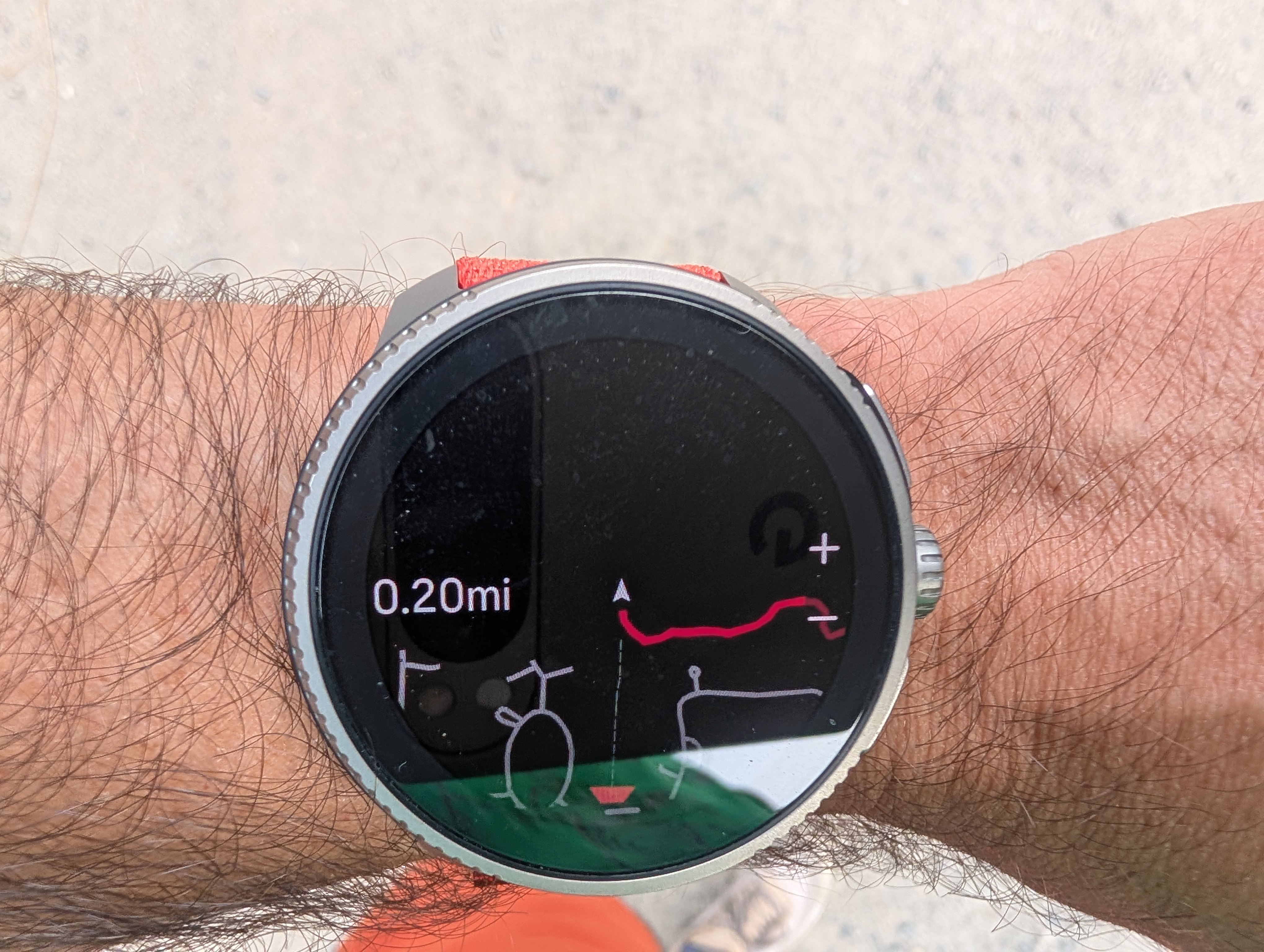
Are these trails shown on your watch as dashed lines with long dashes or short dashes that are closer in appearance to dotted lines? Long dashes are used for dirt roads and perhaps wide footpaths accessible by motor vehicles, and they stay visible on the map for one or two zoom levels longer. Short dashes that look more like dotted lines are used for all hiking trails. Here is I am standing at the entrance of a large nature park with a dense network of trails. There are trails going straight, left, and right from that location. What appears as a trail going down from the center is actually a wide gravel road. The zoom level is 0.2 miles which is just 320 meters:
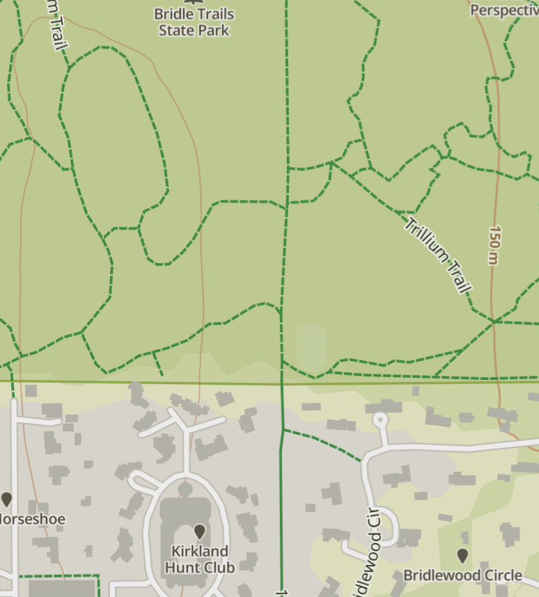
For comparison, here is the same place with roughly the same radius of visibility in the Suunto App:
-
@cheetah694 I only use Komoot for planning routes. I then assign them to the watch. That always works perfectly.
-
@sky-runner I’m not sure, as I had no navigation issues I just followed the track, but when I zoomed out a little I didn’t seem to loose any detail that was needed. Maybe if I was lost and trying to find a trail that would be different. I did have a map in my pack for an overview. I haven’t used the watch in mountains in the UK. Only low level walks or cycling on the road. Where the maps are excellent.
Funny really coming from a map and compass background, way before GPS was invented, I found and still find a paper map much more rewarding, it like reading a good book. Just following the watch/gps gets you there but you don’t understand the geography half as well


 ️
️Suunto Vertical
Suunto 9 BARO
Garmin Fenix 3, 5
Suunto Vector -
@Sportsfreund I’m also a Kamoot user. It works really well. Did just have a play with the Suunto planner. It looks interesting but lacks a lot of features you’d get with Kamoot.
-
@Audaxjoe Navigation and map should not be confused. These are two independent layers rendered one on top of another. Navigation can be used without a map as we have done for many years starting with Ambit series. Navigation track is rendered at any zoom level.
Similarly, map can be used with or without navigation. I often use just map for quick exploration of when I know the area in general but may not remember some specific details. For example, here is a fairly common for me case: I follow a trail and I remember that somewhere ahead there is a shortcut to another trail. I don’t have a preplanned navigation so I want to glance at the map from time to time to not miss that shortcut. The problem is that the radius of visibility is so short that I pretty much have to constantly look at the map to not miss that shortcut - I can’t see further than about 1 minute of running. So this kind of on the fly visual navigation is not really possible. Here is another example. Let’s say I do have a preplanned route, but for whatever reason I have to take a quick detour while having the original route in view and merge into the original route a bit further. Again, that is not possible because as soon as I zoom out just a little bit all the trails disappear from the map. So I can no longer use the watch map as a visual reference. This is more common than you might think because detours might be needed for a number of reasons - trail closure, decommissioned trails that I didn’t know about at the time of planning, a need to refill water, etc. To be honest, unless I have a preplanned navigation route and follow it exactly as planned without any deviation, using the map on my Suunto watch often frustrates me. I often have to stop and pull the phone and look at the map on the phone. I certainly almost never had to do that when I owned Garmin Fenix or even when I used Suunto Race prior to July 2025 update. This is the main reason I havn’t upgraded to Vertical 2 yet.
At this point, weighing all factors, Suunto still continues being the best watch for me, but just because it is the best choice from multiple not so good choices. But if Garmin addresses the map rendering and orientation fluidity, I’ll likely switch back to Garmin. Similarly, if Coros releases a watch with a large AMOLED display with the battery life similar to Race 2 or Vertical 2, I’ll switch to Coros because Coros maps are better.
-
@sky-runner
That’s interesting. I’ve just come back to Suunto from Coros and the maps are better than was available on my first series Apex Pro. I considered the new Apex 4 (which does have better mapping) but I wanted to try AMOLED for better visibility with older eyesight and mapping wasn’t my first priority.
Having said that I would value having more path detail on the wider zoom settings. I’m a fell runner - part of the game is traditional navigation with a map and compass and independent route choice between checkpoints. Use of a GPS device is against the rules except in an emergency.
But at other times, randomly exploring, especially in unfamiliar locations it would be nice to leave the map in the bag and be able to know there was a path on the opposite side of this ridgeline or that a track I’m following meets another a mile ahead. So Suunto yes please from me, I’d like the path detail on wider zoom settings too. -
@Dieter1960 I too have struggled with the same BT connectivity issues you re talking about. I have had zero issues with the H10 and The HRM Pro + when I leave both my iPhone and my Garmin at home. (Basically I have to run with only Suunto) If the HRM that is paired and being used for by the Vertical 2 is or has historically been used by any device (ie it recognizes the BT even though it is not paired) I will get intermittent signal. This has not always been the case and I am excited to see how the next firmware update fixes this issue. I have been super impressed with the OHR on the other hand, but I have not tried in in a VO2 max session or anything like that.
-
@Stavrogin The OHR on the Suunto V1 and V2 is really good. I’ve never had the problems that some people here are writing about.
-
@Sportsfreund I agree. I do have a larger wrist though and maybe that is what helps. Even though I have a large wrist the V2 is heavy and feels like it is moving during runs. Again maybe this is why some get less than ideal HR. I like a snug fit when running.
-
@Stavrogin I also have large wrists, but I don’t find the V2 heavy. It’s a shame that some users are having so many problems.
-
@Sportsfreund I agree with you on the so many people thing. TBH my battery life is not great. I am not getting 20 days with the V2, but the GPS battery life is great. I lose about 10% a day with a 1 hour GPS and no HR activity. If they doubled that I would say okay, but…
What wrist strap are you using with your V2? I don’t notice it unless I have my Apex 4 on. Also wrist matters. When it is on my left wrist it feels less “moving”. Having said that it hasn’t affected HR readings when I do use the OHR.
-
@Stavrogin i use the original white/blue one.
-
What is the Apex 4 belt?
-
@Sportsfreund Apex 4 is a Coros watch.
-
said in your honest thoughts:
Let’s say I do have a preplanned route, but for whatever reason I have to take a quick detour while having the original route in view and merge into the original route a bit further. Again, that is not possible because as soon as I zoom out just a little bit all the trails disappear from the map. So I can no longer use the watch map as a visual reference. This is more common than you might think because detours might be needed for a number of reasons - trail closure, decommissioned trails that I didn’t know about at the time of planning, a need to refill water, etc.
Just one day after my comment I’ve run into the exact case I described above. Today during my trail run I’ve run into a sign that told me that the trail ahead was closed and wasn’t passable and I now had to find a way around. This is how it looked on the watch while I was trying to connect a few alternative trails and still keep an eye on the original route. I am just 150 meters from the route and already I have no help from the watch to find the way around.
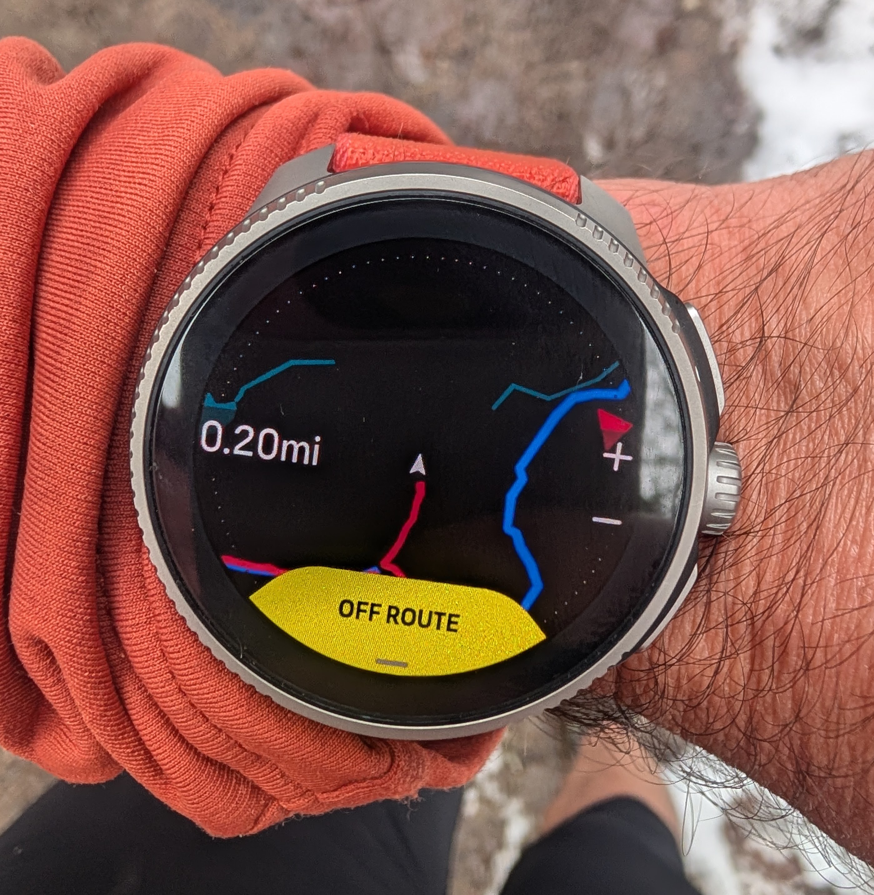
Also, adding salt to the injury, the crown stopped working (zooming the map) shortly after I took this picture and didn’t resume working until I had finished the run. Just perfect!