Suunto Routeplanner
-
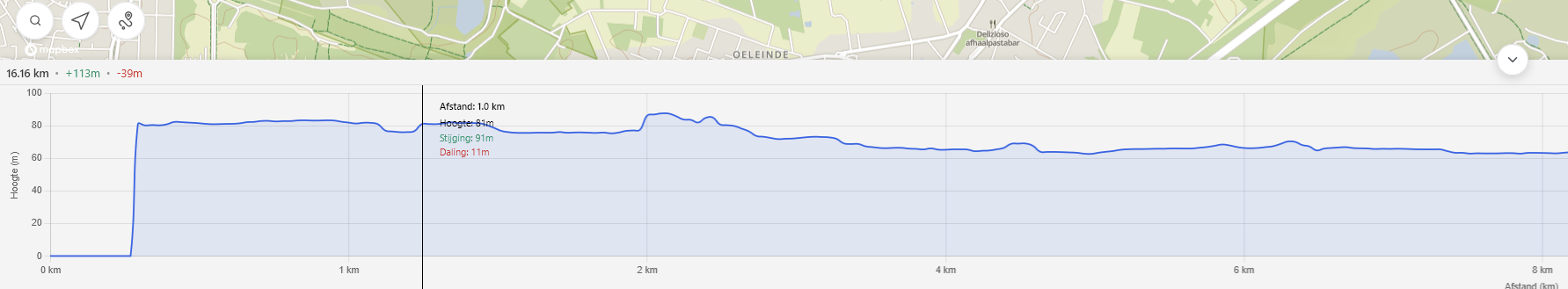
@kemetter There seems to be a bug in the distance scale along the x-axis when looking at the altitude profile.
Here is a long road run I’m planning. The jumps per grid line are erratic:
- 0 km
- 1 km (+1 km)
- 2 km (+1 km)
- 4 km (+2 km)
- 12 km (+8 km)
- 17 km (+5 km)
- 21 km (+4 km)
- 28 km (+7 km)
- 29 km (+1 km)
- 30 km (+1 km)
This is also consistent with a future planned mountain trail run also:
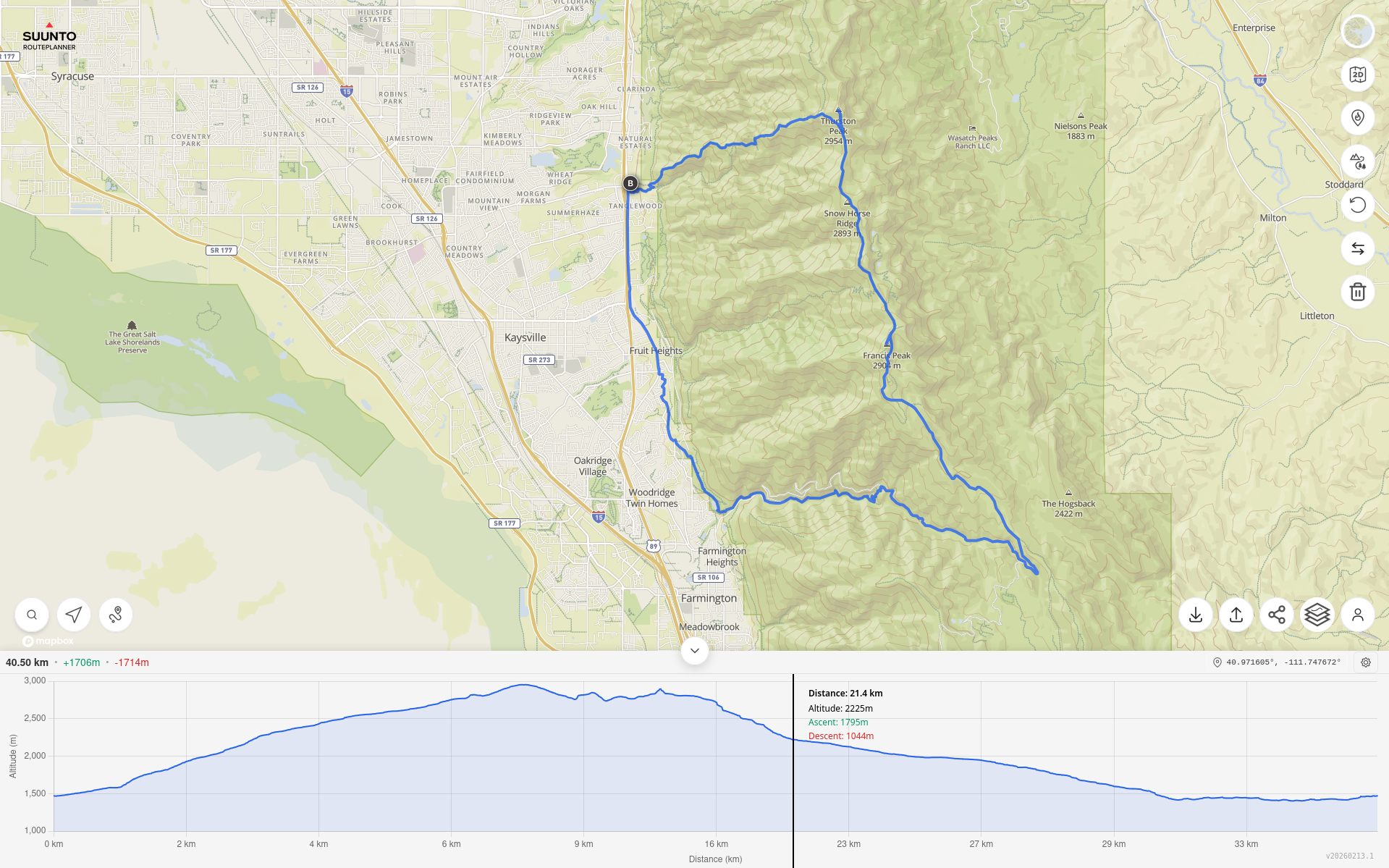
- 0 km
- 2 km (+2 km)
- 4 km (+2 km)
- 6 km (+2 km)
- 9 km (+3 km)
- 16 km (+7 km)
- 23 km (+7 km)
- 27 km (+4 km)
- 29 km (+2 km)
- 33 km (+4 km)
Has this bug been reported already? Or is there something to fix it?
Thanks.
Suunto Race S / 9 Baro / Ambit 3 Peak / Observer
Polar H10 / Verity Sense / OH1
Stryd Duo / Wind
r/suunto mod -
@sky-runner
First this.
I don’t use Strava, Suunto, Garmin, nor .fit files.
I’m just reading along and respond to the next comment:https://forum.suunto.com/post/185132
The GPX (trk) track mode with navigation wpt (waypoints) in Plotaroute is a Locus map track navigation method.
Unfortunately, Plotaroute does not offer the even simpler GPX (trk) track mode with navigation (trkpt) track points.The TBTs are supersimply discreetly placed in the (trkpt) sym element, yielding so excellent results.
Any route planner—Strava, Suunto, etc if desired can eventually apply this as well. (someday ?).In attachment: Issy Alps 50k_navtrk_12kmh.gpx
The demo GPX file is “discreetly” enriched with TBT trkpt’s , announced via trkpt’s inclusive the “separate” GPX wpt.
The via point info attached in the trkpt’s ensures their announcements is also automatically correctly timed.
The BRouter used for the demo file does not generate street names. The GPX format itself supports this as well if generated by the router engine of course.The Android Cruiser GPS app uses this simple GPX navtrk format. (Locus Map imports and navigates this gpx file as well)
The Cruiser navigation audio alerts, triggered xxx meters before the turns or via trackpoints distance is customizable.
The audio alerts are set as TTS or a (loud) tone indication. (Different for L/R/S)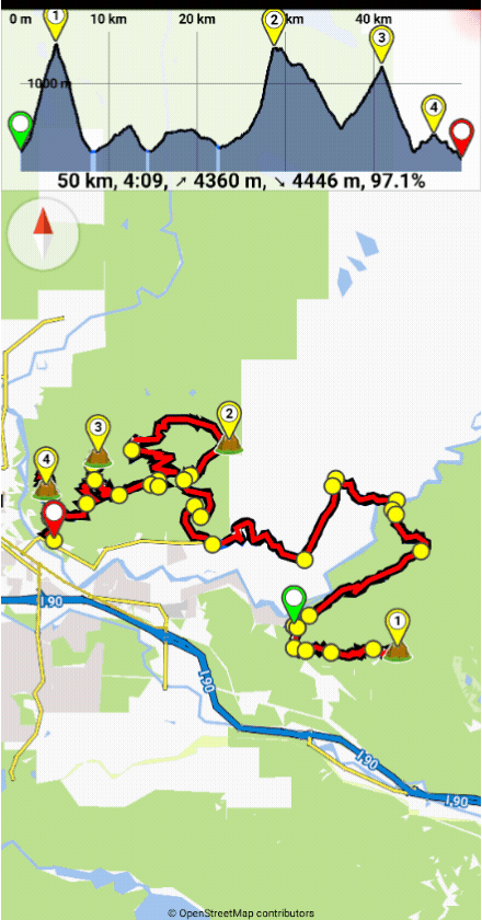
Translated with DeepL.com (free version)
-
Hey everyone!
After a lot of trial and error, I finally cracked a super simple way to turn any city walk into a personal audio-guided tour using just my Suunto watch + phone. No need for expensive apps or guided tours – works offline once set up, and it’s perfect for historic/architectural walks like in Oviedo, Spain.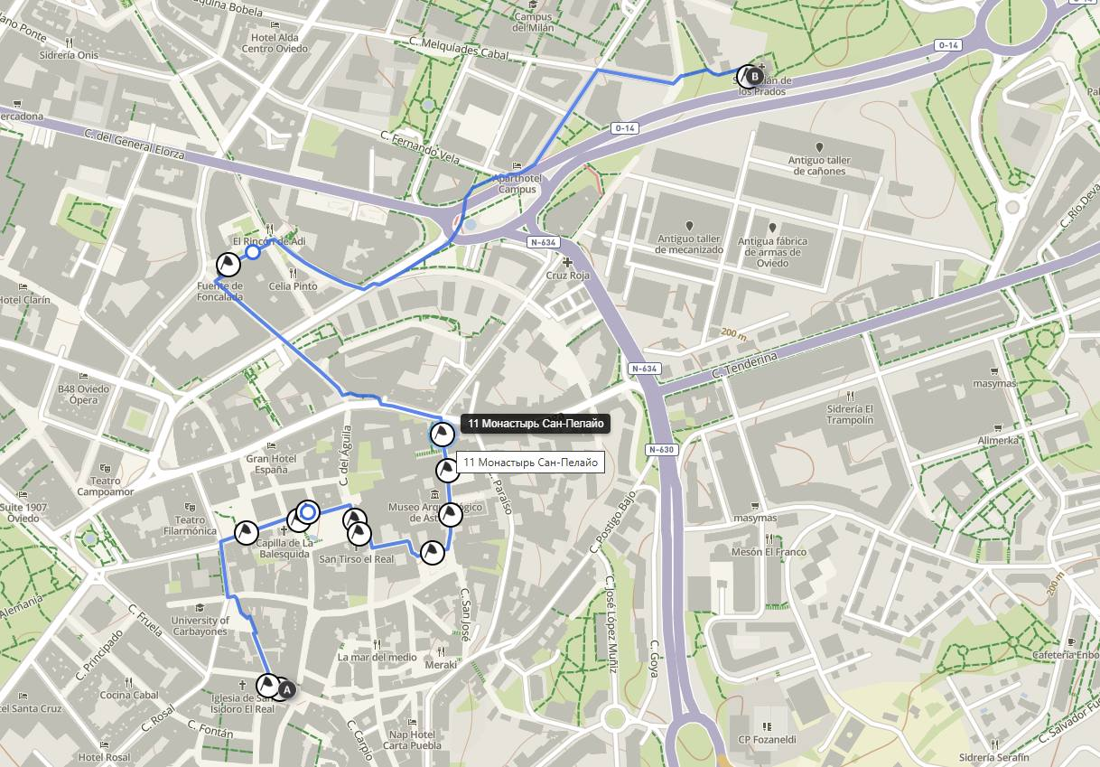
The key combo:-
Suunto Route Planner (web version: https://routeplanner.suunto.com/) for creating/planning the route and waypoints on a big screen.
-
list itemGPSmyCity tours (free self-guided walks with detailed descriptions): https://www.gpsmycity.com/tours/oviedo-historic-architecture-6280.html
-
list item@Voice Aloud Reader (Android TTS app) to read the tour descriptions aloud as you walk.
Step-by-step how I do it:
-
Pick a tour on GPSmyCity (e.g., “Oviedo Historic Architecture” – 2.7 km, ~2 hours, covers gems like Oviedo Town Hall, San Isidoro Church, Palace of the Counts of Toreno, Balesquida Chapel, Valdecarzana-Heredia Palace, and more – full list with descriptions on the page).
-
Open the page on your computer/phone → copy the full text (introduction + all stop descriptions). Paste into a note or Google Doc.
-
@Voice Aloud Reader:
- Import/share the text → it will read everything aloud (choose a nice voice, adjust speed).
- You can split into chapters by stop number for easy pause/resume, or just play sequentially.
- Bonus: offline TTS – download voice packs if needed.
- Create the route in Suunto Route Planner (browser):
- Go to https://routeplanner.suunto.com/
- Search for Oviedo → zoom in.
- Manually add points/waypoints by clicking on the map at each stop’s approximate location (use the tour descriptions for exact spots).
- Name each waypoint clearly (e.g., “1. Casa Consistorial de Oviedo (Town Hall)”, “2. Iglesia de San Isidoro”, etc.).
- The tool auto-connects with paths/roads – tweak as needed.
- Save the route → sync to your Suunto app → sync to watch (turn-by-turn navigation works great).
- Important tip about waypoints/GPX (learned the hard way!):
Waypoints added/edited in the Suunto app often don’t sync back to the web Route Planner properly (or get lost).
Always export the route as GPX from the web planner BEFORE syncing to watch (or right after creating). Keep a copy on your phone/computer.
If you need to edit later – import the GPX back into the planner (waypoints usually load if they were created there originally). Waypoints from watch → app → web don’t transfer reliably.
Result: On the walk, your watch guides you point-to-point (arrow + distance to next waypoint). At each stop – pause navigation if needed, tell @Voice to continue reading the description/history of that exact building/sculpture/site. Feels like a real audio guide!
This works for ANY city/place – just find a similar tour on GPSmyCity (tons of free ones), or even Wikipedia/Wikiloc/AllTrails descriptions. Super flexible for travel!
Has anyone else tried something similar? What TTS app do you use? Any tricks for better waypoint handling in Suunto?
Happy trails! ️
️

-
-
For testing, I attached my route.gpx file.
route.gpx
Even Better Prep: Virtual Tour with AI + Satellite Maps Before You Go!
Want to make your walk 10x more exciting and personalized? Do a virtual preview right from home!Open Google Maps / Google Earth (satellite view) or Apple Maps — zoom into your destination city (e.g., Oviedo historic center).
Switch to 3D/street view if available, or just satellite + street names.
Ask an AI (like Grok, ChatGPT, Claude, Gemini — any good one):
“Describe the top historic architecture highlights in Oviedo’s old town for someone who loves Pre-Romanesque and Baroque styles. Suggest a personalized walking order based on my interests: [your preferences, e.g., ancient fountains, cathedrals, hidden gems, avoid crowds]. Include why each spot is special and photo tips.”The AI will happily give you a tailored list with explanations — often better than generic guides! For example, it might prioritize La Foncalada (9th-century fountain), San Tirso Church (Pre-Romanesque), the Gothic Cathedral, Foncalada Fountain, San Julián de los Prados (UNESCO Pre-Romanesque with frescoes), etc., and suggest starting at the Town Hall for the best flow.
Then:Use the AI’s suggestions to fine-tune your waypoints in Suunto Route Planner (add custom notes like “Must-see: Victory Cross on Foncalada”).
Take screenshots of satellite views or AI descriptions — paste into your phone notes for offline reference.
Bonus: Ask AI for café recommendations at the end (e.g., “Best sidrería near Foncalada Fountain in Oviedo for a reward after the walk”).This way, you arrive already “knowing” the places, spot hidden details faster, and feel like a local explorer. Your walk becomes truly customized — no more surprises (only good ones)!
Anyone tried AI for pre-trip route personalization? Share your prompts or results! ️
️
-
Please consider the following purely for informational purposes.
As I was particularly curious about the Suunto web GPX export.
The web presentation is actually very well done.
The GPX export differs from what I expected")
See attachments:
Suunto_route.gpx
Suunto_navtrk.gpxThe Suunto GPX export and a comparable copy as a GPX navtrk file.
The original GPX file was manually edited for this purpose using Notepad++.
The GPX navrrk copy therefore so do not contain any trackpoint timestamps.
A few GPX WPTs have been added with a Garmin-compatible sym.
One of these GPX WPTs also contains an operational web link.
The GPX WPT list is not unnecessarily cluttered with turn instructions.
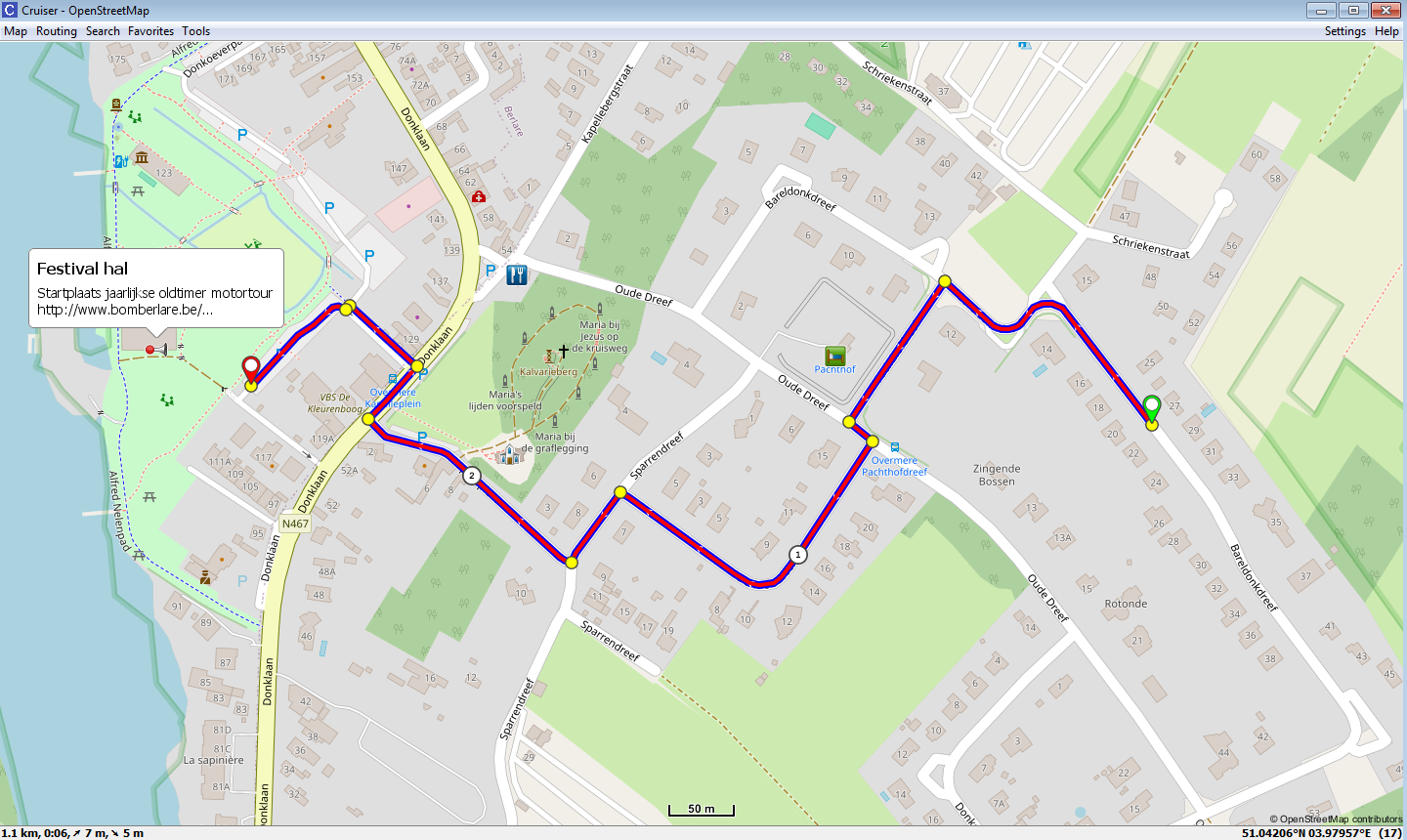
See also the presentation in the Cruiser desktop version.
Translated with DeepL.com (free version)
-
@Mff73 said in Suunto Routeplanner:
It is more how routes and Waypoints are handled in Suunto routing current mecanisms.
@ all
The Suunto Web Planner gpx export includes items 1 and 2.- A “direct” gpx (rte) route. (Rarely used)
Some apps treat such “direct” routes as tracks.
Other apps may refuse to import or even do crash. - Suunto gpx extension.
The gpx extension ensures the *association between gpx rtept and unique corresponding gpx wpt that contains the instructions.
Find some gpx variants. (Inclusive Suunto gpx extension).
Can a volunteer (watch owner) import, test and report pse ?A_Suunto_route.gpx (Original rte export)
B_Suunto_track.gpx (rte converted to trk)C_Suunto_route+wpt.gpx (A + extra wpt)
D_Suunto_track+wpt.gpx (B + extra wpt)E_Suunto_navtrk.gpx
F_Suunto_navtrk+wpt.gpxG_Basic_navtrk.gpx (Contains no gpx wpt nor gpx extensions)
- Association
The required strict association is handled differently in a Plotaroute (Locus) gpx export.
As this is applied in a very similar way as used in a Garmin tcx course_coursepoints file.
The Garmin tcx course with coursepoints file is the “forerunner” of true track tbt navigation.
- In a gpx tbt navigation track this “fragile” association complexity is unnecessary.
The instructions are directly attached in the relevant gpx (trkpt) trackpoints. (As well Cruiser and Locus map do navigate this file)
- A “direct” gpx (rte) route. (Rarely used)
-
@Willy
What do you want “us” to test?
Importability? Routability? Something else?
I read all your posts, all about gpx files, and still not sure to understand where you are trying to guide us.SSU (retired), SV1, SV2
Wife : S9PP
SA: Always the latest beta :)
Android + Galaxy S205G -
@Mff73
Importability.
The reference is the A (rte) file. (Original).
Do file B to G import as well ?
“I am most curious about the B (trk) result”- If succesfull than next
Routability.
Do files B to F show the TBT as well or not ?
If nok than test STOP and over and out
If ok than continue with a more complicated (multioverlap) track
- If succesfull than next
-
Hello @kemetter !
This is a great app for viewing and creating routes on a larger screen. Would it be possible to add a route generator that lets you enter parameters like “duration,” “distance,” and “elevation gain”? -
@Mff73
Import of gpx (trk)tracks in the Suunto Web Planner is positive.
Simple compare by “manually” adding the tbt data in trackpoints.
Manual edit prone to “typos.” In previous files one right should be left.
- Out-and-return overlap track test file series.
Observe compare and study, open in Notepad++
1A_Suunto out and return rte.gpx
1AA_Suunto out and return trk.gpx
1B_Suunto out and return navtrk.gpx
1C_Out and return navtrk.gpx
1D_ A small file sized compressed gpz version is possible
The upload of gpz or zip files is not possible in this forum
1E_Out_and_return_course.tcx
1F_Out_and_return_course.fit
The Suunto gpx extension only adds the via trackpoint bindings.
I seriously doubt this is sufficient for 100% TBT reliablility.
In the previous simple track the Suunto TBT generation is correct.
In the out-and-return track the Suunto TBT generation is incomplete.
Specifically 2 TBTs in the overlap return track section are missing.True Track TBT file modes.
https://github.com/osmandapp/OsmAnd/issues/14147#issuecomment-1114034225 - Out-and-return overlap track test file series.
-
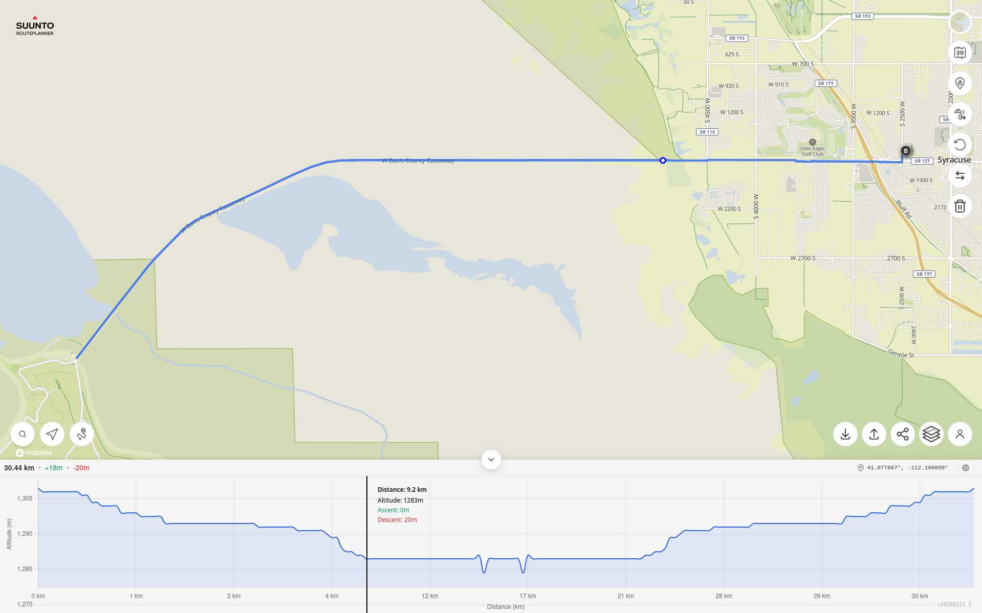
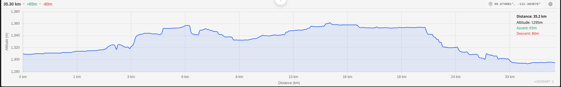
Planning another long run of ~35 km, give or take. As expected, the Suunto Route Planner has non-uniform spacing between distance ticks on the x-axis:
- 0 km
- 1 km (+1)
- 3 km (+2)
- 6 km (+3)
- 8 km (+2)
- 13 km (+5)
- 16 km (+3)
- 18 km (+2)
- 24 km (+6)
- 33 km (+9)
- 35 km (+2)
This gives a skewed view of the elevation profile:
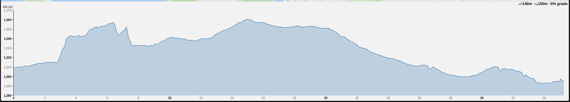
Compare to the uniform spacing using onthegomap.com:
Suunto Race S / 9 Baro / Ambit 3 Peak / Observer
Polar H10 / Verity Sense / OH1
Stryd Duo / Wind
r/suunto mod -
@atoponce Yes, I can confirm this strange behaviour.
-
@atoponce same here
-
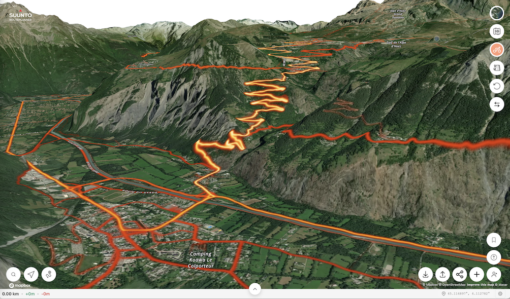
The problem with how trails and roads are displayed is simply disastrous - even in the route planner, compare the map at nearly the same scale and see how drastically it changes!
https://routeplanner.suunto.com/?lat=49.851338&lng=22.607213&zoom=13.1&style=outdoo
https://routeplanner.suunto.com/?lat=49.851338&lng=22.607213&zoom=12.95&style=outdoor
These aren’t watches, but maps on a computer - what’s the point of hiding so many roads?
Hello! It looks like you're interested in this conversation, but you don't have an account yet.
Getting fed up of having to scroll through the same posts each visit? When you register for an account, you'll always come back to exactly where you were before, and choose to be notified of new replies (either via email, or push notification). You'll also be able to save bookmarks and upvote posts to show your appreciation to other community members.
With your input, this post could be even better 💗
Register Login