Suunto app Forum Suunto Community Forum
    • Recent
    • Tags
    • Popular
    • Users
    • Groups
    • Register
    • Login

    Doubt about Suunto 9 Baro altimeter/barometer calibration

    Scheduled Pinned Locked Moved Suunto app - Questions & Feedback
    104 Posts 14 Posters 7.9k Views 17 Watching
    Loading More Posts
    • Oldest to Newest
    • Newest to Oldest
    • Most Votes
    Reply
    • Reply as topic
    Log in to reply
    This topic has been deleted. Only users with topic management privileges can see it.
    • Dimitrios KanellopoulosD Offline
      Dimitrios Kanellopoulos Community Manager @Mff73
      last edited by

      @Mff73 😮 that doesnt make so sense does it?

      Community Manager / Admin @Suunto
      Creator of Quantified-Self.io
      youtube.com/c/dimitrioskanellopoulos
      https://instagram.com/dimitrioskanellopoulos
      https://www.strava.com/athletes/7586105

      Mff73M 1 Reply Last reply Reply Quote 0
      • Mff73M Online
        Mff73 @Dimitrios Kanellopoulos
        last edited by

        @Dimitrios-Kanellopoulos
        Strange indeed.
        My remark is more oriented on the fact that I read many posts here and in other forums, where people ā€œcomplainā€ about this ā€œaltitudeā€.
        Something behind or just more people doing ascent during summer šŸ¤”.

        Suunto Spartan Ultra (since 2016) FW: 2.8.24 (retired)
        Suunto Vertical all black
        Wife : S9PP
        SA: Always the latest beta :)
        Android 13, Galaxy S205G

        1 Reply Last reply Reply Quote 1
        • J Offline
          johann.fuehrer Bronze Member @Mff73
          last edited by johann.fuehrer

          @Mff73 May I ask how you did drive? Bike, Train, Car? My assumption is, that when you go ie. by car, it is not recognized as movement and therefore the altimeter stays on the ā€œhomeā€ level. I think this is how fused alti works. Could it be that there are really 100m altitude difference between ā€œhomeā€ and end of drive and vice versa?

          Mff73M 1 Reply Last reply Reply Quote 0
          • Mff73M Online
            Mff73 @johann.fuehrer
            last edited by

            @johann-fuehrer
            Thanks for answering.
            I made a mistake šŸ˜ž
            Altitude ok at home before and after activity in watch mode.
            Ride by car from 550m to 1610m (real) without recording, so watch in ā€œautoā€ mode . Not checked the altitude at start
            Then hike from 1610 to 2110 real (summit) and here is Altitude vs GPS altitude.
            Conclusion : no fusedalti in my hiking activity.
            Btw, alti at home is OK before and after.

            024dbfa2-7da7-49b5-9a67-a45c3209342d-image.png

            Suunto Spartan Ultra (since 2016) FW: 2.8.24 (retired)
            Suunto Vertical all black
            Wife : S9PP
            SA: Always the latest beta :)
            Android 13, Galaxy S205G

            J 1 Reply Last reply Reply Quote 1
            • J Offline
              johann.fuehrer Bronze Member @Mff73
              last edited by

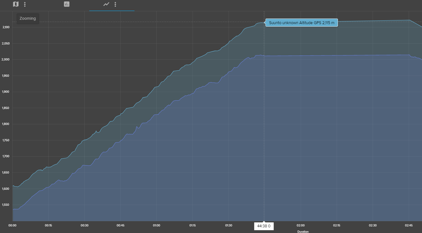
              @Mff73 I think to solve this we would need to know the trigger for an altitude change when in watch mode - so when the watch assumes you are moving or static. Maybe some wrist movements triggers this from time to time. That would explain, why the difference is ā€œonlyā€ 100m and not the full 1000m difference from ā€œhomeā€ to hiking start point.

              freeheelerF 1 Reply Last reply Reply Quote 0
              • freeheelerF Offline
                freeheeler @johann.fuehrer
                last edited by freeheeler

                @johann-fuehrer
                I know I’m a bit offtopic since I am an old fashioned Ambit guy, but it seems to be a topic about fused alti, too?!

                On Friday I went on a biketour (the one that we had to dig out our phones and maps for since we could not create a new route in MC and could not sync SA to Ambit…) and while we were in the gondola to get to the start of our tour (yes, sometimes I skip the pedalling part šŸ˜‰ ) I did the calibration manually as automatic calibration with fused alti always takes ages…
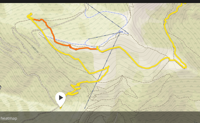
                In SA, I noticed later that the total ascent and the maximum altitude must be wrong. Also the altitude profile is not really what it looks like on the map…
                The orange dot was at the actual highest point which is on the map at about 1’600m.

                Screenshot_20190819-135202.png

                living sideways

                J 2 Replies Last reply Reply Quote 0
                • J Offline
                  johann.fuehrer Bronze Member @freeheeler
                  last edited by johann.fuehrer

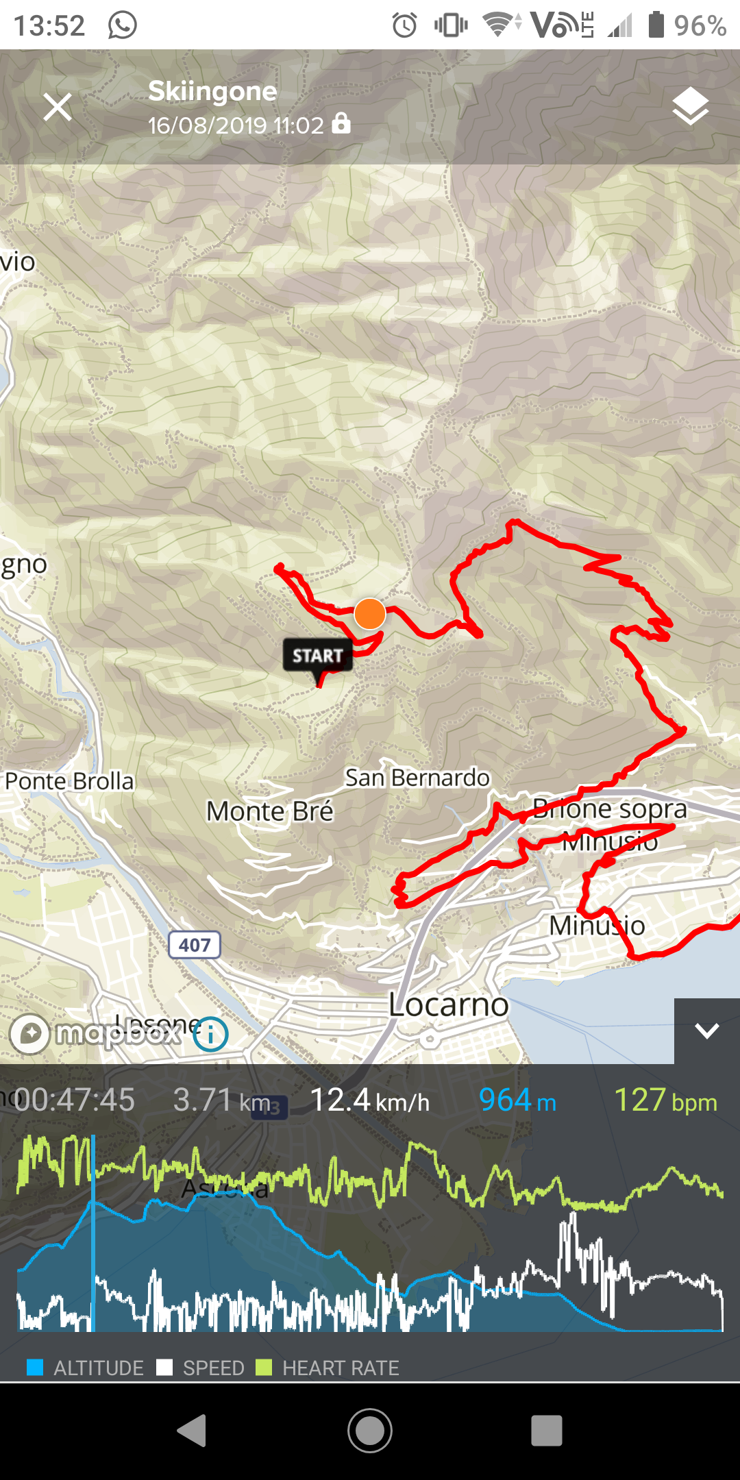
                  @TELE-HO You are sure your baro is ok? It looks like it could not keep up with a ā€œquickā€ altitude change when going up (and also when going down). If your baro holes are blocked (partially) it might be that the higher pressure from the base that you had in your watch, could not get out through this holes quick enough and therefore showing a wrong altitude (too low). But it seems that later this gets better. But strange in any way…

                  freeheelerF 1 Reply Last reply Reply Quote 0
                  • J Offline
                    johann.fuehrer Bronze Member @freeheeler
                    last edited by

                    @TELE-HO would be interesting to see the change compared to a real altitude graph…

                    1 Reply Last reply Reply Quote 0
                    • freeheelerF Offline
                      freeheeler @johann.fuehrer
                      last edited by

                      @johann-fuehrer
                      yes, almost new watch and I am aware of the baro holes issue from my earlier Suunto Core…
                      The activities before and after were recorded without any issue, like I am used to.
                      I am pretty sure I confused fused alti with manual setting while ā€œclimbingā€ in the gondola and then immediately starting the activity.

                      living sideways

                      freeheelerF 1 Reply Last reply Reply Quote 0
                      • freeheelerF Offline
                        freeheeler @freeheeler
                        last edited by

                        @TELE-HO
                        this is roughly the graph of the route when I draw it in MC map.
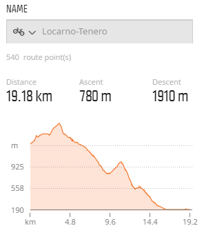
                        3d257358-7ea5-496c-b5e2-805b5a39a45b-image.png

                        living sideways

                        mario_bM J 2 Replies Last reply Reply Quote 0
                        • mario_bM Offline
                          mario_b @freeheeler
                          last edited by

                          @TELE-HO AFAIK if you manually calibrate the altitude while recording an activity, fused-alti will be disabled. not if you calibrate it before an activity. would be nice to see this activity in MC šŸ™‚ because allways when fused-alti calibrates the altitude for more then around 8 meters, you see the pressure change in the baro diagram.

                          freeheelerF 1 Reply Last reply Reply Quote 0
                          • J Offline
                            johann.fuehrer Bronze Member @freeheeler
                            last edited by johann.fuehrer

                            @TELE-HO Is it possible for you to merge this one and the recorded one in to one graph? Maybe quantified.io is helpful? I did nor use it yet, but have seen a lot of such stuff is done in there by others…

                            Dimitrios KanellopoulosD 1 Reply Last reply Reply Quote 0
                            • Dimitrios KanellopoulosD Offline
                              Dimitrios Kanellopoulos Community Manager @johann.fuehrer
                              last edited by

                              @johann-fuehrer Jup that is possible

                              Community Manager / Admin @Suunto
                              Creator of Quantified-Self.io
                              youtube.com/c/dimitrioskanellopoulos
                              https://instagram.com/dimitrioskanellopoulos
                              https://www.strava.com/athletes/7586105

                              1 Reply Last reply Reply Quote 0
                              • freeheelerF Offline
                                freeheeler @mario_b
                                last edited by

                                @mario_b
                                yes I am aware that you switch off fused alti when manual calibrating during an activity recording.
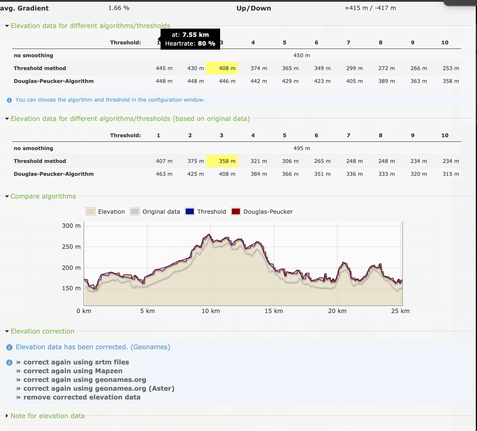
                                Here’s the sea level pressure with the altitude profile.

                                @Dimitrios-Kanellopoulos
                                I don’t know who to do an overlay… but if I do an overlay, it would be necessary to have it almost idential from the drawn to the recorded track to have the best comparison, right?
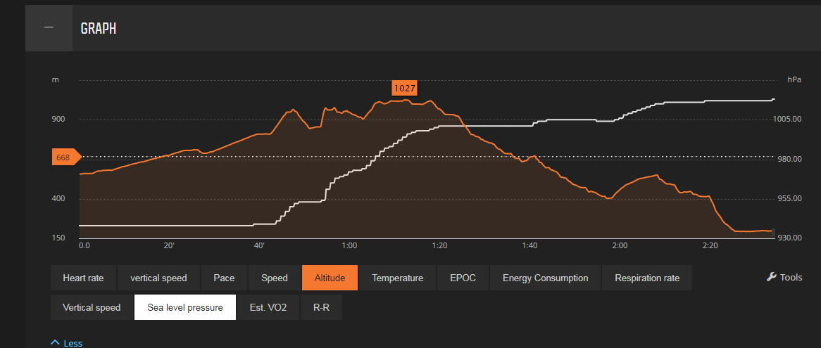
                                6414a92e-187c-478b-9d3c-00e2324642f5-image.png

                                living sideways

                                Dimitrios KanellopoulosD J mario_bM 3 Replies Last reply Reply Quote 0
                                • Dimitrios KanellopoulosD Offline
                                  Dimitrios Kanellopoulos Community Manager @freeheeler
                                  last edited by

                                  @TELE-HO update 2 activiteis / routes to QS.
                                  Select them on the table
                                  Press merge
                                  Use the distance axis when viewing

                                  Community Manager / Admin @Suunto
                                  Creator of Quantified-Self.io
                                  youtube.com/c/dimitrioskanellopoulos
                                  https://instagram.com/dimitrioskanellopoulos
                                  https://www.strava.com/athletes/7586105

                                  1 Reply Last reply Reply Quote 0
                                  • J Offline
                                    johann.fuehrer Bronze Member @freeheeler
                                    last edited by

                                    @TELE-HO for a GPX track you can get ā€œrealā€ altitude information here i.e. https://www.gpsvisualizer.com/elevation but I do not know how exact that is…

                                    J 1 Reply Last reply Reply Quote 0
                                    • J Offline
                                      johann.fuehrer Bronze Member @johann.fuehrer
                                      last edited by

                                      @johann-fuehrer … it’s a 30m x 30m grid SRTM1

                                      1 Reply Last reply Reply Quote 0
                                      • Dimitrios KanellopoulosD Offline
                                        Dimitrios Kanellopoulos Community Manager
                                        last edited by

                                        Runanalyze!

                                        Screenshot 2019-08-19 at 15.13.47.png

                                        Community Manager / Admin @Suunto
                                        Creator of Quantified-Self.io
                                        youtube.com/c/dimitrioskanellopoulos
                                        https://instagram.com/dimitrioskanellopoulos
                                        https://www.strava.com/athletes/7586105

                                        1 Reply Last reply Reply Quote 1
                                        • mario_bM Offline
                                          mario_b @freeheeler
                                          last edited by

                                          @TELE-HO perfect. i think you’ve being right, as you said, that i could be, because you calibrated it on the gondola.
                                          as you can see, fused-alti is correcting the altitude all the time on the activity to a higher altitude. is the altitude value on the end of the activity nearly correct?

                                          freeheelerF 1 Reply Last reply Reply Quote 0
                                          • freeheelerF Offline
                                            freeheeler @mario_b
                                            last edited by

                                            @mario_b
                                            yes, it is absolutely correct at the end.

                                            I just noticed that I’ve had a GPS precision issue for the first 35minutes of this activity anyway. I wanted to redraw the exact route but saw that the signal was off track at the beginning… it does not make sense to overlay my recorded move with a drawn route I think.

                                            c02a811e-6f7e-4a16-9ca7-9966aefad5ea-image.png

                                            living sideways

                                            mario_bM 1 Reply Last reply Reply Quote 0
                                            • First post
                                              Last post

                                            Suunto Terms | Privacy Policy