Suunto 7 Altitude Issues
-
@brad_olwin I have friends with this issue with the s7. Until may I can’t test it, but I want to make some test between handlebar, wrist, s9 and s7.
For me the s7 in the bike in the handlebar is not a good choice because you won’t have HR.
-
Better and better with my S7 today trail running

- real ascent = 1000m (calculate with map)
- watch ascent = 1890m
- application ascent = 0m
https://www.suunto.com/move/cedric13/6037a8dad62ee20f98d61f32
And for the joke the gps recording stop alone before the end

So, my last chance is calling the support, this watch is only 2 months old… my Ambit 3 after 4 years still working very well.

I bought new watch only because Suunto stopped Movescount support , but why ??? You’re crazy to kill yourself 🤨 -
@cedric13 I would contact support if I was you.
-
@cedric13
don’t give up. My wife had a faulty A3R and it was exchanged without the slightest discussion. Sometimes failures sneak into products, but Suunto service is what many many other companies should take as benchmark
-
@cedric13 We cannot see much from the link. Do you use Quantified Self? Import your file there and give use the link, we can then look at the altitude data much better.
-
@cedric13 There seems to be S7 quality assurance issues but maybe that’s bias because there is small sample size from amount sold. I wonder how many are out there with insanely bad altitude issues. Mine was doubling altitude out of the box and reset did nothing. If it wasn’t for the GPX files that I preloaded, knowing the elevation, I would have no idea mine was faulty. I think there should a survey going out and a recall in order.
It’s a great design that’s almost impossible to cover the baro hole so that’s not the issue.I tried sideloading a alti/baro calibrator app from XDA and I can post the link if you are interested. It didn’t help my situation at all though. The app detects when there is unusual pressure on your baro which is cool.
A good way to troubleshoot it would be to do a peak hike (only up and down) then analyze it in Quantified Self. My specific problem was very wavy stats. So if i was walking up a hill every 2meter (for example) vertical I walked, it would go down 2m then go back up to 4m leaving me with 4m up (ascent) and 2m (descent) down while it was just 2m up in real life. It was accurate on my altitude points like (min, mid, max), I know this because i was at a ski resort and it had signs telling me what altitude i was at and it says it on the gpx file as well.
I just sent mine in a couple days ago. It was a very easy and smooth process which is free. It took 2 days to get to finland from a small town in france.
I’ll comment back on here what the solution is and when I get mine back. But this is the solution you should do. It’s a 400euro watch you should just get it looked at. But make sure to give them an insane amount of data (crossing my fingers that i explained it to them thoroughly enough) -
@brad_olwin please to find below the export FIT from Suunto App, if you can find some ideas about the issue, thanks !
-
@cedric13 I tried importing your file in Runalyze and play with elevation correction. Get between 800 and 1000 meters of elevation gain depending on the altitude provider I use.
So anywhere between 800 to 600 meters less than you measured.
The profile though is not too bad. I’ll see how it looks in QS. -
@cedric13
@isazi
I have no S7, and these issues make me wonder one thing : S7 is syncing with SuuntoApp right ?
Is there any raw data files in Android app folders, like we have for Spartans (at least) ?For sure, we have not so many tools to fully help for all these kinds of issues

Fit file is nice, but it is Suuntocloud generated, and in this one, no ascent as well, despite the fact there is some ascent meters

-
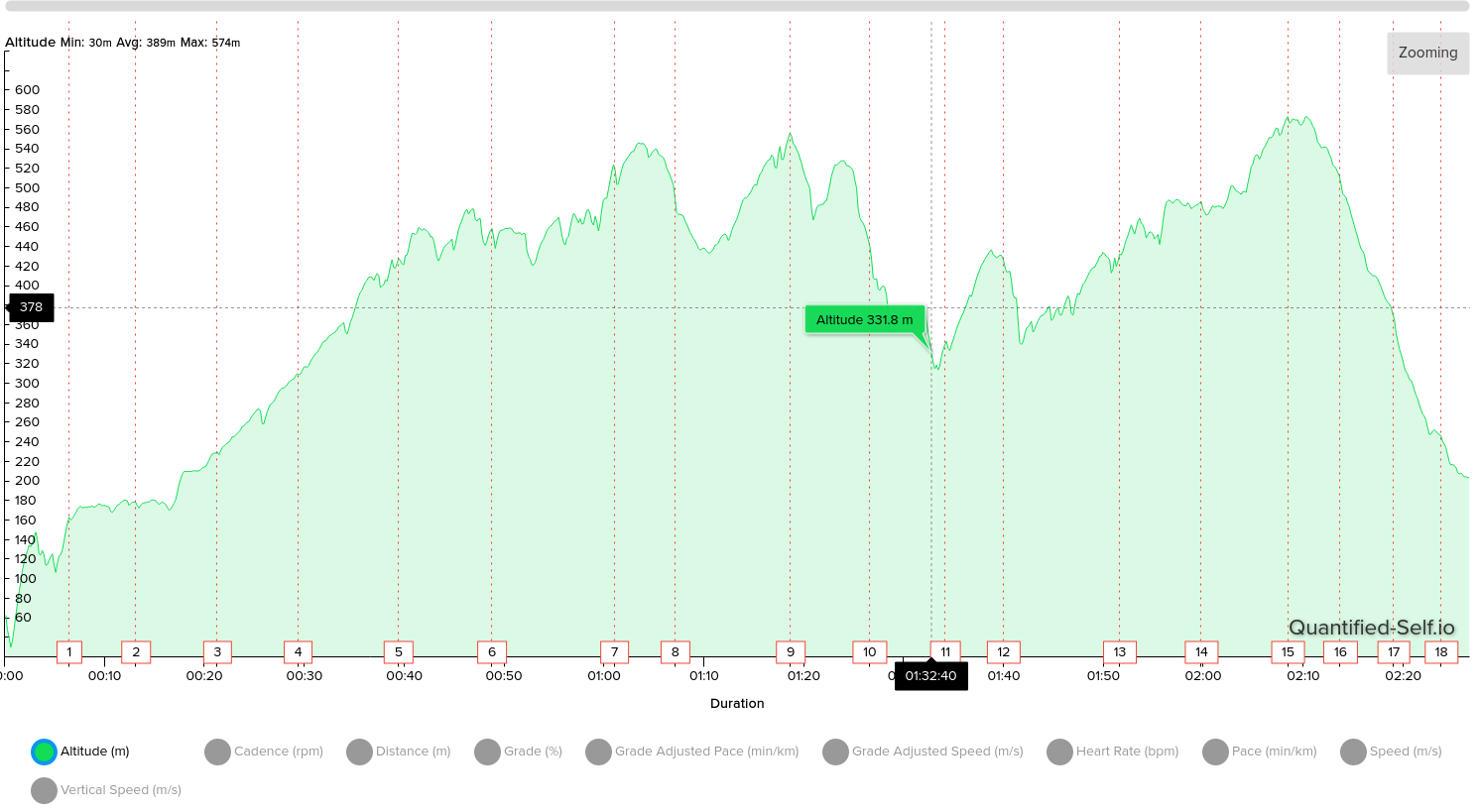
@cedric13 this is the altitude profile in QS.

-
@isazi maybe that climb at the beginning is the error?
-
@eurohiker - pointless looking at anyting within the 3m range - if I remember correctly discounts anything less than 3m. So yes you can get those weird things where you take a slightly different route and end up with 9m up and 6m down, but at same start point, as a descent wasn’t registered as the variance at the descent points was too small to measure.
I tend to find that this can occur for me, as a lot of the routes I use are reasonably flat with small short gradients, and if I do use slightly different or cirucular routes, rather than and a there and back route, yes I will get different ascent and descent values - due to what is ignored.
Saying that on the couple of higher hikes where altitude has changed by a couple of hundred meters, it has always seemed to pretty much tie in, and match back to contour lines (of course as the contour lines where 20m intervals - as long as I was within that range I am OK.
-
@jamie-bg the 2m was just a small scale example.
Every single activity I did doubled in altitude at the end of the hike. Even though it was stating i was at the correct altitude while at base, peak and when ever else i checked it with the contour lines.
I know it was at the correct altitude because I looked at fatmap, alltrails, gaia gps and read the altitude sign at the peaks.I’m just stating what my “wavy” data looked like that’s all. It wasn’t my real data.
-
@isazi thank you for your analyse.
The climb at the beginning is real, it’s very steep in my area
Maybe a smartwatch is meanly dedicated for townsman geek and not trail runner ?
For my experience S7 is more a nice gadget than a real serious sport watch. I will ask support if I can change for a S9 by example… -
@cedric13
it is for sure not the successor of mountain men’s A3PS, but I consider it the best split between a smart and sportwatch.
My wife has one and she does happily with it marathon training, swimming, MTB and ski touring. -
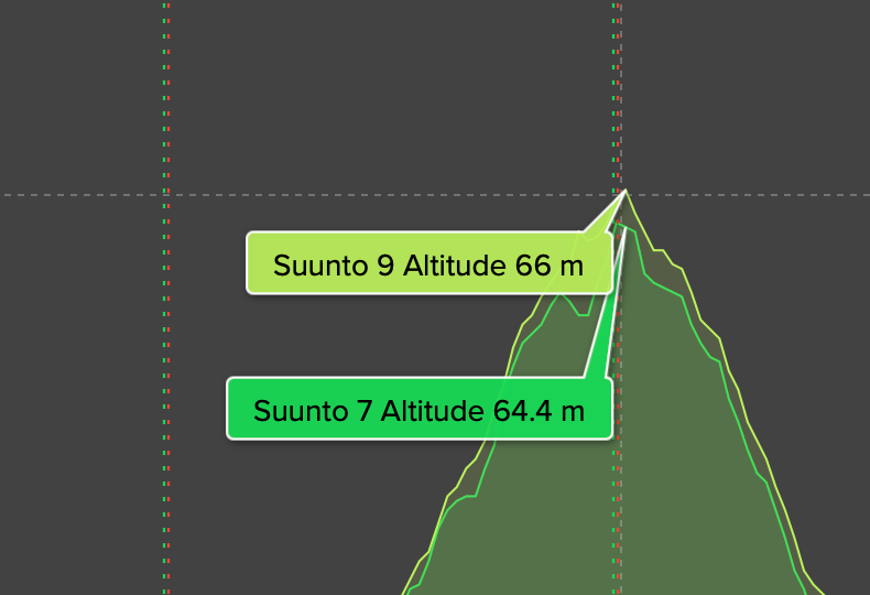
Today s7 and s9b:

-
@bulkan said in Suunto 7 Altitude Issues:
s7 and s9b
Do you have a comparison of the absolute altitude between the two watches?
-
@pilleus yes,
66 vs 64,4
-
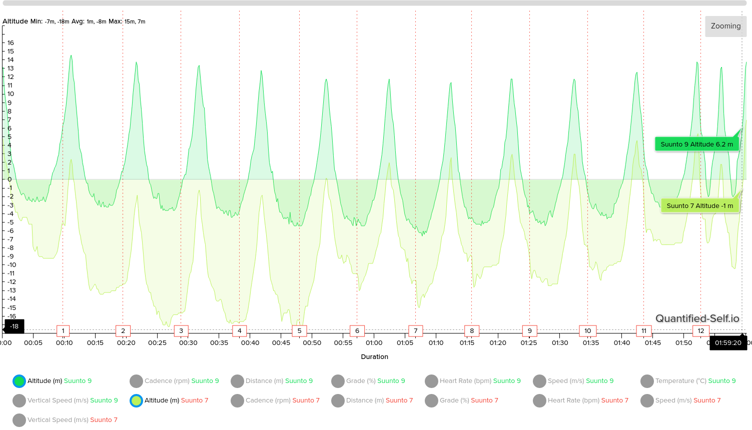
Today I did some walking hill repeats with both S9 and S7. Here the results of my comparison:
Ascent and average altitude:

Descent:

Starting altitude:

And then end altitude:

The graph:

S9 was on right wrist, S7 on left.
-
