• Recent
  • Tags
  • Popular
  • Users
  • Groups
  • Register
  • Login
Suunto app Forum Suunto Community Forum
  • Recent
  • Tags
  • Popular
  • Users
  • Groups
  • Register
  • Login

Issues altitude diagram

Scheduled Pinned Locked Moved Spartan
54 Posts 10 Posters 3.3k Views 10 Watching
Loading More Posts
  • Oldest to Newest
  • Newest to Oldest
  • Most Votes
Reply
  • Reply as topic
Log in to reply
This topic has been deleted. Only users with topic management privileges can see it.
  • S Offline
    Stefan Kersting @Dimitrios Kanellopoulos
    last edited by 14 Sept 2020, 19:05

    @Dimitrios-Kanellopoulos ok then I have to wait more than 2-3 minutes…

    Instagram: https://www.instagram.com/helgelandsbukken/
    https://www.instagram.com/suunto_adventures/
    IG: Helgelandsbukken, suunto_adventures
    Vimeo: vimeo.com/helgelandsbukken
    Blogg: https://turblogg.midnattsola.com

    1 Reply Last reply Reply Quote 0
    • S Offline
      Stefan Kersting @Brad_Olwin
      last edited by 14 Sept 2020, 19:12

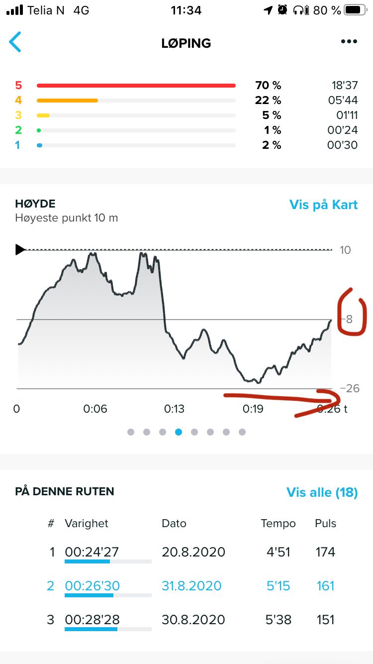
      @Brad_Olwin now I did a hike and not a run in order to have enough time to follow the altitude on the watch. The interesting thing was that I started at an altitude of 5 masl and with a fast ascent to 30 masl and after a short time the altitude was at 13masl which was realistic. So that must be an issue with the satellite fix at the start. BUT I have never seen a negative altitude on the watch and when downloaded I see that the lowest point was registered with -15 below sea level. So now I don’t understand anything. The watch displays another altitude than SA…
      E22434CC-2900-4F9D-B311-F9E538EC4368.jpeg

      Instagram: https://www.instagram.com/helgelandsbukken/
      https://www.instagram.com/suunto_adventures/
      IG: Helgelandsbukken, suunto_adventures
      Vimeo: vimeo.com/helgelandsbukken
      Blogg: https://turblogg.midnattsola.com

      1 Reply Last reply Reply Quote 0
      • J Offline
        johann.fuehrer Bronze Member
        last edited by johann.fuehrer 14 Sept 2020, 19:22

        Hello, I’m surprised that this “my altitude does not match with my map reading” topic is coming up ever and ever again. I have written about this somewhere in the past, so here some information from guys who know what it is about: https://www.usgs.gov/faqs/why-dont-elevations-your-maps-agree-those-provided-my-gps-system-which-ones-are-correct?qt-news_science_products=0#qt-news_science_products

        This is one of the reasons, Garmin brought in DEM data to Fenix models (I think mesh points in 30m grid)…

        That is why I suggested a local offset which CAN be set manually and would shift the GPS altitude calculated by this offset for EVREY altitude value - right ones and wrong ones (bad GPS, abro i.e.). So also fused alti would work. It would not touch the GPS altitude reading and calculation directly, but after getting GPS altitude + fused alti calculations, it would add/sub the local offset of the GPS_geoid_to_real_map_alti difference which has been set manually. my5c

        (which would mean: exact the same altitude profile but shiftet to real altitude due to offset…)

        F D 2 Replies Last reply 14 Sept 2020, 19:28 Reply Quote 0
        • F Offline
          Fenr1r @johann.fuehrer
          last edited by Fenr1r 14 Sept 2020, 19:28

          @johann-fuehrer said in Issues altitude diagram:

          TruFusedAlti. Do we know if Suunto uses the datum elevation or that from satellite triangulation? Or one and then the other?

          my5c

          Inflation?

          J 1 Reply Last reply 14 Sept 2020, 19:44 Reply Quote 0
          • D Offline
            Dimitrios Kanellopoulos Community Manager @johann.fuehrer
            last edited by 14 Sept 2020, 19:42

            @johann-fuehrer afaik Suunto uses mean sea level. What am I missing ?

            Community Manager / Admin @Suunto
            Creator of Quantified-Self.io
            youtube.com/c/dimitrioskanellopoulos
            https://instagram.com/dimitrioskanellopoulos
            https://www.strava.com/athletes/7586105

            J 1 Reply Last reply 14 Sept 2020, 20:03 Reply Quote 0
            • J Offline
              johann.fuehrer Bronze Member @Fenr1r
              last edited by 14 Sept 2020, 19:44

              @Fenr1r said in Issues altitude diagram:

              @johann-fuehrer said in Issues altitude diagram:

              TruFusedAlti. Do we know if Suunto uses the datum elevation or that from satellite triangulation? Or one and then the other?

              Dont know. BTW: This was the thread & post I referred to, needed some time to find it again 😉 … https://forum.suunto.com/post/36919

              F 1 Reply Last reply 14 Sept 2020, 19:52 Reply Quote 0
              • F Offline
                Fenr1r @johann.fuehrer
                last edited by 14 Sept 2020, 19:52

                @johann-fuehrer Thank you. Very interesting and now my head hurts.

                J 1 Reply Last reply 14 Sept 2020, 20:05 Reply Quote 0
                • J Offline
                  johann.fuehrer Bronze Member @Dimitrios Kanellopoulos
                  last edited by 14 Sept 2020, 20:03

                  @Dimitrios-Kanellopoulos said in Issues altitude diagram:

                  @johann-fuehrer afaik Suunto uses mean sea level. What am I missing ?

                  The physical model of Earth and the mathematical model of GPS geoid do not match. Not in altitude (and also not in horizontal offsets, but let’s forget this by now). Maps are not based on the GPS geoid but of some agreed MSL - but not to the same over the whole world (https://en.wikipedia.org/wiki/Vertical_datum)
                  There is lot of stuff about this on the internet, and to what funny results this led like tunnes planned by two different countries which did not met, bridges and other stuff. But the main conclusion is: GPS watches calculate the altitude based on a “ideal” world shape, which does not 100% match. For some parts of the world the altitude calculated match perfect, on others it’s way off (there is some map about the offset here: https://www.esri.com/news/arcuser/0703/geoid1of3.html) . DEM models have correction information based on the location for the GPS calculated values.

                  So for places on earth where the GPS and map data have a “natual” offset, you need an additional correction, if you want to be precise - or live with the altitude profile being OK but have a small or bigger offset.

                  D 1 Reply Last reply 14 Sept 2020, 20:08 Reply Quote 1
                  • J Offline
                    johann.fuehrer Bronze Member @Fenr1r
                    last edited by 14 Sept 2020, 20:05

                    @Fenr1r said in Issues altitude diagram:

                    @johann-fuehrer Thank you. Very interesting and now my head hurts.

                    I’m sorry for your headaches…

                    D F 2 Replies Last reply 14 Sept 2020, 20:06 Reply Quote 0
                    • D Offline
                      Dimitrios Kanellopoulos Community Manager @johann.fuehrer
                      last edited by 14 Sept 2020, 20:06

                      @johann-fuehrer I have a headache as well 🙂

                      Community Manager / Admin @Suunto
                      Creator of Quantified-Self.io
                      youtube.com/c/dimitrioskanellopoulos
                      https://instagram.com/dimitrioskanellopoulos
                      https://www.strava.com/athletes/7586105

                      J 1 Reply Last reply 14 Sept 2020, 20:09 Reply Quote 0
                      • D Offline
                        Dimitrios Kanellopoulos Community Manager @johann.fuehrer
                        last edited by 14 Sept 2020, 20:08

                        @johann-fuehrer at the same time I hear / read in other groups of garmin that the DEM is not ok. Am I wrong 😞 ? I am asking not to downplay Garmin, I love DEM, but I want to know in practice. At least if it solves issues like @johann-fuehrer has or even @Stefan-Kersting

                        Community Manager / Admin @Suunto
                        Creator of Quantified-Self.io
                        youtube.com/c/dimitrioskanellopoulos
                        https://instagram.com/dimitrioskanellopoulos
                        https://www.strava.com/athletes/7586105

                        J 1 Reply Last reply 14 Sept 2020, 20:19 Reply Quote 0
                        • J Offline
                          johann.fuehrer Bronze Member @Dimitrios Kanellopoulos
                          last edited by 14 Sept 2020, 20:09

                          @Dimitrios-Kanellopoulos said in Issues altitude diagram:

                          @johann-fuehrer I have a headache as well 🙂

                          @Fenr1r @Dimitrios-Kanellopoulos

                          c395cb23-8f9e-4158-9257-f7c199b23706-image.png
                          https://imgs.xkcd.com/comics/headache.png

                          1 Reply Last reply Reply Quote 2
                          • F Offline
                            Fenr1r @johann.fuehrer
                            last edited by Fenr1r 14 Sept 2020, 20:12

                            @johann-fuehrer @Dimitrios-Kanellopoulos

                            You see, the problem is with the inexact spheroidal shape of our heads vis à vis mean sea level, air pressure and Mondays. Also noses.

                            @Dimitrios-Kanellopoulos as for @Stefan-Kersting: so Suunto doesn’t use it? Seems like a good case to look at, I agree.

                            1 Reply Last reply Reply Quote 1
                            • S Offline
                              Stefan Kersting
                              last edited by 14 Sept 2020, 20:15

                              One of my thoughts was that the problem is that I live 67 degrees north and the gps satellite coverage is not as good as in lower latitudes. The satellites are not as high above the horizon as eg in Central Europe. So the constellation results on lower precision. But the case I described in my last post can’t connect to that issue i think. There must be a missing link between the altitude displayed on the watch and displayed/recalculated in SA

                              Instagram: https://www.instagram.com/helgelandsbukken/
                              https://www.instagram.com/suunto_adventures/
                              IG: Helgelandsbukken, suunto_adventures
                              Vimeo: vimeo.com/helgelandsbukken
                              Blogg: https://turblogg.midnattsola.com

                              1 Reply Last reply Reply Quote 1
                              • J Offline
                                johann.fuehrer Bronze Member @Dimitrios Kanellopoulos
                                last edited by 14 Sept 2020, 20:19

                                @Dimitrios-Kanellopoulos said in Issues altitude diagram:

                                @johann-fuehrer at the same time I hear / read in other groups of garmin that the DEM is not ok. Am I wrong 😞 ? I am asking not to downplay Garmin, I love DEM, but I want to know in practice. At least if it solves issues like @johann-fuehrer has or even @Stefan-Kersting

                                I have had the F5 and FR935 and DEM was not really great - as soon as you are in steep areas, the 30m grid is to coarse, even with interpolation. It made my altitude readings worse than without but you have had the choice.

                                However, I would prefer manual offset possibility in the watch, because here in Vienna I’m always about 8m to high (not really a problem, except you like to know - in watch mode - which altitude you are).

                                F 1 Reply Last reply 14 Sept 2020, 20:23 Reply Quote 1
                                • F Offline
                                  Fenr1r @johann.fuehrer
                                  last edited by 14 Sept 2020, 20:23

                                  @johann-fuehrer said in Issues altitude diagram:

                                  here in Vienna I’m always about 8m too high

                                  [Insert own joke here] Forward to Vienna Tourism.

                                  J 1 Reply Last reply 14 Sept 2020, 20:26 Reply Quote 1
                                  • J Offline
                                    johann.fuehrer Bronze Member @Fenr1r
                                    last edited by 14 Sept 2020, 20:26

                                    @Fenr1r said in Issues altitude diagram:

                                    @johann-fuehrer said in Issues altitude diagram:

                                    here in Vienna I’m always about 8m too high

                                    [Insert own joke here] Forward to Vienna Tourism.

                                    Need to take more care of my wording, it seems 😄

                                    F 1 Reply Last reply 14 Sept 2020, 20:31 Reply Quote 1
                                    • F Offline
                                      Fenr1r @johann.fuehrer
                                      last edited by Fenr1r 14 Sept 2020, 20:31

                                      @johann-fuehrer Nah, it’s all very cool.

                                      1 Reply Last reply Reply Quote 1
                                      • S Offline
                                        Stefan Kersting
                                        last edited by 17 Sept 2020, 06:03

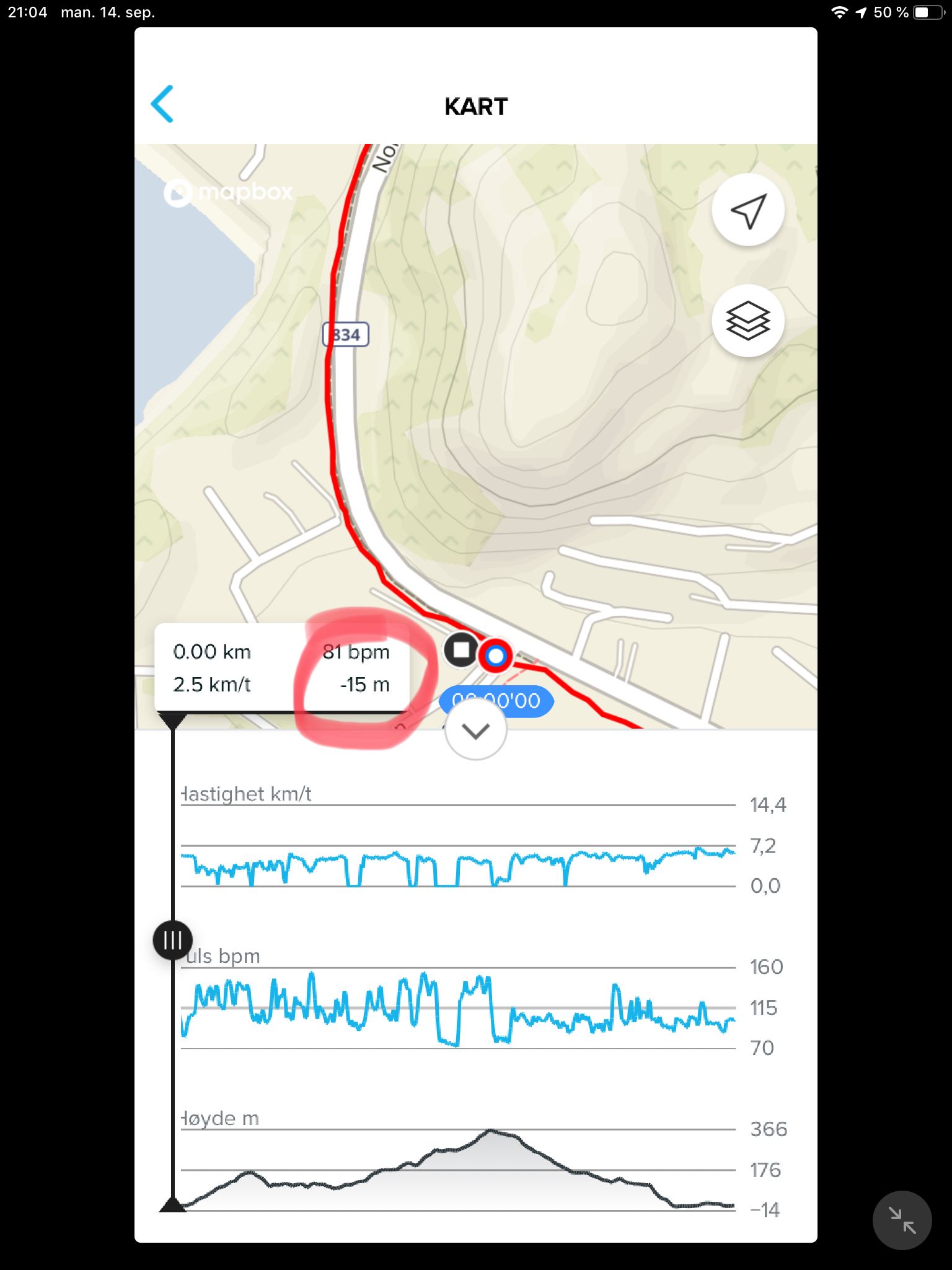
                                        When going to work this morning i calibrates manually to 4 masl, some minutes later checking in the office the watch displayed -25 meters.
                                        Now I did a auto calibration, left the watch 15 min with GPS fix. After the auto calibration the altitude fell with 25 meters/minute before it got stable again. The absolute air pressure differs with almost 15 hPA: 1005 on the watch and 1029 at the official weather station.
                                        Something is wrong here…

                                        Instagram: https://www.instagram.com/helgelandsbukken/
                                        https://www.instagram.com/suunto_adventures/
                                        IG: Helgelandsbukken, suunto_adventures
                                        Vimeo: vimeo.com/helgelandsbukken
                                        Blogg: https://turblogg.midnattsola.com

                                        J D E 3 Replies Last reply 17 Sept 2020, 06:44 Reply Quote 0
                                        • J Offline
                                          johann.fuehrer Bronze Member @Stefan Kersting
                                          last edited by johann.fuehrer 17 Sept 2020, 06:44

                                          @Stefan-Kersting Hello, if I remember correct, than the Baro reading is no the truth, as long as altitude and temperature ar not correct. This is because the pressure you read and is show is not the ambient pressure but calculated (by reading local pressure and do some maths) . Therefore in a plane on ground you set the local pressure!! by calibrating the altimeter to the real altitude of the airport and this pressure reading then should - but does not always - match you local weather station. Above a certain altitude you switch then by calibrating the altimeter by setting a specific PRESSURE and fly by flight levels which have a more or less undefined altitude due to the changing ambient pressure all over the world (weather i.e.)

                                          Confusing, isn’t it (some more headaches for @Dimitrios-Kanellopoulos and @Fenr1r 🙂

                                          S 1 Reply Last reply 17 Sept 2020, 06:53 Reply Quote 0
                                          43 out of 54
                                          • First post
                                            43/54
                                            Last post

                                          Suunto Terms | Privacy Policy

                                            This community forum collects and processes your personal information.
                                            consent.not_received