Real world data
-
I am also having bad spo2 values but also from my oxymeter ( medical). But not when I am inside with the airco, and not at 40c. Just an observation. I don’t know if spo2 can relate to heat. I read and searched a bit and heat it is said to significantly impact the spo2. If I am correct. Not trying to justify something and I am putting some feedback to suunto
Community Manager / Admin @Suunto
Creator of quantified-self.io - sync Garmin and COROS activities to Suunto, import Suunto routes, deliver Suunto routes to Garmin courses, and analyze training data in one private dashboard. -
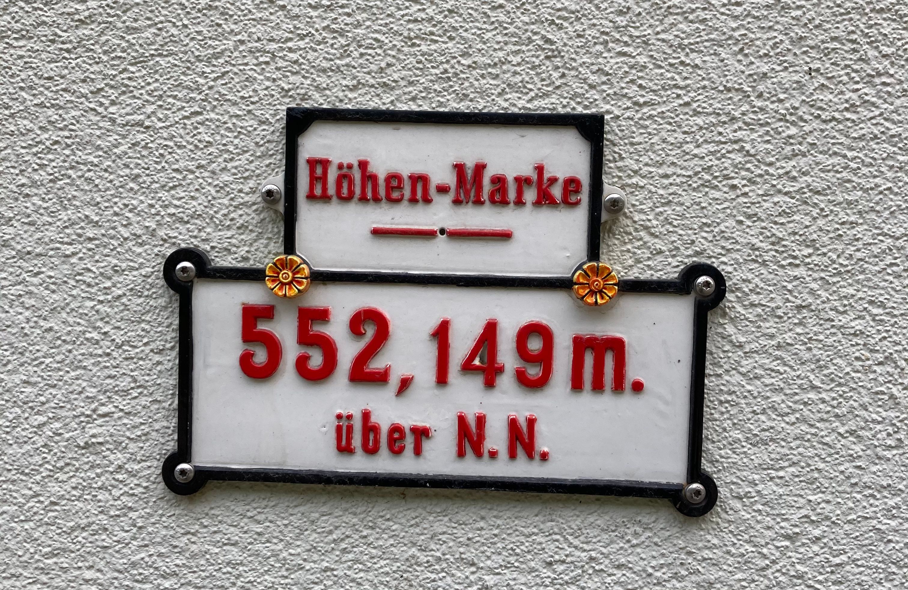
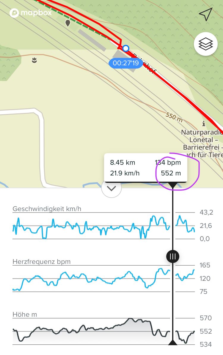
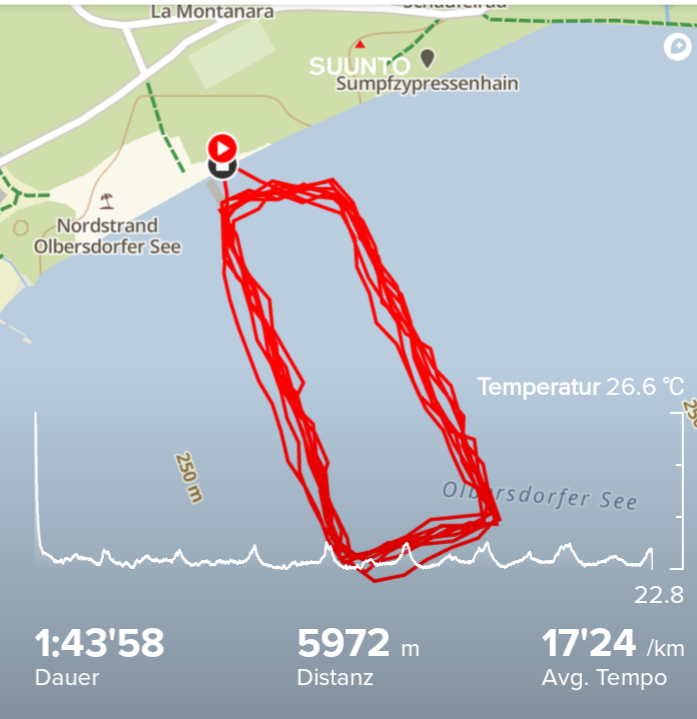
The S9P alltitude accuracy seems really great! Calibrated it once about a week ago and did a small trip to the local grocery store today. When passing an old railway station I took a picture of a sign on they Wall, which tells the altitude of the station. It was the same as measured by the S9P!
-
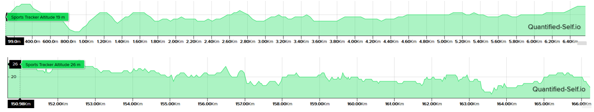
For those interested 185km ride with:
Suunto S9P
https://www.suunto.com/move/andrfaria640/60d7729dc2a2ac4a04baf5ec?imageId=60d77d4fc2a2ac4a04bb32fdGarmin edge 530 fw8.10 with decathlon hr strap
https://connect.garmin.com/modern/activity/7025695294Interesting the different altitude values and that s9p ended up with 61% battery !
-
@andré-faria whow very good trip
")
61 % is perfectly in line with 25 h autonomy prediction (4%/hour)
For elevation, you can upload the two activities gpx files to quantified-self.io if you want to see the elevation graph merged -
@andré-faria
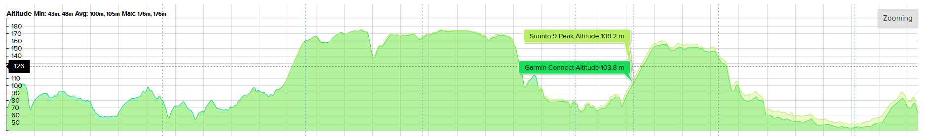
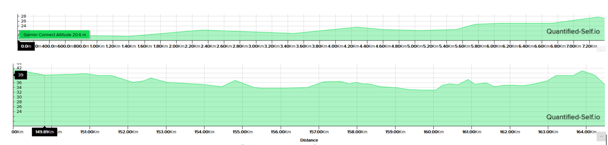
related to your S9 elevation concern, i did a smaller ride today, but I also noticed a difference between Suunto (509m in SA) and Garmin (573m in GarminConnect)Here is the route I followed
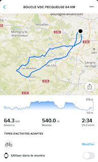
is shown 540m elev in SA, but 490 in QS )I merged the route, Garmin Edge and S9P activities route vs S9P vs Edge to see each activity towards the route’s elevation :
S9P Vs Garmin elevation:
S9P vs Route
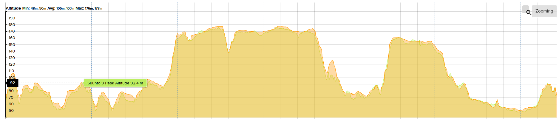
Garmin Edge vs route
Interesting thing is that in the first part S9P was lower and in the second part higher, when it started to rain, with a small depression
 (photo taken at 3 pm, ride at 10 pm)
So regarding the change in weather conditions, Garmin tends to deviate a little more from standard GPS elevation, as S9P remains always close. But surprisingly the total ascend of Garmin is closer to total route ascend than S9P total ascend.(if you send your gpx, maybe someone could help with the brilliant QS tool
) -
@chrisc92 said in Real world data:
@andré-faria
related to your S9 elevation concern, i did a smaller ride today, but I also noticed a difference between Suunto (509m in SA) and Garmin (573m in GarminConnect)Here is the route I followed
is shown 540m elev in SA, but 490 in QS )I merged the route, Garmin Edge and S9P activities route vs S9P vs Edge to see each activity towards the route’s elevation :
S9P Vs Garmin elevation:
S9P vs Route
Garmin Edge vs route
Interesting thing is that in the first part S9P was lower and in the second part higher, when it started to rain, with a small depression
(photo taken at 3 pm, ride at 10 pm)
So regarding the change in weather conditions, Garmin tends to deviate a little more from standard GPS elevation, as S9P remains always close. But surprisingly the total ascend of Garmin is closer to total route ascend than S9P total ascend.(if you send your gpx, maybe someone could help with the brilliant QS tool
)Thanks for this awesome comparison.
I don’t care too much about elevation differences. Sometime ago I followed the imense discutions about how each brand/site does…in the end what I got, is that there is no “right”.
On strava, the two guys that rode with me (one with Xiaomi phone) and other with hammerhead karoo 2 got for ascent 829m and 1044m respectively (against 977 from edge 530 and 660 from S9P)
But if anyone wants I can provide gpx, no problem. I posted this data, more to help the developments or people that need comparison of these devices.
What I posted before was a gravel ride, with some parts in “forest”.
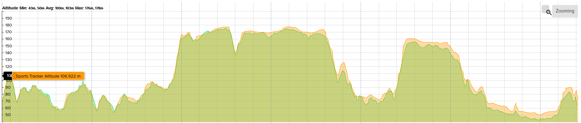
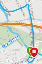
Today I did another 165km with both devices but on open road:Garmin 530 https://connect.garmin.com/modern/activity/7030987942 (458m ascent)
Suunto S9P https://www.suunto.com/en-be/move/andrfaria640/60d8a12f1c6b0f5222d3db2a (316m ascent)My collegues got 354m (xiaomi phone) and 452 (hammerhead karoo).
Based on what we climbed, I would say the suunto is right
Again, if someone needs/wants to compare, go ahead, I just cycled for Rapha Ambitious 220, to help creating awareness/funding for autism and for pleasure. -
@andré-faria Kudos for your ride and thank you for new data, I know that elevation is a neverending discussion subject, on measure and map processing concerns. Even a basic route gpx file can have different total ascent in SA, GCConnect and Strava route
Here is the merge of your two files (the X-offset is due to an offset of the starting point in QS)
S9P 316m ascent seems to be consistent for your loop.Considering the terrain where you performed your ride today, it is obvious that Garmin’s elevation is overrated towards the end, because yout took the same road for your first and last 7 kilometers !
the elevation pattern of Suunto is very consistent between the start and the end (although I should have reversed the curves)
whereas the Garmin pattern for the start/end path is really out of scope !
There is no need to discuss about that, the altitude should be the same for the first and the last kilometers, and Suunto shows a perfect consitency for that. Garmin overrated the elevation by almost 50% (confirmed by the route of your ride in Garmin Connect which was estimated to 335m elevation)
P.S.1 in QS @Dimitrios-Kanellopoulos I have a question in the import of Gpx files produced by GarminConnect : the starting point in QS is not the same as in the Garmin activity
 , as if the first points were not imported (for the SA activity merged at the right it is ok :
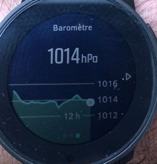
P.S.2 : another recent proof of Suunto barometer reliability :
Maybe did you hear about on the 24h elevation record attempt in June 5th by French athlete Matthis Granet ? 16632 m in 24h (mesured by a surveyor)
Suunto was 15677m, so 5-6% less -
@chrisc92 said in Real world data:
@andré-faria Kudos for your ride and thank you for new data, I know that elevation is a neverending discussion subject, on measure and map processing concerns. Even a basic route gpx file can have different total ascent in SA, GCConnect and Strava route
Here is the merge of your two files (the X-offset is due to an offset of the starting point in QS)
S9P 316m ascent seems to be consistent for your loop.Considering the terrain where you performed your ride today, it is obvious that Garmin’s elevation is overrated towards the end, because yout took the same road for your first and last 7 kilometers !
the elevation pattern of Suunto is very consistent between the start and the end (although I should have reversed the curves)
whereas the Garmin pattern for the start/end path is really out of scope !
There is no need to discuss about that, the altitude should be the same for the first and the last kilometers, and Suunto shows a perfect consitency for that. Garmin overrated the elevation by almost 50% (confirmed by the route of your ride in Garmin Connect which was estimated to 335m elevation)
P.S.1 in QS @Dimitrios-Kanellopoulos I have a question in the import of Gpx files produced by GarminConnect : the starting point in QS is not the same as in the Garmin activity
, as if the first points were not imported (for the SA activity merged at the right it is ok :
P.S.2 : another recent proof of Suunto barometer reliability :
Maybe did you hear about on the 24h elevation record attempt in June 5th by French athlete Matthis Granet ? 16632 m in 24h (mesured by a surveyor)
Suunto was 15677m, so 5-6% lessThanks a lot for doing this comparison.
Regarding initial point on Garmin, almost every device from Garmin I had (fenix 6s sapphire, fr245) had that issue. Only fr45 was more or less ok. I think it is very difficult to catch gps due to the buildings. But the edge said “gps ok” ahah -
O-See Open Water Race 5600m XTERRA, 8x700m, GPS+QZSS, the deviation of about 5% is ok, because I did not swim very straight.
-
@andré-faria said in Real world data:
Thanks a lot for doing this comparison.
Regarding initial point on Garmin, almost every device from Garmin I had (fenix 6s sapphire, fr245) had that issue. Only fr45 was more or less ok. I think it is very difficult to catch gps due to the buildings. But the edge said “gps ok” ahahNo it was not a garmin issue since the Garmin Connect is Ok just a small glitch in the comparison tool QS
GPS trace S9P and Garmin are very clode juste elevation is bad for garmin. -
second week S9P optical HR comparison
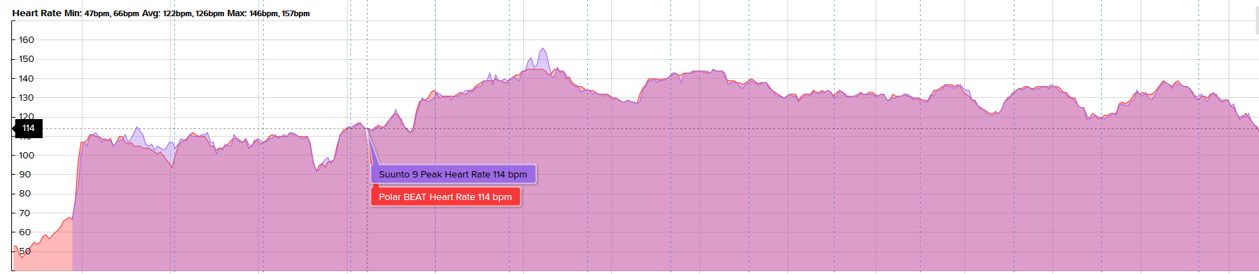
very good results today, the OHR is very reactive in pace change.Good positioning on the wrist, medium tightening, everything compared very well with belt strap despite sweat.
To avoid the “starting peak” I noticed on my previous test, as my run starts with an hill this can be misinterpreted by the firmware, I selected my activity 2 min before running (this is also good for GPS fixing)Only 2 small +10 peaks (1min), maybe I pushed the center button to heavily to navigate between displays
This curve is very promising and i think I will entirely rely onthe OHR in a few weeks -
@chrisc92 keep in mind that Garmin connect has HUGE lines for tracks. Also snap to road exists check that it’s not checked.
Qs does nothing than to show the data. However a glitch can exist in the fit export although I doubt it if not modified by some source even Garmin connect.
-
@dimitrios-kanellopoulos I noticed several times, garmin imported routes add an offset in QS because of missing imported points. (same file imported in SA shows the good starting point)
-
@chrisc92 do you have an example for me ?
-
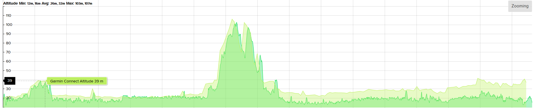
the QS merge of initial data from @André-Faria saved as GPX routes
-
Garmin 530 https://connect.garmin.com/modern/activity/7030987942 (458m ascent) saved as a GC route
-
Suunto S9P https://www.suunto.com/en-be/move/andrfaria640/60d8a12f1c6b0f5222d3db2a (316m ascent) saved as a SA route
-
-
@chrisc92 I think its the save as route. Using the original files this should not be an issue.
Just for the sake of it, QS just reads the points. If there is a glitch that should come from the source of it.
-
@dimitrios-kanellopoulos maybe you know how to export a gpx from SA or GC someone else activity ? I could just save the activity as routes.
So I imported The Garmin route in SA in this gpx file where I do not see the glitch.
then in QS import SA route GPX into QS is ok
but import Garmin route GPX into QS has a glitch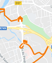
so the translation of Garmin GPX by SA went Ok.
Gpx is a very simple xml text file with lines of GPS and elev data<rtept lat=“50.652588” lon=“3.0599594”><ele>23.4</ele>
I don’t understand how the first lines are not displayed when direct import from Garmin i will try to search for a gpx comparison tool
-
@chrisc92 I see the issue. You are right.
-
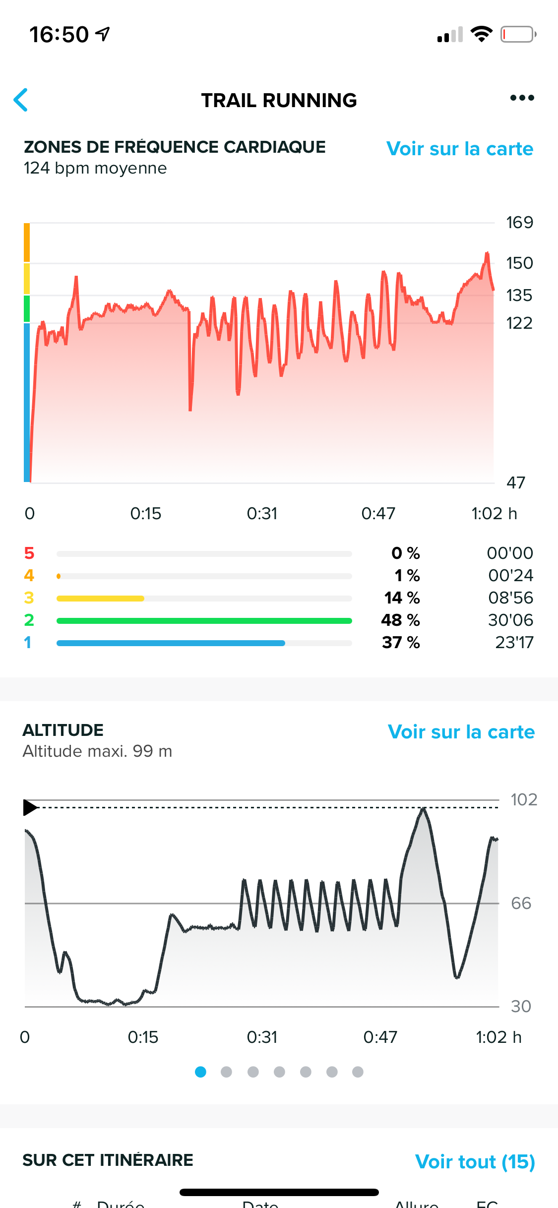
to compare, here are two similar short uphill sessions in the same spot with S9P
the first one with the HR belt
the second with the OHR
it is clear that with the OHR the frequency does not rise.
i say that the effort is about 30-35 seconds and that the recovery was very slow.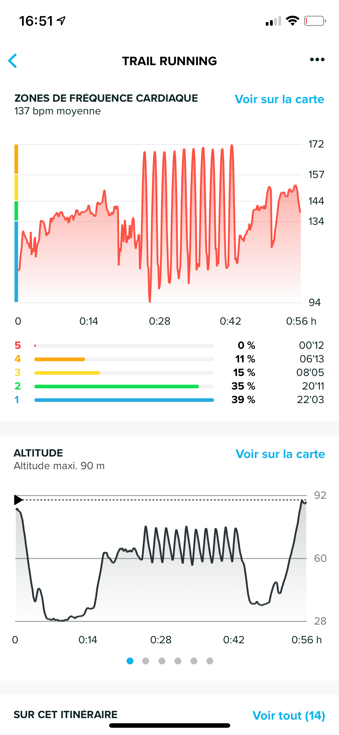
-
Does anyone have any examples or comparisons for walking / Hiking / trekking with HR Belt and OHR, for me personally that is the most likely activity type / scenario I would use the OHR rather than the belt. I would almost always use a belt when undertaking any other activity.
I currently have the S9B and the OHR for walking is terrible so would be very interested to understand how the peak’s OHR performs.
Many Thanks
Hello! It looks like you're interested in this conversation, but you don't have an account yet.
Getting fed up of having to scroll through the same posts each visit? When you register for an account, you'll always come back to exactly where you were before, and choose to be notified of new replies (either via email, or push notification). You'll also be able to save bookmarks and upvote posts to show your appreciation to other community members.
With your input, this post could be even better 💗
Register Login