Suunto app Forum Suunto Community Forum
    • Recent
    • Tags
    • Popular
    • Users
    • Groups
    • Register
    • Login

    Subterranean outdoor activities with Galileo

    Scheduled Pinned Locked Moved Suunto 5
    22 Posts 5 Posters 1.4k Views 5 Watching
    Loading More Posts
    • Oldest to Newest
    • Newest to Oldest
    • Most Votes
    Reply
    • Reply as topic
    Log in to reply
    This topic has been deleted. Only users with topic management privileges can see it.
    • Łukasz SzmigielŁ Offline
      Łukasz Szmigiel @DMytro
      last edited by

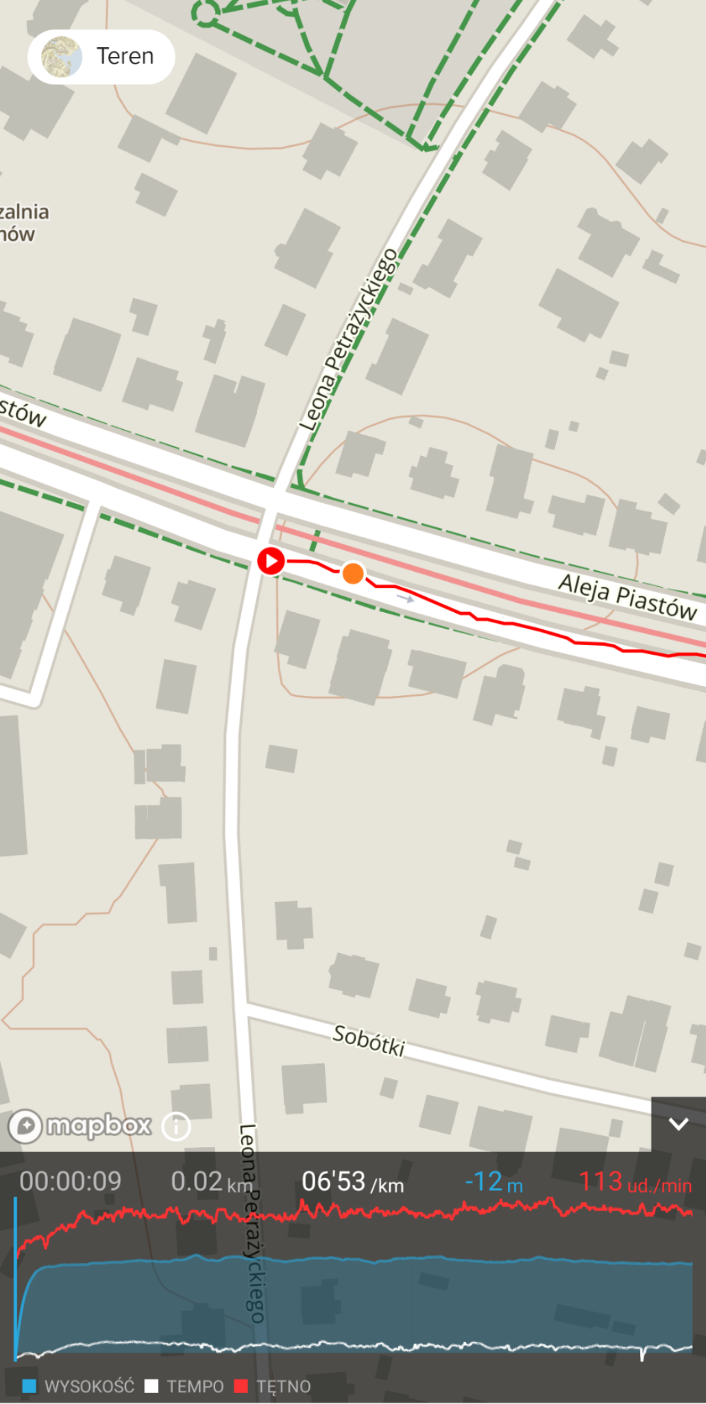
      @dmytro I usually wait a little longer or start running without actually starting the workout and it’s mostly OK but it goes bonkers from time to time (like today). I thought that this problem was sorted out but maybe not?

      S9PP 2.40.44

      DMytroD 1 Reply Last reply Reply Quote 0
      • DMytroD Offline
        DMytro @Łukasz Szmigiel
        last edited by

        @łukasz-szmigiel I didn’t thought of it as a problem tbh. It’s just that GPS needs time to settle and the arrow turns green not when the signal is great but when it’s good enough.

        Łukasz SzmigielŁ 1 Reply Last reply Reply Quote 0
        • Łukasz SzmigielŁ Offline
          Łukasz Szmigiel @DMytro
          last edited by

          @dmytro yeah it might be a matter of how it’s tuned in to show that the signal is good enough (and it doesn’t care about VDOP) but I haven’t seen it with other GNSS which is strange. Or maybe I’m not using other GNSS often enough to notice?

          S9PP 2.40.44

          Tomas5T DMytroD 2 Replies Last reply Reply Quote 0
          • Tomas5T Offline
            Tomas5 @Łukasz Szmigiel
            last edited by Tomas5

            @łukasz-szmigiel i don’t have problem with altitude at all or at least i didn’t notice. For example from last bike. But i every time wait for GPS signal befor starting excercise. And it took usually longer. Around 20-30 seconds sometimes less or more. Maybe you just need to wait few seconds more before starting excercise.
            F1CB55B6-D649-4B8B-B131-44CF49340D00.jpeg
            And latest hike:
            17DEB04C-3724-41E5-8E89-F0BBF877BD52.jpeg

            1 Reply Last reply Reply Quote 1
            • DMytroD Offline
              DMytro @Łukasz Szmigiel
              last edited by

              @łukasz-szmigiel I use Galileo and it’s there every time I rush the wait. I’ll try other combinations out of interest.

              Tomas5T 1 Reply Last reply Reply Quote 0
              • Tomas5T Offline
                Tomas5 @DMytro
                last edited by

                @dmytro i use galileo too.

                1 Reply Last reply Reply Quote 0
                • Łukasz SzmigielŁ Offline
                  Łukasz Szmigiel
                  last edited by

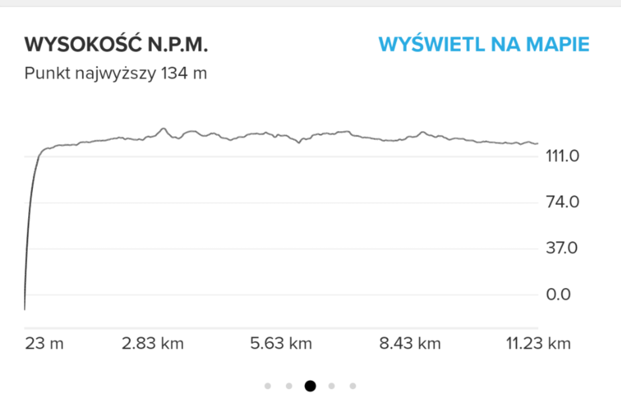
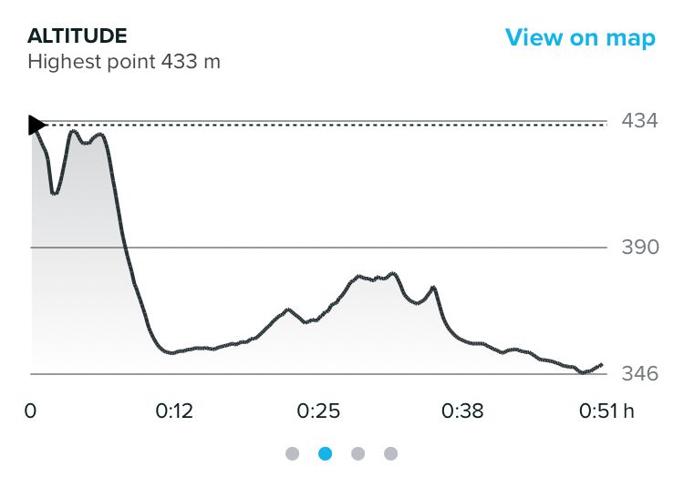
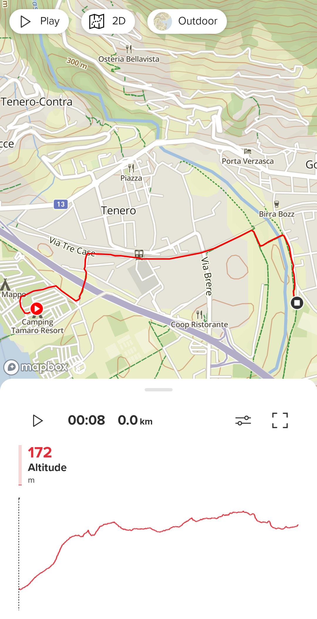
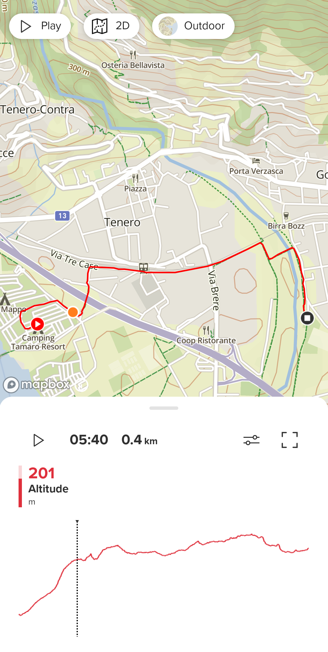
                  Just a friendly reminder that a gigantic drop of altitude at the beginning of the activity is still there, mostly when using two GNSS, oftentimes Galileo. This is very frustrating, especially now when we have a brand new ascent / descent algorithm. Any chances it’s going to get fixed?

                  S9PP 2.40.44

                  Tomas5T 1 Reply Last reply Reply Quote 1
                  • Tomas5T Offline
                    Tomas5 @Łukasz Szmigiel
                    last edited by Tomas5

                    @łukasz-szmigiel did’t tried it yet with new firmware but since you mentioned it last time. I was looking at this and i have this issue too. Not every time but usualy it is few tenths or even hundreds meters. But there are some exceptions without any altitude drop. I use gps + galileo all the time. If weather stay good i will report tomorrow test with latest firmware. And in my case it starts on higher altitude and then drops down to real altitude. I just noticed you have it in oposite direction.

                    Łukasz SzmigielŁ 1 Reply Last reply Reply Quote 0
                    • Łukasz SzmigielŁ Offline
                      Łukasz Szmigiel @Tomas5
                      last edited by

                      @tomas5 it typically drops from too high, approx 70 - 90 meters during first 30 - 60s of workout

                      S9PP 2.40.44

                      Tomas5T 1 Reply Last reply Reply Quote 0
                      • Tomas5T Offline
                        Tomas5 @Łukasz Szmigiel
                        last edited by

                        @łukasz-szmigiel i been on bike today, no issue with altitude drop at begining. But before i pressed start i was waiting for another minute after green gps icon apeared because i was setting up navigation and suunto plus feature.

                        Łukasz SzmigielŁ 1 Reply Last reply Reply Quote 0
                        • Łukasz SzmigielŁ Offline
                          Łukasz Szmigiel @Tomas5
                          last edited by

                          @tomas5 this is well known. Although I’d like to know whether I should wait for ten more seconds or two more minutes.

                          S9PP 2.40.44

                          freeheelerF 1 Reply Last reply Reply Quote 1
                          • freeheelerF Offline
                            freeheeler @Łukasz Szmigiel
                            last edited by

                            @łukasz-szmigiel
                            it is the first time I see it that obvious since the campground is really flat.
                            in this case, yes it would be helpful to distinguish between satellite lock and “altitude lock” 🙂

                            Screenshot_20220417-140351~2.png

                            Screenshot_20220417-140335~2.png

                            living sideways

                            isaziI 1 Reply Last reply Reply Quote 0
                            • isaziI Offline
                              isazi Moderator @freeheeler
                              last edited by

                              @freeheeler for activities shorter than 15 minutes the issue is that fusedalti may not kick in.

                              Watch: Suunto Vertical Ti

                              Blog: isazi's home

                              freeheelerF 1 Reply Last reply Reply Quote 1
                              • freeheelerF Offline
                                freeheeler @isazi
                                last edited by

                                @isazi
                                I know, it was around 30mins

                                living sideways

                                Tomas5T 1 Reply Last reply Reply Quote 1
                                • Tomas5T Offline
                                  Tomas5 @freeheeler
                                  last edited by

                                  Today on bike i didn’t have problem with altitude at beginning. But it is funny that lowest point is 375m, highest point is 979m. But my ascent is only 557m which is less than difference between lowest and highest point. By suunto app map planer it should be around 800m. But without barometer i don’t have big expectations from this measurement.

                                  Łukasz SzmigielŁ isaziI 2 Replies Last reply Reply Quote 0
                                  • Łukasz SzmigielŁ Offline
                                    Łukasz Szmigiel @Tomas5
                                    last edited by

                                    @tomas5 I don’t expect it to be perfect. I just want to know when to start the activity 😄 my experience when trekking is that I usually get 1 - 3m error in altitude when checking on marked peaks, with S5 and Galileo. And I find it remarkable.

                                    S9PP 2.40.44

                                    1 Reply Last reply Reply Quote 0
                                    • isaziI Offline
                                      isazi Moderator @Tomas5
                                      last edited by

                                      @tomas5 yes depending on the route itself you may see less ascent with baroless devices because of the 7m threshold.

                                      Watch: Suunto Vertical Ti

                                      Blog: isazi's home

                                      Tomas5T 1 Reply Last reply Reply Quote 2
                                      • Tomas5T Offline
                                        Tomas5 @isazi
                                        last edited by

                                        @isazi yes probably this reason, when i checked altitude against marked peaks I have same result as @Łukasz-Szmigiel usually few meters difference, only rarely few tens of meters.

                                        Tomas5T 1 Reply Last reply Reply Quote 0
                                        • Tomas5T Offline
                                          Tomas5 @Tomas5
                                          last edited by

                                          I started to commute to work on bike sometimes. As i don’t have time at morning, i wait just for green icon to appear and last two rides i started at 450 altitude but graphs started on around 700 and dropped in few minutes. Now this issue starts to be more obvious for me.

                                          Is there any feature request i can vote for to fix this issue at least in app after sync ?

                                          freeheelerF 1 Reply Last reply Reply Quote 3
                                          • freeheelerF Offline
                                            freeheeler @Tomas5
                                            last edited by

                                            @tomas5
                                            I support this feature request! we should be informed if

                                            1. the satellites are locked
                                            2. the precision is good enough to get the correct altitude (for baro versions also with FusedAlti)

                                            I have made various observations regarding start altitude but also alti change during an activity on a totally flat track, that I can not explain. It would be good to do some improvements here, or let’s say to inform the user by GUI improvements about the status of the watch.

                                            living sideways

                                            1 Reply Last reply Reply Quote 5
                                            • First post
                                              Last post

                                            Suunto Terms | Privacy Policy