Maps Partial Update Rollout, July 2025 [Limited Countries]
-
@pilleus Why are you telling me all this? I just pointed out that the mentioned part of your post was totally wrong.
-
@Egika said in Maps Partial Update Rollout, July 2025 [Limited Countries]:
Suunto is currently working on this.
I don’t meant to be boring, but hope that someone is also working on checking the map accuracy.
As already reported, the SA seems to be using a layer of OSM that contains a lot of artefacts:
SA on left and, OSM with “Cycle map” layer on the centre (showing both the same wrong feature), and the OSM with “Tracestrack Topo” on the right, which shows the correct topography: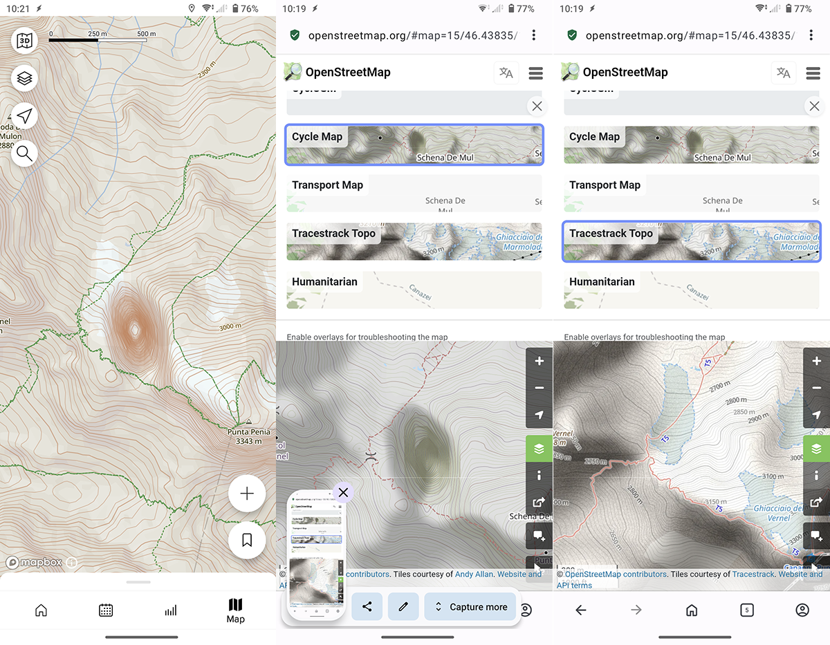
The Dolomite area is full of this kind of errors (read: fake depressions), which are present only on the “Cycle Map” OSM layer. In some places these artefacts completely distort the real topography, causing the maps shown by SA to be wildly inaccurate.
-
I’ll quickly comment on some raised issues, but if you want to continue discussion on any of it - please create separate topic.
- Limited update schedule. Due to cost/resource/validation reasons. Known and should be improved in the future.
- Inconvenience of region selection for some countries, especially as a destination. Known, hopefully will have graphical way to select in the future.
- Elevation contours is not perfect in some places? This is a complex subject. Suunto uses globally available digital elevation models (DEM) for watch maps, Suunto App uses Mapbox data (no idea what exact elevation model do they use, but anyway it’s not related to watch maps updates). While improving elevation model (specifically for route building) is important topic we’re unlikely to have resources to verify and fix specific places everywhere in the world.
Again, please here comments only related to the update. If you have any suggestions or issues you want to report - it should be in the dedicated topic, existing or new.
Opinions expressed are solely my own and do not express the views or opinions of my employer
-
Sorry for capturing your thread with this discussion. May be you can move it to a new topic. 🫣
-
@pavel.samokha said in Maps Partial Update Rollout, July 2025 [Limited Countries]:
This is a complex subject. Suunto uses globally available digital elevation models (DEM) for watch maps, Suunto App uses Mapbox data (no idea what exact elevation model do they use, but anyway it’s not related to watch maps updates).
it is definitely odd for me that watch and SA have different map sources, since they are parts of the same ecosystem: a Suunto user draw a route in SA and then send it to the watch, but nobody can tell if the maps shown by the two (watch and SA) are the same in that area … WOW(1)!
While improving elevation model (specifically for route building) is important topic we’re unlikely to have resources to verify and fix specific places everywhere in the world.
none at Suunto cares if thousand of his costumers by opening the SA will find wrong maps in one of the most frequented area along the Alps … WOW(2)!
I don’t think that this is good for the Suunto’s reputation, but if this the policy of the company I surrender, will no more bother the forum about that.
Sorry for the OT.
-
@Stefano-M64 said in Maps Partial Update Rollout, July 2025 [Limited Countries]:
@pavel.samokha said in Maps Partial Update Rollout, July 2025 [Limited Countries]:
While improving elevation model (specifically for route building) is important topic we’re unlikely to have resources to verify and fix specific places everywhere in the world.
none at Suunto cares if thousand of his costumers by opening the SA will find wrong maps in one of the most frequented area along the Alps … WOW(2)!
Sorry for the OT.
Still OT, but this is clearly not what Pavel wrote.
Not caring for map accuracy in a busy place in the Alps is definitely not the same as not being able to fix specific places everywhere in the world.
Please don’t reframe the statement into something else you can then be upset about.
Thx! -
@Egika said in Maps Partial Update Rollout, July 2025 [Limited Countries]:
Still OT, but this is clearly not what Pavel wrote.
I apologize, didn’t want to be unkind or “reframe” what Pavel stated.
the plain fact is that the maps provided by Mapbox are proved to be (very) wrong in some areas and that is - in my opinion - a problem for Suunto and its costumers. We are no more in the old times when maps were drawn by hand and then often very approximate, nowdays people are used to completely rely on them, wrong maps should not exist.
-
Hy everyone! Is there a way to know at which interval contour lines are plotted for each map zoom level?
I mean, e.g. at the 1km zoom level of the map, are contour lines plotted every 25m or evey 50m? Same applies when I change zoom level.
This could be helpful to roughly get some elevations in the nearby of where I’m hiking, e.g. to decide the most appropriate path to follow -
Hi all,
I seing some deviations on the contour lines on the map with the reality and I digged a bit about it.
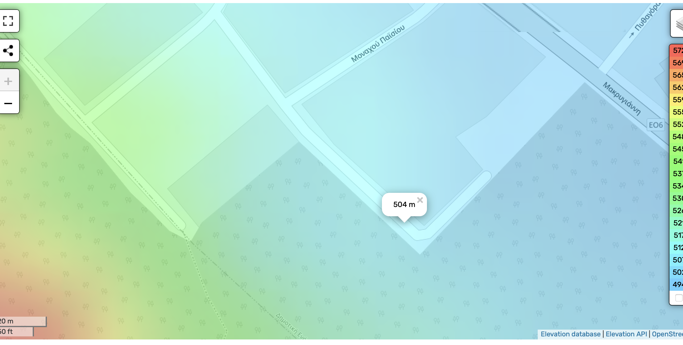
It seems that the app (and the watch) at times, has inconsistent data with the current OpenStreetMap data in terms of altitude indicators.As an example I checked on the measurement of a POI I am doing some construction work and I know the altitude because of the topographic measurement being 504m.
Suunto Vertical calculated it (biking there) at 513m,
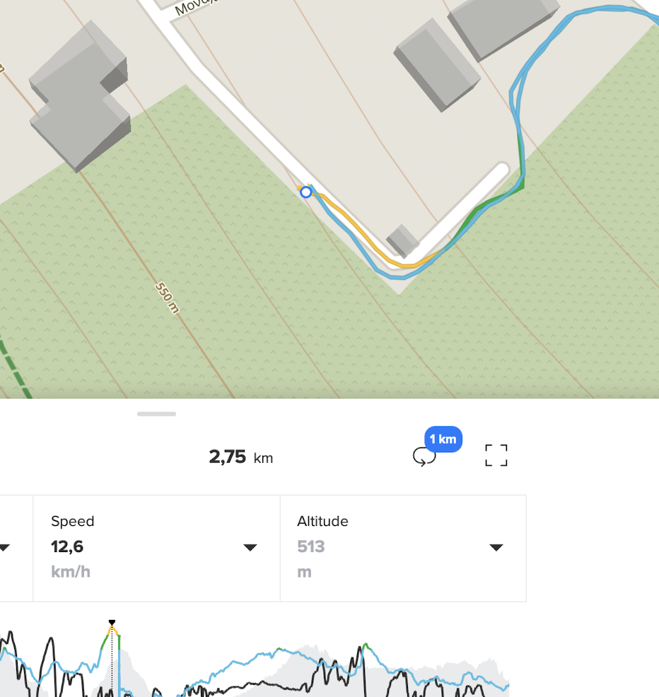
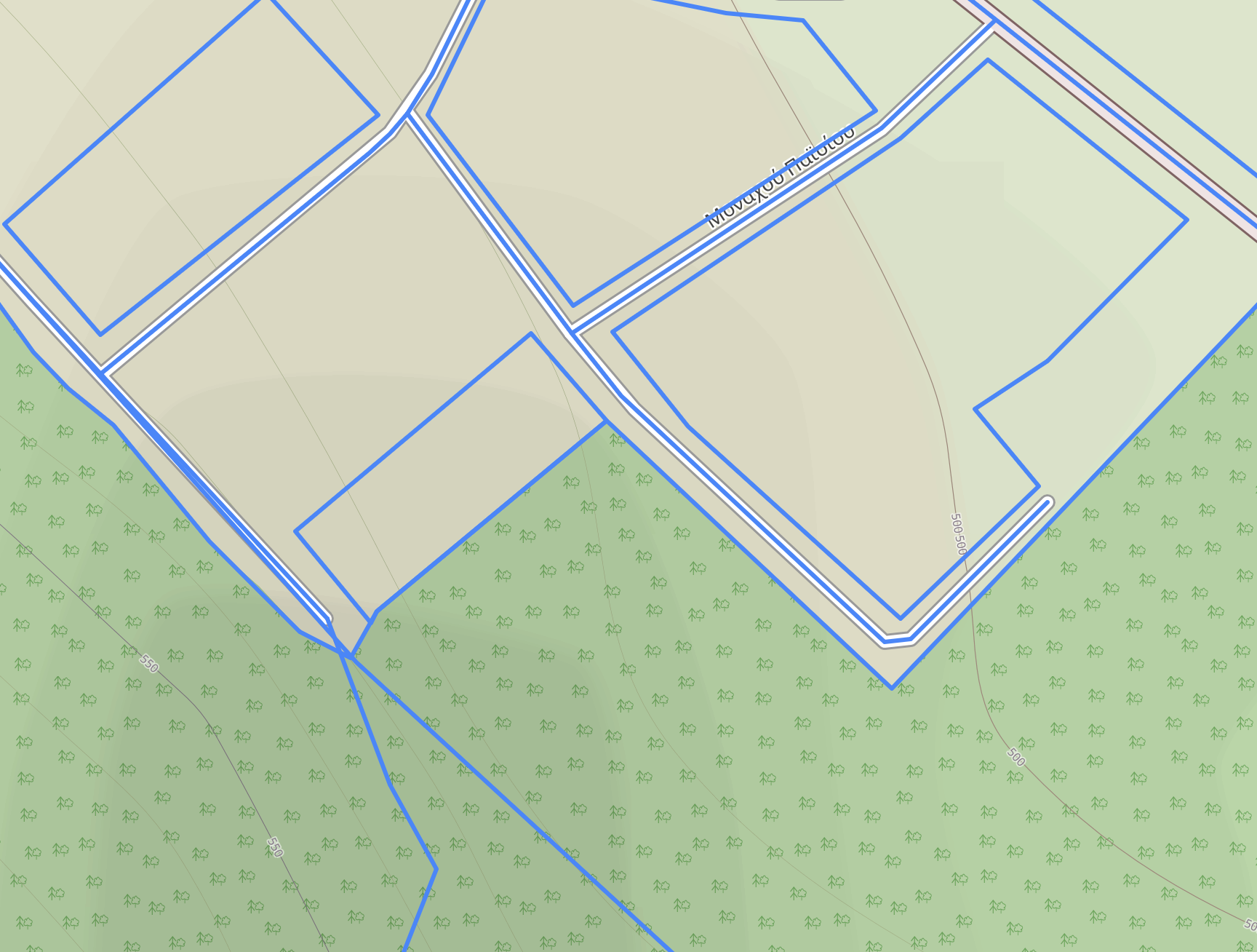
OpenstreetMap on the Suunto app shows the contour being ±530 (see screenshot)
OpenstreetMap on their site shows a different picture with the contour lines being significantly different to suunto’s (and strava) data and quite accurate to ~504m
I then tested the measurement of my Apple Watch ultra at the topographic point which was spot on at 505m (on my wrist)
-
@thanasis
As far as I know, contour lines are a dedicated layer on each and every map, and the source of its data can be multiple.
Suunto uses map box maps, based on OSM data for the content but maybe not for the contour lines (aka altitude sources), OSM itself doesn’t have these data and is drawing contour lines from…
Some offline maps used by some other apps are using third party altitude data to draw their own contour lines (like openandromaps using sonny lidar data).
After that, there is the drawing and the data used behind for the routing and calculation… -
@Mff73 said in Maps Partial Update Rollout, July 2025 [Limited Countries]:
@thanasis
As far as I know, contour lines are a dedicated layer on each and every map, and the source of its data can be multiple.
Suunto uses map box maps, based on OSM data for the content but maybe not for the contour lines (aka altitude sources), OSM itself doesn’t have these data and is drawing contour lines from…
Some offline maps used by some other apps are using third party altitude data to draw their own contour lines (like openandromaps using sonny lidar data).
After that, there is the drawing and the data used behind for the routing and calculation…OK thanks for that. In this case the map box maps are somehow off . I also checked measurements in other POIs of the city and indeed that data seem a bit off as well.
so i guess that there isn’t much that one can do or expect in this regard right?
-
@thanasis said in Maps Partial Update Rollout, July 2025 [Limited Countries]:
OK thanks for that. In this case the map box maps are somehow off.
so i guess that there isn’t much that one can do or expect in this regard right?
Sadly they are not as good as one would expect, and being one of the most prominent features of the new models, that’s very disappointing… inaccurate maps should not exist in 2025
-
@pavel.samokha said in Maps Partial Update Rollout, July 2025 [Limited Countries]:
Limited update schedule. Due to cost/resource/validation reasons.
Sorry to bring this up again, but does this imply that we shouldn’t expect updates for other regions any time soon? I think we’re coming up on 2 years since my region was updated. There are quite a few trail networks that are out-of-date on the watch maps.
@pavel.samokha said in Maps Partial Update Rollout, July 2025 [Limited Countries]:
Known and should be improved in the future.
Any thoughts on when this future is? Kinda seems like Suunto prepped all the maps for the Vertical release and then
completely forgot aboutdeprioritized updating anywhere outside of UTMB regions.Hopefully the future is soon-ish. I don’t know exactly how Suunto’s map update process works, but it is possible to create a system that updates from OSM info on a daily basis. BBBike does this for Garmin maps.
-
@duffman19 maps ofc will be updated, but I can’t provide you a timeframe
Opinions expressed are solely my own and do not express the views or opinions of my employer
-
@pavel.samokha Yes, please. I contribute to OSM, and regular updates would motivate me to edit more often.
-
@pavel.samokha
Is there any hope that the Balkans will get back the contour lines above the 200 m limit anytime soon? I’m really struggling to understand why some regions get this but others don’t. This has now been going on for years, and I tend to buy a new watch every 2-3 years. So it spans the entirety of this watch’s lifetime with me. Why do some regions get better treatment regarding maps? Should this be presented to buyers so they know that, depending on the region they live in, some features could not work as expected?I love Suunto ecosystem and build quality, but I’m not sure I’d accept this limitation on my next watch TBH.
-
P pavel.samokha unpinned this topic