-
@Dimitrios-Kanellopoulos No i don’t have a baro
-
@Ashish-Nautiyal sorry I was confused because you mentioned calibrated. What do you mean with that?
Community Manager / Admin @Suunto
Creator of quantified-self.io - sync Garmin and COROS activities to Suunto, import Suunto routes, deliver Suunto routes to Garmin courses, and analyze training data in one private dashboard. -
@Dimitrios-Kanellopoulos Yikes. I am sorry. Yeah please ignore the compass related comment. I meant trying with GLONASS and without it. But irrespective of that i always find my elevation readings to be way off than everyone else i am running with.
-
@Ashish-Nautiyal Do the charts/graphs look alike to others? IT is only the ascent/descent different?
Community Manager / Admin @Suunto
Creator of quantified-self.io - sync Garmin and COROS activities to Suunto, import Suunto routes, deliver Suunto routes to Garmin courses, and analyze training data in one private dashboard. -
@Dimitrios-Kanellopoulos Yes the map looking similar to others. Only the ascent value is different.
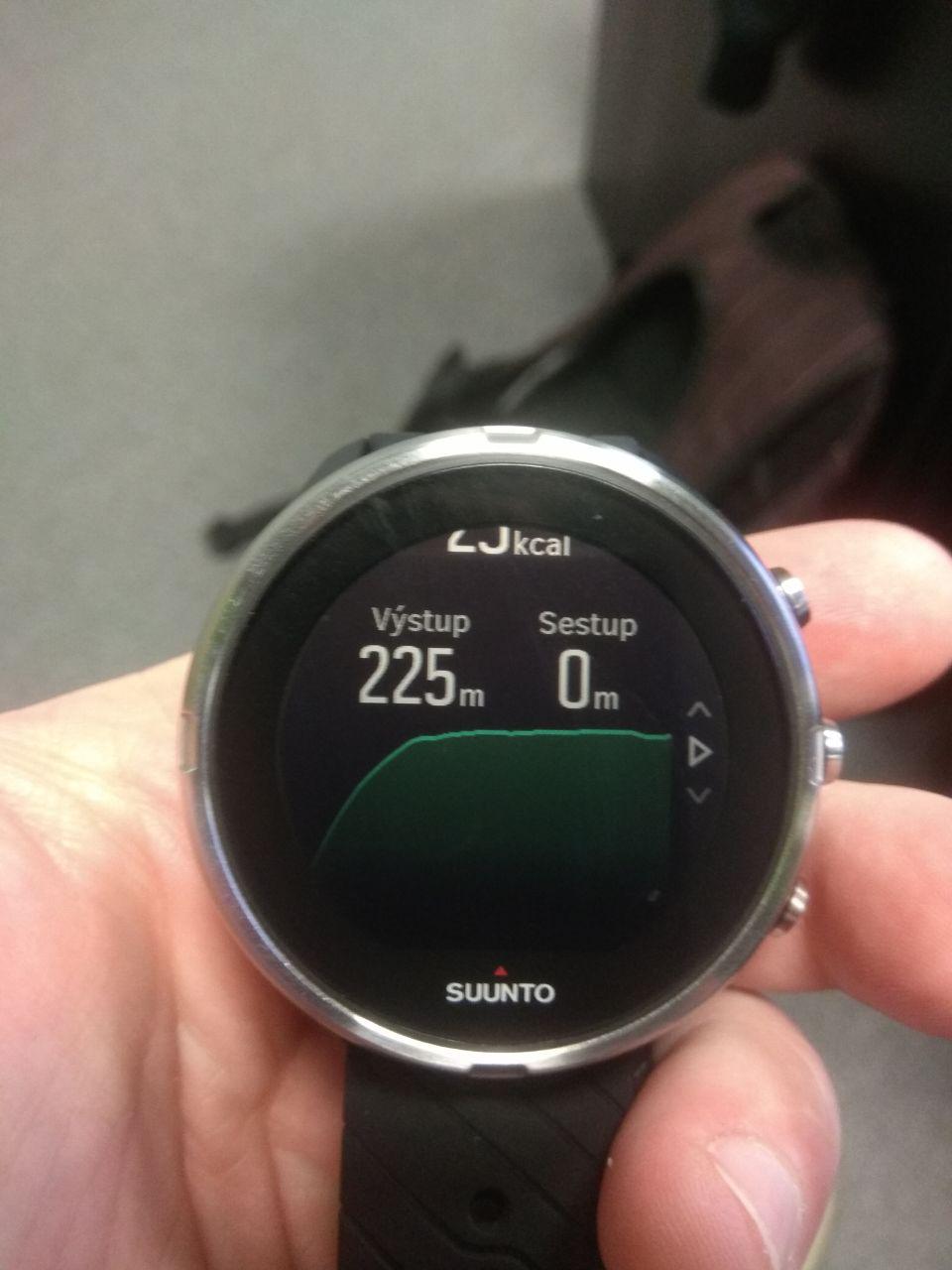
One of the reasons i posted on this topic is that I have noticed that in my ascent graph i always see a spike (increase in ascent or descent) right at the start (within a mile) of the run. So based on this discussion, i am thinking that may be my watch gps is not actually getting locked even though it shows green. -
@Ashish-Nautiyal no I know what it is. Do other service if you correct the ascent report a correct value for ascent?
Suunto uses a ±7m filer change for non-baro devices to avoid GPS problems.
Why 7? No clue I just asked.
On baro devices that number is 3 meters that works quite file imo. Remember that 1m change can happen with your hand swing only for example. ITs a complicated matter but well…
Community Manager / Admin @Suunto
Creator of quantified-self.io - sync Garmin and COROS activities to Suunto, import Suunto routes, deliver Suunto routes to Garmin courses, and analyze training data in one private dashboard. -
@Dimitrios-Kanellopoulos Yes so if i try to correct elevation in strava, it will bring it back to what i see with others (and its not that the other runners have just garmin or non-Suunto watch, some of them uses Suunto Ambit and haven’t faced any issue like mine).
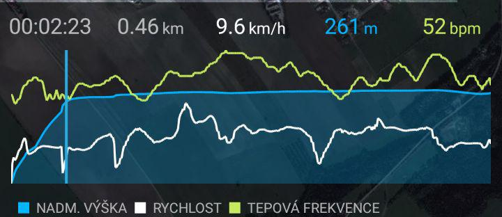
What you mention does makes sense, although last week for my 40mile bike ride i got a difference of 500ft (which does seems really huge). Also it just feel awkward that i have to correct elevation after every activity.I tried something different for my today’s run. The activity didn’t uploaded automatically, so i exported the .tcx file and uploaded to strava.
Here is the link to my movescount and strava for the activity:
http://www.movescount.com/moves/move281124895
https://www.strava.com/activities/2296968004I didnt even have to correct the elevation it automatically came to what i expected it to be. There is difference of almost 200ft between what movescount and strava shows for the same activity. Does Suunto treat Ascent info different than other services?
-
@Ashish-Nautiyal the tcx format does not contain the ascent headers neither the fit from movescount unfortunately. Suunto apps sends the correct headers. Makes sense?
Community Manager / Admin @Suunto
Creator of quantified-self.io - sync Garmin and COROS activities to Suunto, import Suunto routes, deliver Suunto routes to Garmin courses, and analyze training data in one private dashboard. -
@Dimitrios-Kanellopoulos Ohk, so strava basically calculated the elevation gain there. Thanks for making some things clear to me. I still thing its odd to go through this lengthy process to find actual elevation gain, but i appreciate your help
")
-
@Dimitrios-Kanellopoulos the ±7m may come from the 15m radius of GPS accuracy perhaps ( i.e. https://lembergsolutions.com/blog/gps-accuracy-complete-guide-dummies ) but I remeber that vertically the accuracy is worse ( you see more satellites BESIDES your position than ABOVE your position and steeper angles to the source multiply the error, or something like that)…
Edit: I have to explain it better: for having a great HORIZONTAL position determined, the best thing would be to have the GPS satellites on the same horizontal plane you are, but somewhere spread around your positon in all directions (north, south, east, west…).
For a great VERTICAL position, as many satellites as possible direct above your position (this wont ever happen") )would get the best to get the most accurate height (waighted average of all satellites).
)would get the best to get the most accurate height (waighted average of all satellites). -
@Ashish-Nautiyal yeah let me also give you more info np.
So here is how it goes:
- your watch altitude profile most probably and most of the times should be ok. It can get funky the worse the conditions get. GPS altitude is basically based on ping times afaik.
- Once you have the data you can calculate ascent with several ways, add filters and so on.
- That value is supported into .fit fomat mostly and some services even override that when you sync and do their own magic. Of course, if that is missing the service should calculate it anyway. That applies for eg to Strava as Movescount does not export the ascent/descent values.
- Several services allow you to recalculate the ascent/descent and more data from the “data”, that the fit file contains.
To be honest, it would be great if SA allowed you to do that. Like strava does.
Or allow the user to set the filter.I hope it helps.
-
BTW perhaps this plays a factor. The GPS system. GLONASS on/off.
-
or anything new coming hopefully
Hello! It looks like you're interested in this conversation, but you don't have an account yet.
Getting fed up of having to scroll through the same posts each visit? When you register for an account, you'll always come back to exactly where you were before, and choose to be notified of new replies (either via email, or push notification). You'll also be able to save bookmarks and upvote posts to show your appreciation to other community members.
With your input, this post could be even better 💗
Register Login