Suunto app Forum Suunto Community Forum
    • Recent
    • Tags
    • Popular
    • Users
    • Groups
    • Register
    • Login

    Continued Incorrect Ascent Readings

    Scheduled Pinned Locked Moved Suunto 9
    38 Posts 8 Posters 1.9k Views
    Loading More Posts
    • Oldest to Newest
    • Newest to Oldest
    • Most Votes
    Reply
    • Reply as topic
    Log in to reply
    This topic has been deleted. Only users with topic management privileges can see it.
    • Dimitrios KanellopoulosD Offline
      Dimitrios Kanellopoulos Community Manager @zvonejan
      last edited by

      @zvonejan no you are absolutely right. Not only for that sport of course. If I recall correct (will check that for you) the track and field mode has that set for you. Of course to have some customization (ability to select) is welcome. I wont argue.

      That said, have you used the track and field mode and got asc/desc values ?

      Community Manager / Admin @Suunto
      Creator of Quantified-Self.io
      youtube.com/c/dimitrioskanellopoulos
      https://instagram.com/dimitrioskanellopoulos
      https://www.strava.com/athletes/7586105

      zvonejanZ 1 Reply Last reply Reply Quote 0
      • mario_bM Offline
        mario_b @Nick Vlahandreas
        last edited by

        @Nick-Vlahandreas what does the ascent/descent values look like in the watch? when you review the activity? do you see the same?

        Dimitrios KanellopoulosD 1 Reply Last reply Reply Quote 0
        • Dimitrios KanellopoulosD Offline
          Dimitrios Kanellopoulos Community Manager @mario_b
          last edited by

          @mario_b I checked it for him yes they are the same.

          Community Manager / Admin @Suunto
          Creator of Quantified-Self.io
          youtube.com/c/dimitrioskanellopoulos
          https://instagram.com/dimitrioskanellopoulos
          https://www.strava.com/athletes/7586105

          mario_bM 2 Replies Last reply Reply Quote 1
          • mario_bM Offline
            mario_b @Dimitrios Kanellopoulos
            last edited by

            @Dimitrios-Kanellopoulos ah ok. i think the .fit file would be nice. another test would be choosing (just for testing) running while mountain biking. if that would not count the small up’s and downs, so it would only be a problem with the calculation under the mountain biking profile/app/sport activity.

            1 Reply Last reply Reply Quote 0
            • mario_bM Offline
              mario_b @Dimitrios Kanellopoulos
              last edited by

              @Dimitrios-Kanellopoulos looking at the jumps i think with the fit file, an fit file explorer (viewer) would show nearly 1200-1300 hm too. because this jumps are not 1 or to meters. more 4-5 meters and very often. adding them together it would result in this high number. i don’t know the track. but if there are many small hills, it would be possible.

              Dimitrios KanellopoulosD 1 Reply Last reply Reply Quote 1
              • Dimitrios KanellopoulosD Offline
                Dimitrios Kanellopoulos Community Manager @mario_b
                last edited by

                @mario_b I passed it to a DEM and the user is right. Those ±5-10m dips should not be there. There is something wrong with the device or the way its used .

                Community Manager / Admin @Suunto
                Creator of Quantified-Self.io
                youtube.com/c/dimitrioskanellopoulos
                https://instagram.com/dimitrioskanellopoulos
                https://www.strava.com/athletes/7586105

                1 Reply Last reply Reply Quote 1
                • zvonejanZ Offline
                  zvonejan Bronze Member @Dimitrios Kanellopoulos
                  last edited by

                  track and field mode and got asc/desc values ?

                  What is track and field mode?. If you run on stadium and watch is set to barometer ( ambit series). watch will fix altitude and all changes of presure will result as weather changes. But now on s9 for example, probably watch will show some altitude changes ( but we all know, there in no altitude changes on stadium with flat surface :))

                  Dimitrios KanellopoulosD 2 Replies Last reply Reply Quote 0
                  • Dimitrios KanellopoulosD Offline
                    Dimitrios Kanellopoulos Community Manager @zvonejan
                    last edited by

                    @zvonejan activities -> running -> track

                    Community Manager / Admin @Suunto
                    Creator of Quantified-Self.io
                    youtube.com/c/dimitrioskanellopoulos
                    https://instagram.com/dimitrioskanellopoulos
                    https://www.strava.com/athletes/7586105

                    1 Reply Last reply Reply Quote 0
                    • Dimitrios KanellopoulosD Offline
                      Dimitrios Kanellopoulos Community Manager @zvonejan
                      last edited by

                      @zvonejan but I though it was a special sport mode… now I undersatnd its a basic for running …

                      Community Manager / Admin @Suunto
                      Creator of Quantified-Self.io
                      youtube.com/c/dimitrioskanellopoulos
                      https://instagram.com/dimitrioskanellopoulos
                      https://www.strava.com/athletes/7586105

                      1 Reply Last reply Reply Quote 0
                      • O Offline
                        ollemelin Bronze Member
                        last edited by

                        I have had bad ascent readings with my 9 baro since i bought it. The cut-off-point for when an ascent is not counted is way off. As both me and my wife are educated survey engineers we have actually done measurings with top end gear at the local tracks, and the 9 baro is always loosing halft of the climbed meters.

                        I guess its a general problem for sport watches, but it would be an easy thing for the suunto app to calculate against the terrainmodel that the route planning tool is using and calibrate the workout.

                        freeheelerF 1 Reply Last reply Reply Quote 0
                        • freeheelerF Offline
                          freeheeler @ollemelin
                          last edited by

                          @ollemelin
                          I don’t trust the route planning tool in regards to total ascent. When I plan, I get predicted total ascent of around 125 to 130% of the actual total ascent.
                          I once checked it with S9B and A3PS. Yes S9B is a bit short on ascents but way closer to A3PS than the planned route…
                          despite that, I have in memory that Suunto is working on a fix

                          living sideways

                          O zvonejanZ 2 Replies Last reply Reply Quote 0
                          • O Offline
                            ollemelin Bronze Member @freeheeler
                            last edited by

                            @TELE-HO Yeah, it also depends on where in the world you are, but the terrain model in suunto app is quite good where I live in sweden.

                            With that said, the baro-measuring works greater on longer uphills :).

                            Now I’m just waiting for better GPS-readings where there are trees. It’s hard to avoid them in sweden ;). But my last garmin was even worse on that.

                            freeheelerF 1 Reply Last reply Reply Quote 1
                            • freeheelerF Offline
                              freeheeler @ollemelin
                              last edited by

                              @ollemelin
                              when the reliability of a map ascent is depending on the location I basically don’t trust it and rely on the baro and gps combination that might be off to some extend on bad days, but not that far off like the maps are in my region…
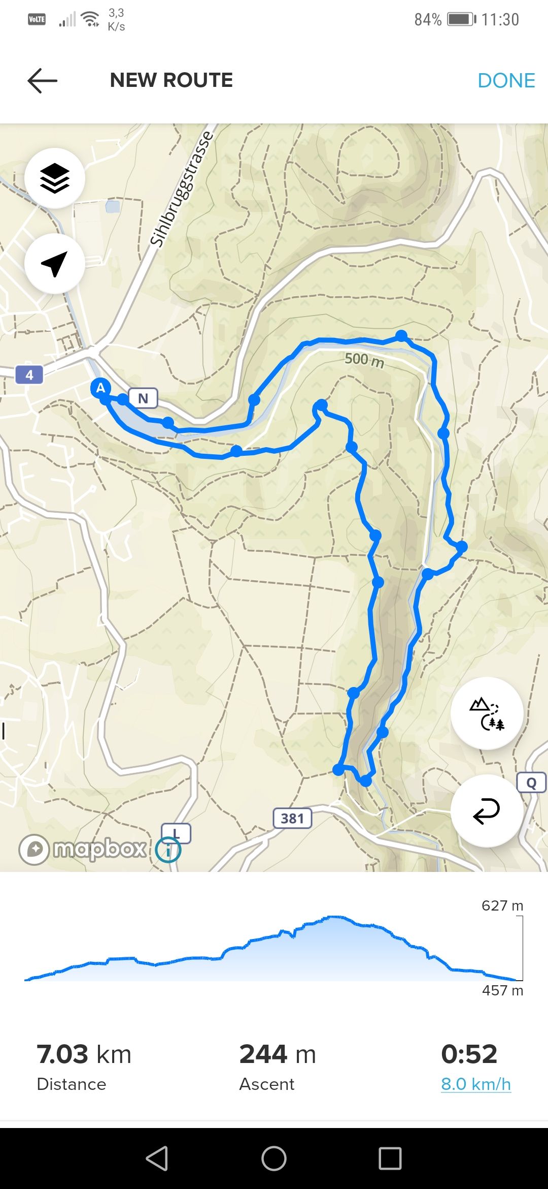
                              the following route was measured to 7.00km with my S9B and 181m ascent. I replicated the route planning just before… I ran exactly that route.

                              You are right for consecutive and long climbs. The watch has less or let’s say almost no issues with that… but the calculation for rolling hills is more demanding and if you search the forum, mr silentvoyager, who regrettably did a Suunto exit (I will not abbreviate that here…) had good inputs and wide discussions about that topic. @Dimitrios-Kanellopoulos is aware of that and hence Suunto, too 👍 🙂

                              Screenshot_20200306_113030_com.stt.android.suunto.jpg

                              living sideways

                              1 Reply Last reply Reply Quote 0
                              • mario_bM Offline
                                mario_b
                                last edited by

                                @TELE-HO i know what you mean, but i would not care to much about meters in 10 increments. i care more of the 100s of meters.
                                a good example of a detail where i have to say, the elevation map is good, the trail is good, and the calculation of suunto is good. but here you can see why such calc’s are happening:
                                Bild 06.03.20 um 11.56.jpeg
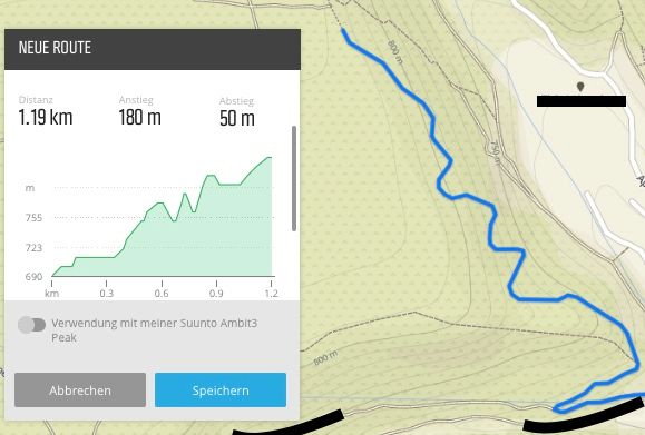
                                the trail is only ascending here. but the small turns return in a crossing of elevation lines. so in real the ascent is 120 up and no descent. such sings will always happen, on any rout planning platforms. 🙂 but i can’t say, the did a bad job. it’s just the fact, that the calculation is only as good as the maps.

                                1 Reply Last reply Reply Quote 3
                                • zvonejanZ Offline
                                  zvonejan Bronze Member @freeheeler
                                  last edited by zvonejan

                                  @TELE-HO

                                  I don’t trust the route planning tool in regards to total ascent. When I plan, I get predicted total ascent of around 125 to 130% of the actual total ascent.
                                  I once checked it with S9B and A3PS. Yes S9B is a bit short on ascents but way closer to A3PS than the planned route…
                                  despite that, I have in memory that Suunto is working on a fix

                                  This is not problem of Suunto :). Suunto does not have own database with altitude data. Look at the track created, it is very serrated or wavy which increase acsent a lot

                                  1 Reply Last reply Reply Quote 2
                                  • zvonejanZ Offline
                                    zvonejan Bronze Member
                                    last edited by zvonejan

                                    route created on movescount

                                    tol-mov.JPG

                                    actual route recorded with s9b

                                    tol-mov-real.JPG

                                    ups it is inverted 🙂 i created from end to start

                                    1 Reply Last reply Reply Quote 1
                                    • First post
                                      Last post

                                    Suunto Terms | Privacy Policy