Real world data
-
Real life data from french Alps

S9P on my wife’s arm vs SSU on my arm (OK, not perfect comparison, but it is real life, no ? )
? )- GPS used :
SSU = GPS only
S9P : GPS+GLONASS = default mode before i know how to change it - Best mode on both
- No manual altitude calibration, both were 10/20m correct at home
- environment : mountain nearby, beginning in not so open field, then heavy folliage downhill, then open field on the left but local Manhattan buildings on the right (understand big trees of the edge of the woods
 )
)
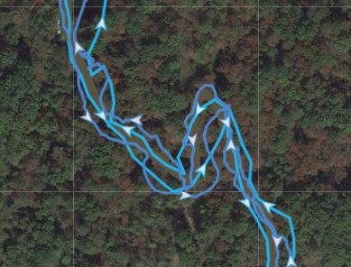
Here is are representative segments of this move :
Light blue = SSU
Dark blue = S9P
Woods portion
Manhattan towers and then more opened field
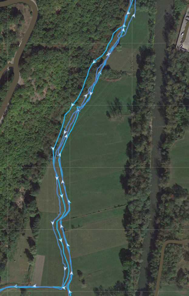
mixed feeling on GPS: not that bad, not that exceptionnal (maybe glonass is not good, or just the first run (watch announced that running and walking were calibrated, but i am more thinking about pace and so on).
very good feeling about battery (even if it is a very short run)

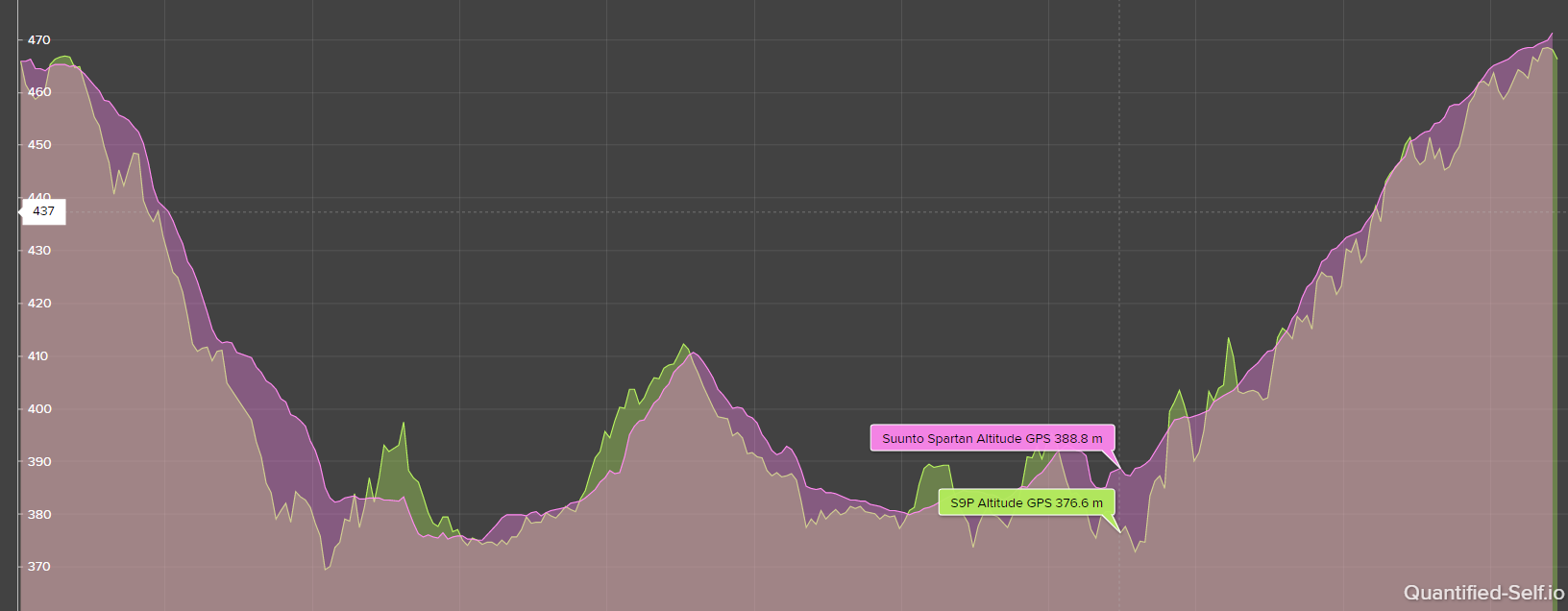
GPS altitude raw data : SSU has really smoother data (not to say it is good or not, just a fact, as it is not these values that are retained). Maybe little proof that GPS+Glonass or that very first run was not good for GNSS S9P.
twice more satellites fixed on S9P but SNR is on par with SSU.
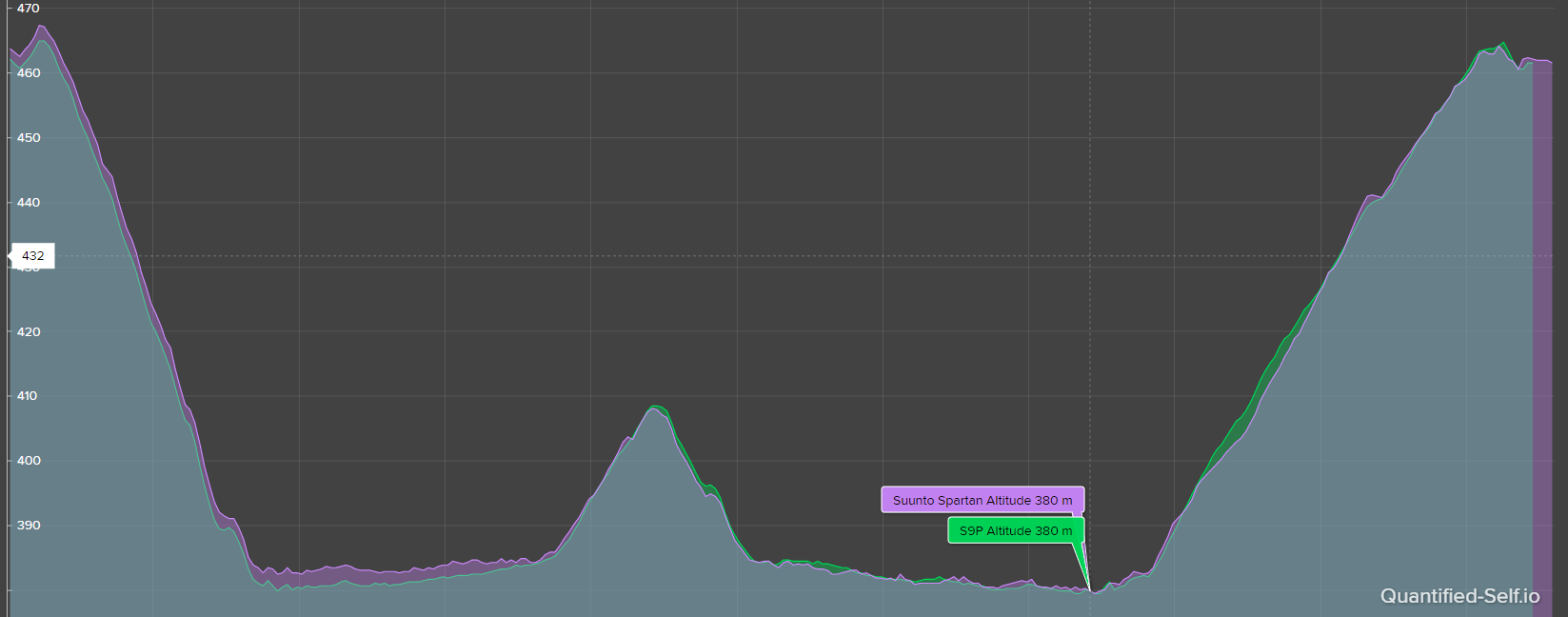
As expected, final altitude data are really good, fusedalti worked as expected.
I will see with the time how S9P is managing live altitude correction (because SSU works differently (correction at start only)
And special words for Quantified tool, still best at doing such comparisons

- GPS used :
-
@_marcus_ This was a flat trail next to the river. So, S9P 0ft ascent was probably a tad less than real, you can see some ups and downs there, but was probably more accurate than 24ft Fenix put me for.
On that flat run F6X managed to totally lose the story on the basic elevation profile – forget the absolute numbers or cumulative loss/gain. Notice the two of them start roughly equivalent and then about the middle F6X goes to pieces and never really recovers. Interestingly, that’s when I was heading back and F6X found itself next to the cliff wall.
Oh, and 24ft Fenix reported ended up being 16ft in Runalyze that auto-corrects elevation based on GPS data. TP, when I corrected it there, also arrived at 16ft gain. So, that’s 30% reduction right there from the watch reported numbers. Throw in a correct GPS path, and we’d probably have been down to 6-10ft.
I have runs with real hills coming up, will see the story there. But for now I can say Peak performs every bit as well as S9B, and its OHR is orders of magnitude better.
-
@nickk
here is a comparison (date is when I got them, Fenix 6x was bricked and I got the refurbished one) of S9B Charcoal Titanium (2021), Fenix 6X Sapphire (Refurbished Feb. 2021) and Vertix (August 2020) for a trailrun. All are good in case of elevation.
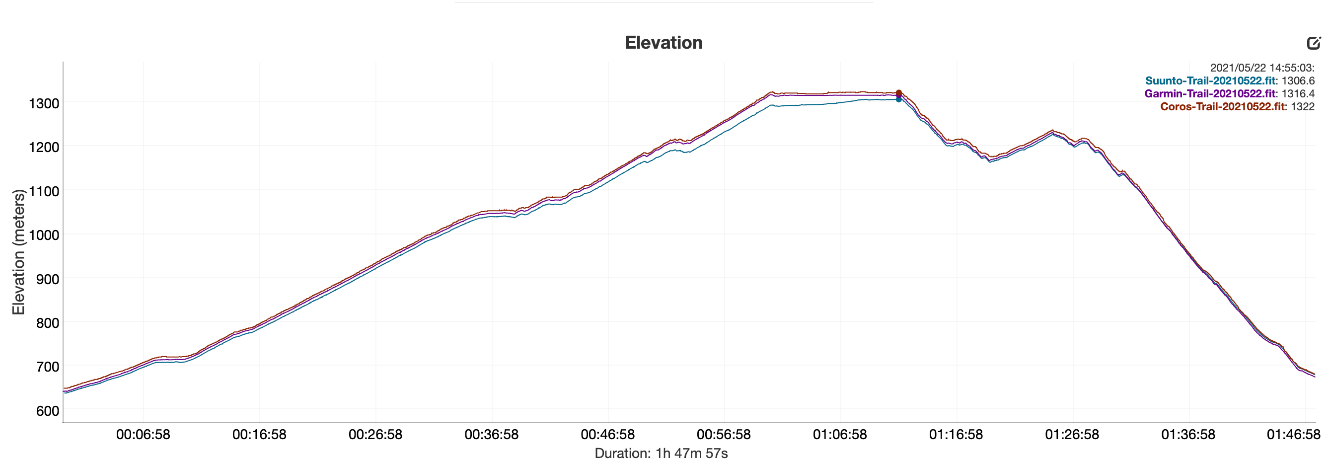
There are several “drops” in distance with the S9B that I can’t explain.
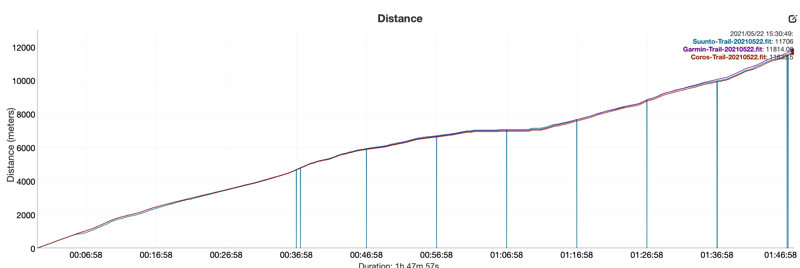
Differences in Distance and Ascent:

Power and HR is for all watches from Stryd and Polar belt and differs too. Maybe Bluetooth and ANT+ protocols make these differences.I don’t use oHR, too many hairs…
-
@_marcus_ are you using DC rainmaker ? If yes his software cannot handle missing values (ie no distance update but we’ll elevation update) and ads 0 instead. Old way of dealing with data ie when a bike sensor did not broadcast power it was assumed to be 0. But dcr maker tool assumes all data is power.
-
@dimitrios-kanellopoulos thank you for clarification. Yes, it is DC Rainmakers Analyzer.
-
@_marcus_ Even assuming F6X is correct in that case, and it’s a big if, the ascent difference between S9B and F6X is 14m, or about 3%. It seems most of it is due to a single portion of the route near the top where S9B pegged you lower for whatever reason.
Honestly, I’d take that over 30% I just showed for F6X in Runalyze above

-
@mff73 slightly offtopic but I can never find the battery burn rate in QS activities, does it require enabling something extra? I was wondering if it was device limited because I remember the Spartan Trainer is a bit dubious for battery counting from memory.
-
@the_77
Do you have Android phone?
If yes, after watch activity sync with SA, there is a specific file stored somewhere in your phone and this file need to be imported manually in QS (Dimitrios developped the import specially).
It will create a new acitivity entry in QS (duplicate with the one automatically synced from SA). Only this file contains battery info.More details here
https://forum.suunto.com/post/33052
Or here
https://forum.suunto.com/post/86681 -
@nickk I said that for trail running elevation for all watches is quite good. I wanted to underline my statement with the screenshots

There was just that huge difference in ski mountaineering. But we will see how S9P will be in the cold and bad weather…
-
@_marcus_ said in Real world data:
@nickk I said that for trail running elevation for all watches is quite good. I wanted to underline my statement with the screenshots

There was just that huge difference in ski mountaineering. But we will see how S9P will be in the cold and bad weather…
I do a lot of Ski Mo and do not see this issue comparing either my S9 Baro or Peak against my friends Garmin watches. We are always within reasonable error of each other.
-
S9P arrived yesterday, unfortunately too late for my morning and noon “utility” runs. So this morning it was, used the belt out of habit (no VO2max from this run btw), so cannot comment on OHR but the track (GPS only) was better than what the S9B had ever produced - and I tend to run this same route several times a week. It is an urban environment, so the track is not perfect but the Peak could even deal with my 180° turn (perfect on my way back, better than S9B but with some issues in the way out - but there is a wall on the lhs just before). Curiously, the default run mode with power (have a Stryd) is quite different in terms of fields and screens from the S9B - not an issue as can be customised but just interesting. Overall very happy but still many things to explore
 !
! -
@mff73 I do have one indeed - I’ll have a play tomorrow.
-
5k “walk run “ s9p in gps only
https://www.suunto.com/move/andrfaria640/60cc26410a970d0c596558feGarmin 245 (doesn’t have baro ) + decathlon hr strap
https://connect.garmin.com/modern/activity/6977857873Small 16k team bike ride:
S9p
https://www.suunto.com/move/andrfaria640/60cb342bf1f0e24ada24b377Edge 530 (decathlon hr strap)
https://connect.garmin.com/modern/activity/6973800924 -
@andré-faria Hi André, thanks for sharing you data
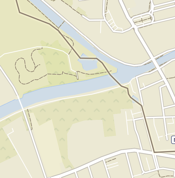
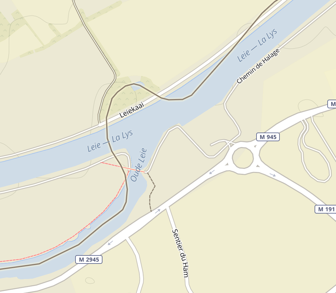
 … did I get I right, the gps data were not that nice, or? what kind of setting did you use at GPS settings? Many thanks, Martin
-
@andré-faria That looks good, thanks for sharing.
-
@andré-faria said in Real world data:
5k “walk run “ s9p in gps only
https://www.suunto.com/move/andrfaria640/60cc26410a970d0c596558feGarmin 245 (doesn’t have baro ) + decathlon hr strap
https://connect.garmin.com/modern/activity/6977857873Small 16k team bike ride:
S9p
https://www.suunto.com/move/andrfaria640/60cb342bf1f0e24ada24b377Edge 530 (decathlon hr strap)
https://connect.garmin.com/modern/activity/6973800924Same trace (±) on different times with different watches (some altitude may vary if I climbed some stairs on the way or notm but it should vary that much, although not everytime the case)
Ambit 3 peak sapphire
https://www.suunto.com/move/andrfaria640/5fc9dd2f586ad13e50eca662
Garmin FR45
https://connect.garmin.com/modern/activity/6315306290
Fenix 6s sapphire
-
@gosem said in Real world data:
@andré-faria Hi André, thanks for sharing you data
 … did I get I right, the gps data were not that nice, or? what kind of setting did you use at GPS settings? Many thanks, Martin

What activity is that?
I was seeking those parts and can’t find them.
I found the gps quite good, specially because this zones are tricky for gps.
Setting GPS+QZSS -
First mountain tour today with the S9P and the altitude measurement and the GPS make a very good impression.
-
I did my first ride with the S9P yesterday. Most of the data seems to be good, though the S9B OHR is way too high compared with my Wahoo Bolt + Polar OH1. It reads at least 10-15% high during a threshold effort:
S9B: https://www.suunto.com/nb-no/move/lakerveldt/60cb8f3fe9893c2c684ef50a
Bolt + OH1: https://www.strava.com/activities/5486185880
This was pre FW update to 2.16.26. I continue testing troughout the weekend where I have a swim, long run and long ride planned.
I love the form factor of the S9P compared with my SSU though!
-
Did a hike today to check out new trails and do a bit of recovery. Had a route set up and used snap-to-route feature. Here’s a comparison to F6X that was just tracking in the background, connected to HRM-TRI:
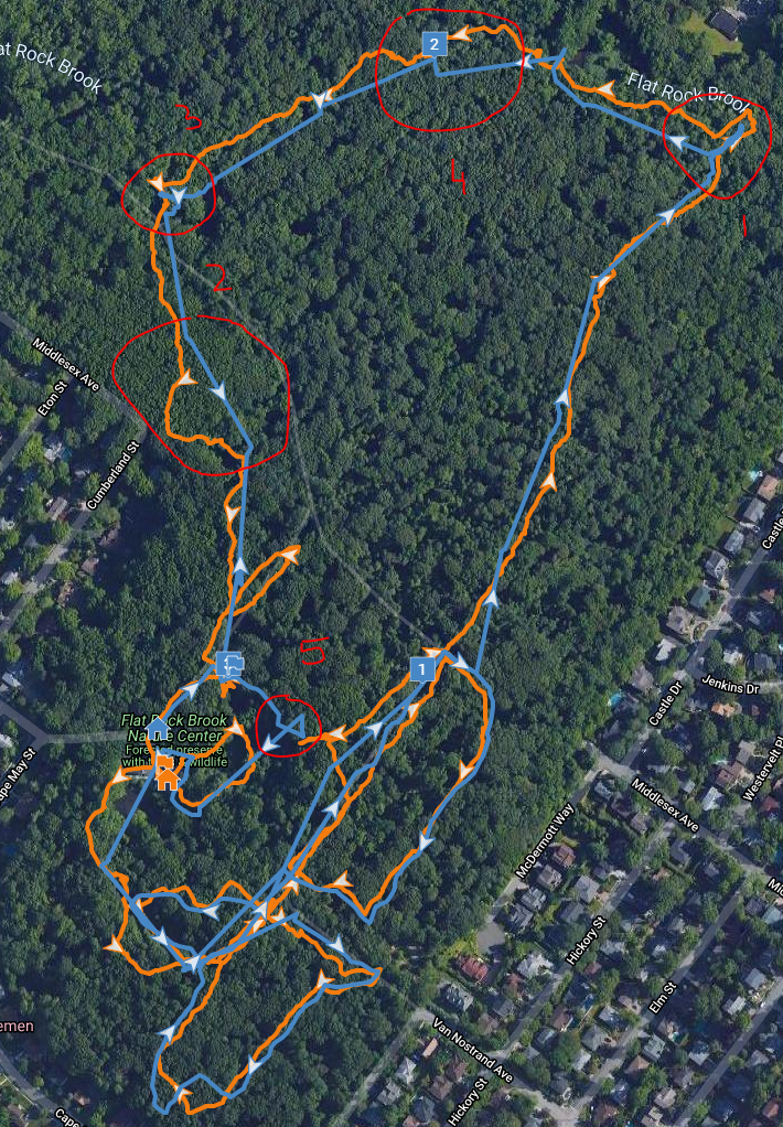
Some of the points:
- I think despite snapping, S9P is right here, I quickly went down the wrong path then came back. No way it was in the roundabout fashion of F6X.
- Here we see snap-to-route artifact cutting me straight even though trail was running around a bit. You can see plenty of those straight sections even though I was getting on and off the route to get the picture. Yes, snap was meant to do that, but looks funny on the trail
- Another case of wrong turn. S9P is probably closer to reality.
- Not sure what happened there other than snap-to-route artifact.
- Some UFO maneuvers by snap-to-route. Busted! US Navy, you found me!
All in all, given how close the network of intersecting trails was I think snap-to-route performed fairly well despite plenty of obstruction from rocks and trees. It did cut some of my wondering. Final distance is 2.57 in S9P, 2.60 in F6X.