Suunto app Forum Suunto Community Forum
    • Recent
    • Tags
    • Popular
    • Users
    • Groups
    • Register
    • Login

    Real world data

    Scheduled Pinned Locked Moved Suunto 9 Peak
    164 Posts 29 Posters 15.5k Views
    Loading More Posts
    • Oldest to Newest
    • Newest to Oldest
    • Most Votes
    Reply
    • Reply as topic
    Log in to reply
    This topic has been deleted. Only users with topic management privileges can see it.
    • isaziI Offline
      isazi Moderator @wakarimasen
      last edited by

      @wakarimasen quantified-self.io 🤟

      Watch: Suunto Vertical Ti

      Blog: isazi's home

      W 1 Reply Last reply Reply Quote 2
      • W Offline
        wakarimasen Silver Members @isazi
        last edited by

        @isazi I’m a user - just not sure about how to go about making the comparison 😉

        Suunto Race Titanium
        Suunto Ambit3 Peak
        Polar H10
        Polar OH1

        isaziI 1 Reply Last reply Reply Quote 0
        • isaziI Offline
          isazi Moderator @wakarimasen
          last edited by

          @wakarimasen record the activity with two or more watches, sync them to QS, then select and merge activities

          Watch: Suunto Vertical Ti

          Blog: isazi's home

          W 1 Reply Last reply Reply Quote 1
          • W Offline
            wakarimasen Silver Members @isazi
            last edited by

            @isazi Great stuff - thanks!

            Suunto Race Titanium
            Suunto Ambit3 Peak
            Polar H10
            Polar OH1

            1 Reply Last reply Reply Quote 1
            • ? Offline
              A Former User
              last edited by

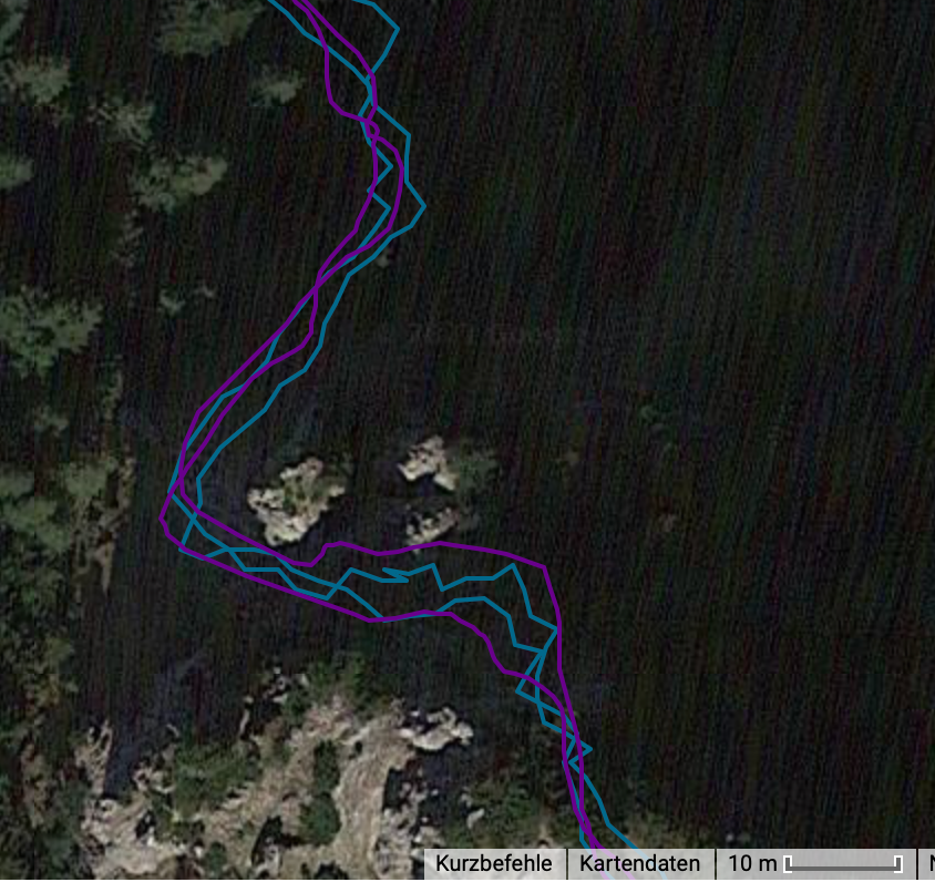
              just a short comparison an my run today

              S9P (violet) is also very good. the Vertix (blue) is a bit smoother and gets some curves a bit better, but this is only in detail.
              df8d2aba-4750-44b7-a041-514527c07f83-image.png

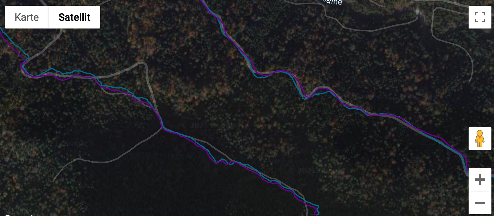
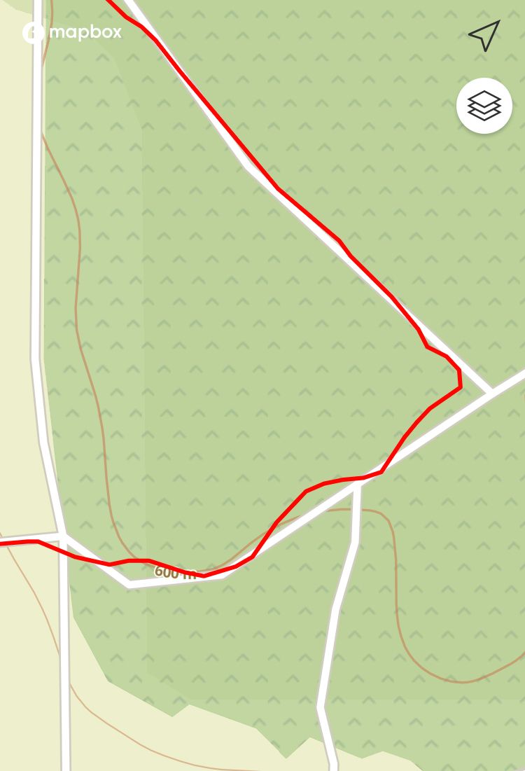
              Here is a tricky part because high rocks surround the steep path (UIAA 1). Coros smoothes it a bit more so it looks a bit better. Therefore the upper violet track is a bit off track but blue makes that “step backwards” below the upper right rock.
              6d5fcecd-ad67-480f-9634-898680ef9f09-image.png
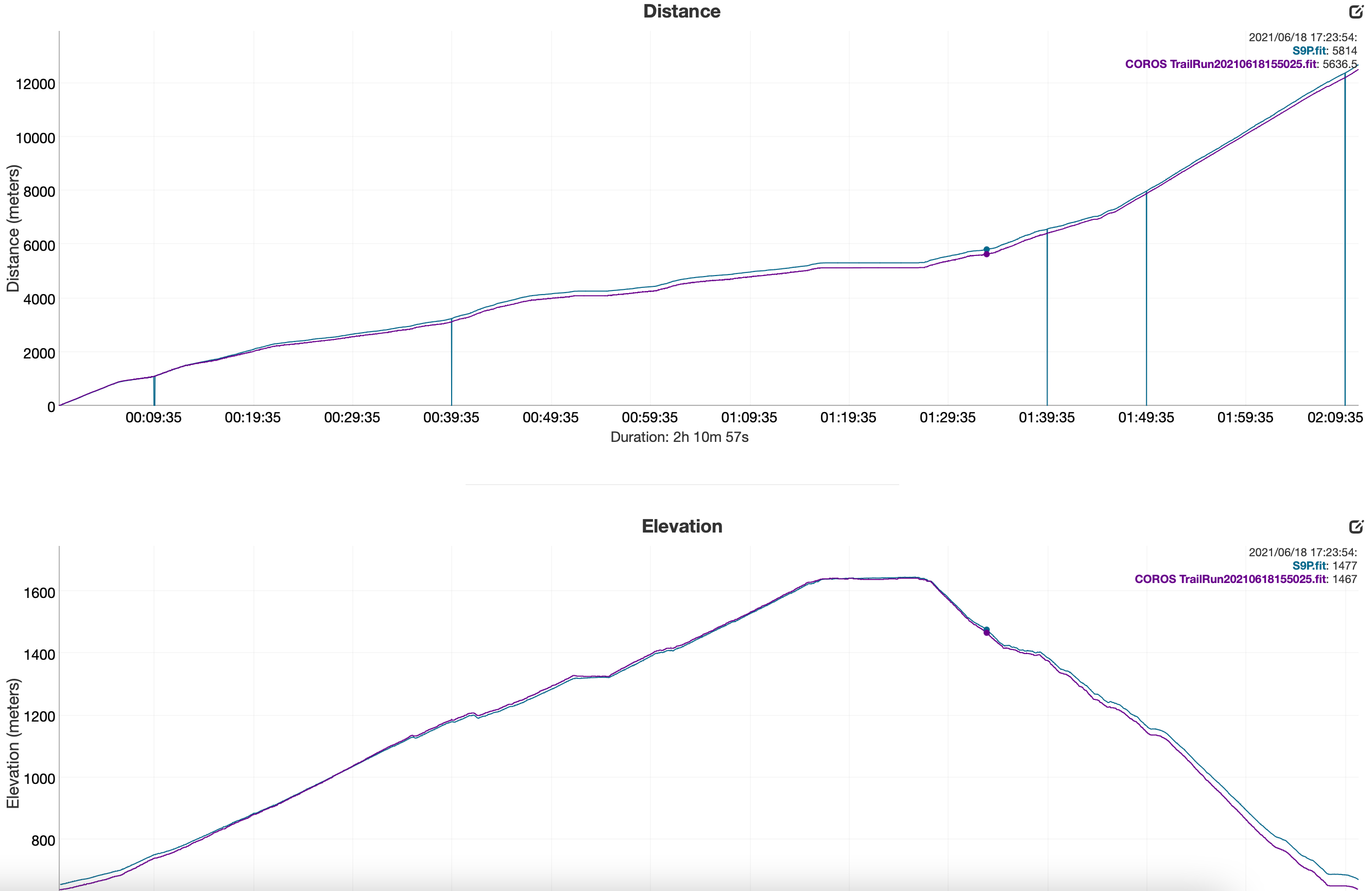
              I don’t think in this detail you cannot say that anyone is better or worse than the other. Both do a very good job.

              S9P is above. I would say that S9P got the elevation better today. Average over all my runs up to this summit is 997m.
              955fc4f0-63b6-440b-a3ab-fadaeca8c8f3-image.png

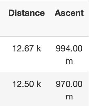
              But again the “zero-values/dropped values” on the S9P. Why is this?
              b0cacf09-ac18-45af-968f-ff843a70f194-image.png

              Battery drain:
              S9P 11%
              Vertix 6%

              I don’t test oHR as there is no watch that can measure it correctly on my wrist (only on a steady run with little HR-changes). But hiking, intervals, trailrunning especially with poles… no chance for me to get plausible oHR values.

              Good job Suunto

              1 Reply Last reply Reply Quote 0
              • fazelF Offline
                fazel Bronze Member @Theo Lakerveld
                last edited by

                @theo-lakerveld woah - that’s a HTFU effort. How often you doing 60 min straight at threshold?

                Theo LakerveldT 1 Reply Last reply Reply Quote 0
                • andrejsgA Offline
                  andrejsg
                  last edited by

                  Used mine for a couple of days and so far it’s performed impressively better than my 9 baro. Wrist hr is finally accurate (first suunto for me to do this) and ths GPS is very impressive. A worthy successor. I’ll post more once I get more runs in.

                  1 Reply Last reply Reply Quote 1
                  • v.sacreV Offline
                    v.sacre Silver Members
                    last edited by v.sacre

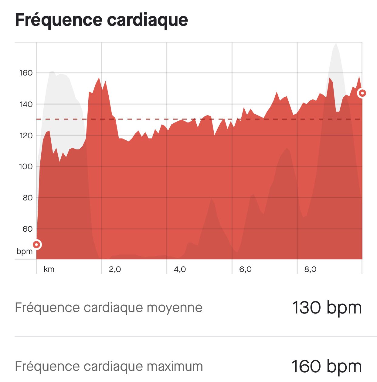
                    Pretty impressed also with the new OHR of the Peak !
                    Here under compared with a Wahoo HR strap during a gravel ride. Still some small bug but for the majority of the ride that was spot on !

                    d325a504-319f-420a-9214-1babb8347ba5-image.png

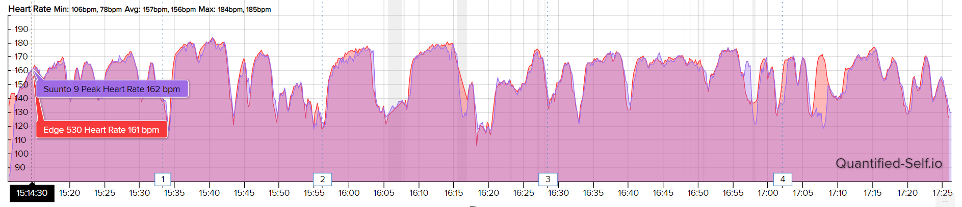
                    GPS track is also very consistent. Only 0.3km difference for a 50k ride.

                    A3S | S9B | S9P | S9PP | Suunto Vertical Ti
                    Suunto Wing

                    C 1 Reply Last reply Reply Quote 2
                    • C Offline
                      chrisc92 Bronze Member @v.sacre
                      last edited by chrisc92

                      @v-sacre
                      I add also I first good impression for the OHR , I wanted to record the activity with my polar H10 HRM unpaired but forgot to activate recording on polar App.
                      82267A24-15F9-4542-A7BD-D78AE3763042.jpeg
                      Tomorrow I will record with my trusted HRM to study more thoroughly this small peak 🙂

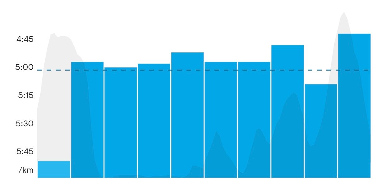
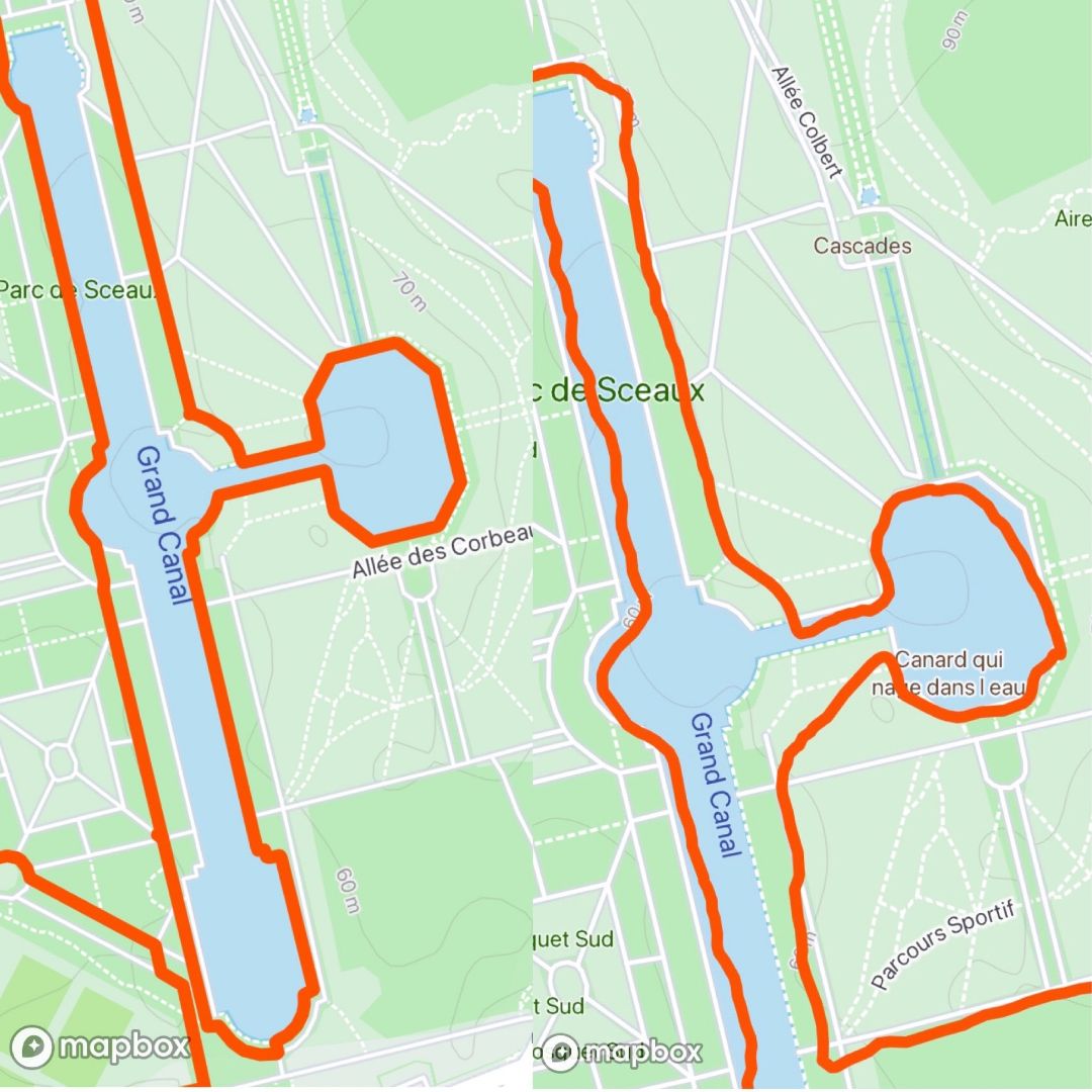
                      I also tried snap to route feature although this is not specific to S9P but to firmware. It plots very satisfying tracks 😊
                      6EAB50DA-6D5F-4AF9-B72D-A0BC0BB88725.jpeg
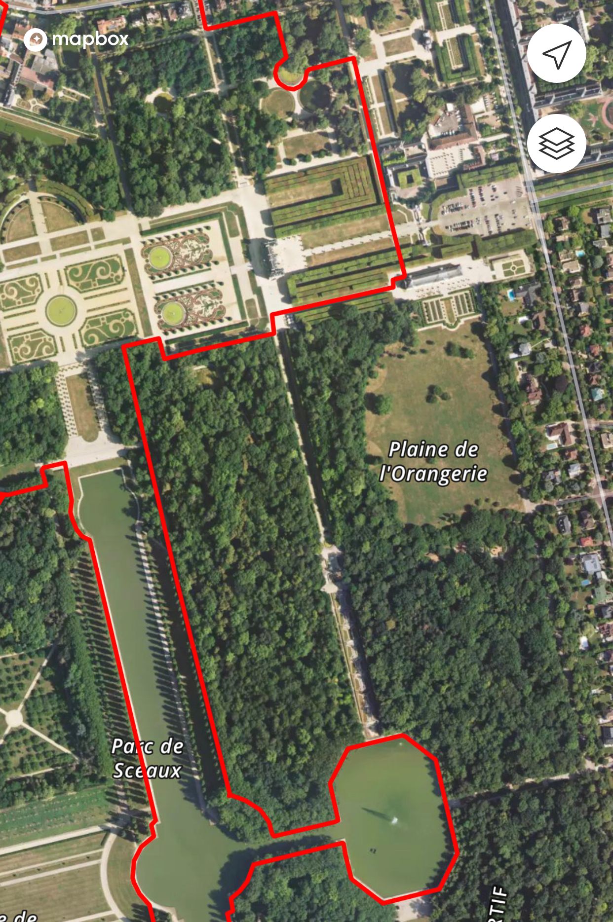
                      This is a very good feature for regular pacing , now I can really trust the displayed pace during a workout
                      C455B6C3-EED2-456B-8181-4D11411C8223.jpeg

                      Just at the end you have to stop the activity at the end of your route . If not, the gps recording continues but not distance which remains blocked at the route length !!
                      A8350729-80A6-4D1E-A177-D4AC0ABC525B.jpeg

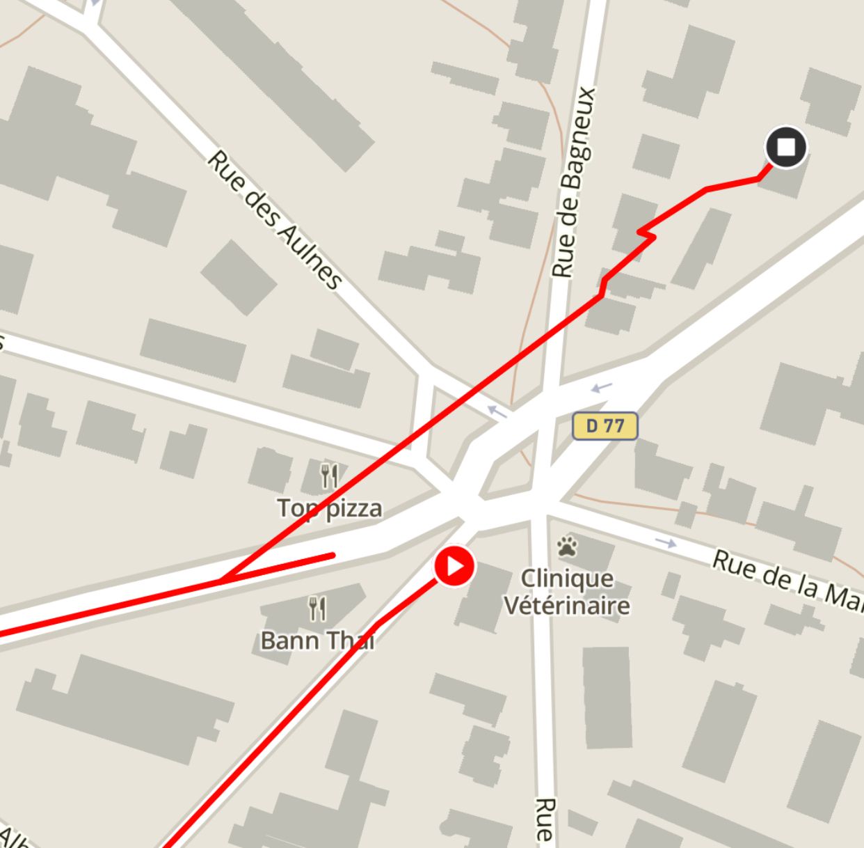
                      Also if you have a foot pod the distance displayed on the watch may be different at the end as it is specific to calibration.

                      ink357I 1 Reply Last reply Reply Quote 0
                      • ink357I Offline
                        ink357 @chrisc92
                        last edited by

                        @chrisc92 I don’t understand the usefulness of this function. I think we want to see the real route we’ve done, not the THEORICAL one

                        Dimitrios KanellopoulosD C 2 Replies Last reply Reply Quote 1
                        • G Offline
                          Gosem Bronze Member @Guest
                          last edited by

                          @andré-faria Hey André, I guess it was my fault, I mixed something up, that’s not the GPS Data, the brown line was something from the map. But it looked like the data … sorry for that

                          1 Reply Last reply Reply Quote 1
                          • Dimitrios KanellopoulosD Offline
                            Dimitrios Kanellopoulos Community Manager @ink357
                            last edited by

                            @ink357 when the real route is prone to be bad , for example new York running cannyons etc or even a race you can just get the theoritical route , and not worry why your watch gps went south adding 1-5km more or less.

                            Since you want to see the real route , just don’t use this feature 😁

                            Community Manager / Admin @Suunto
                            Creator of Quantified-Self.io
                            youtube.com/c/dimitrioskanellopoulos
                            https://instagram.com/dimitrioskanellopoulos
                            https://www.strava.com/athletes/7586105

                            C 1 Reply Last reply Reply Quote 4
                            • C Offline
                              chrisc92 Bronze Member @ink357
                              last edited by chrisc92

                              @ink357 that is exactly what it does , when I run on a route the GPS doesn’t record the exact route because of trees , direction changes, wheater. So the pace is not often true .
                              E402CC6F-E9E0-4A25-A9F3-8F1C3113060D.jpeg
                              The route is not he theoretical path it is where I ran exactly. GPS make people run through building or water this is not true

                              ink357I freeheelerF 2 Replies Last reply Reply Quote 2
                              • C Offline
                                chrisc92 Bronze Member @Dimitrios Kanellopoulos
                                last edited by chrisc92

                                @dimitrios-kanellopoulos said in [Real world data](

                                Since you want to see the real route , just don’t use this feature 😁

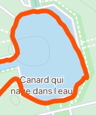
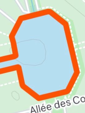
                                Ten year running around this small duck pond , people thought I was cuting the edges 😃
                                So what is the real route ?
                                0452B5A3-4839-4C6E-B04A-2410D28EA21E.jpeg AEC8CE90-E3DA-4EEF-8AC4-962507BA6350.jpeg

                                1 Reply Last reply Reply Quote 1
                                • ink357I Offline
                                  ink357 @chrisc92
                                  last edited by ink357

                                  @Dimitrios-Kanellopoulos @chrisc92 said in Real world data:

                                  The route is not he theoretical path it is where I ran exactly. GPS make people run through building or water this is not true

                                  I run a lot in trail and I often have to miss the “real” path or cut through wood.
                                  I worry about the fact that the software “forces” my route on the theoretical route

                                  Dimitrios KanellopoulosD ? ChrisAC 3 Replies Last reply Reply Quote 1
                                  • Dimitrios KanellopoulosD Offline
                                    Dimitrios Kanellopoulos Community Manager @ink357
                                    last edited by

                                    @ink357 then don’t use it 😀 ¯_(ツ)_/¯

                                    Community Manager / Admin @Suunto
                                    Creator of Quantified-Self.io
                                    youtube.com/c/dimitrioskanellopoulos
                                    https://instagram.com/dimitrioskanellopoulos
                                    https://www.strava.com/athletes/7586105

                                    1 Reply Last reply Reply Quote 4
                                    • ? Offline
                                      A Former User @ink357
                                      last edited by

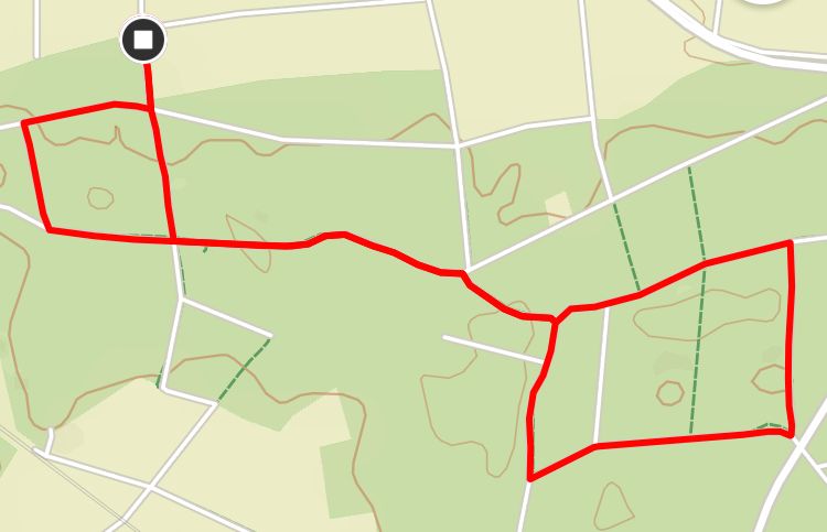
                                      @ink357 I did a trail run test yesterday, a single 5K-ish loop through the forest. I did follow the planned route. My S9P showed 3.07 mile (correct) and my F6X showed 2.81 miles, off by roughly 9%. Some of it might have been due to footpod, some due to auto pause when I was stopping to take pictures. Though needless to say, S9P was in exact same situation.

                                      Now imagine same error for a marathon distance!

                                      While snap-to-route has its limitations (I showed some above), I think it’s working pretty darn well when you stay close to intended route and trail info is reasonably accurate in the maps. Yes, this won’t help everyone in every situation, and yes, there might be some weird glitches every now and then, but given a choice I’d take that over 9% error.

                                      1 Reply Last reply Reply Quote 3
                                      • ChrisAC Offline
                                        ChrisA Platinum Member @ink357
                                        last edited by

                                        @ink357 you can always run like before - no worry. But I understand that it’s useless when there is no real path to follow. I like it because you now really get the km an the pace you planned even when gps isn’t that good e.g in the woods. Run the other day and the track is just awesome exactly there where I actually ran 😎:

                                        D3D5B2AC-EF48-4DBC-8A71-727DB08C5A6A.jpeg

                                        Instead of (though it’s also ok for me) me looking like running drunk through the Forrest:

                                        F0CDB2BA-54EE-475F-A6E3-7037C8B1F0DC.jpeg

                                        1 Reply Last reply Reply Quote 1
                                        • P Offline
                                          pschenn
                                          last edited by pschenn

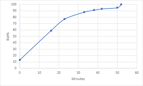
                                          Today I charged the S9P for the first time from 13% to 100% and it took only 52 minutes!

                                          Up to 80% took only 25 minutes. After 90% things slowed down a little bit. In the last 2 minutes, it snapped suddenly from 95 to 100%, probably due to a recalibration of the battery since it was the first time…

                                          e07a4704-098a-4c0f-9d41-bf8dec195e8f-image.png

                                          b2c1e8be-5acd-47d9-9293-a694c5d4bfe4-image.png

                                          Mff73M 1 Reply Last reply Reply Quote 1
                                          • freeheelerF Offline
                                            freeheeler @chrisc92
                                            last edited by freeheeler

                                            @chrisc92 said in Real world data:

                                            sketch-1624121596081.png

                                            this pic reminds me of ISO GPS class and examples 🤓

                                            living sideways

                                            1 Reply Last reply Reply Quote 1
                                            • First post
                                              Last post

                                            Suunto Terms | Privacy Policy