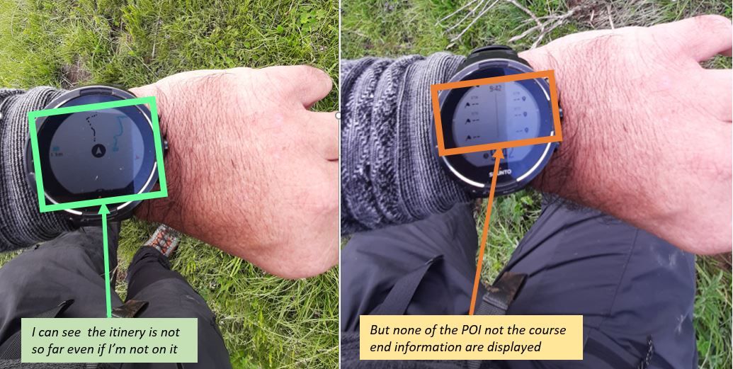
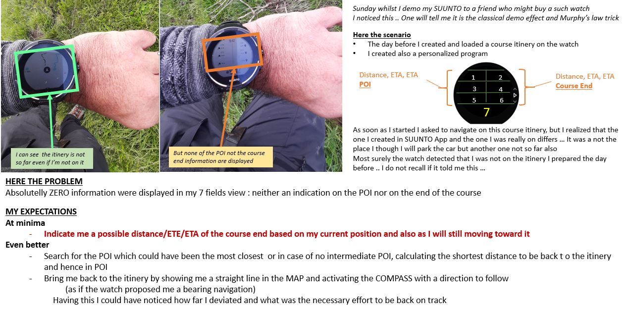
Is it a navigation BUG .. Distance/ETE/ETA remained empty despite I was not far from the itinery
-
@дима-мельниченко
hello
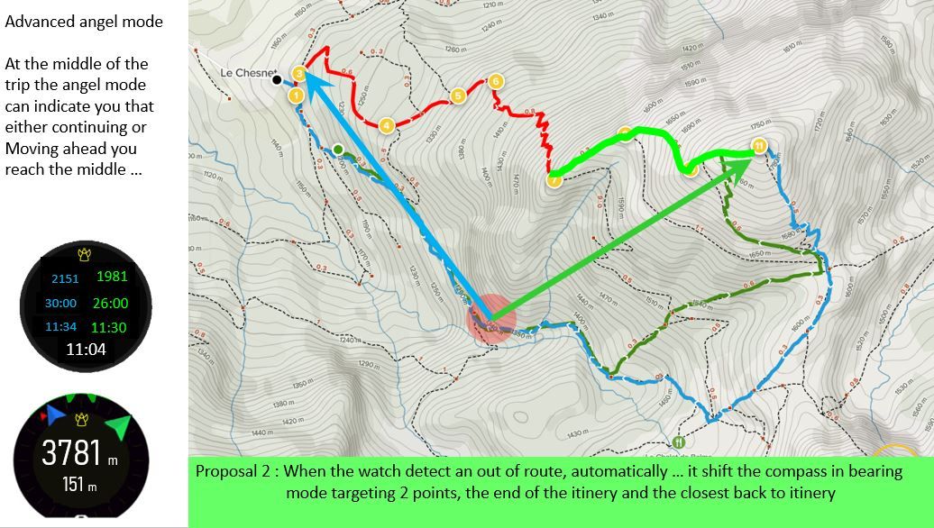
I thaught more to your idea and I should confess that your proposal is even better that mine, much mor eeasy to put in place, not need to perform comple computations to search for any closest point between where I’m and the planned route.Simply : BEARING mode indicating 2 points : the real point from where I started my journey (back to safety) and the targeted point of my itinery (soon to safety)
Doing so you can decide also continuously if you still continue or you prefer to stop and go back to where you came from … you can see at which moment potentially you reach the theoritical point of no return (especially for example if there are some consideration with water)
Your proposal is by far better than mine.
Here illustrated :
At the begining, having the navigation to shifted toward BEGIN and END will let you know how to reach back the planned road
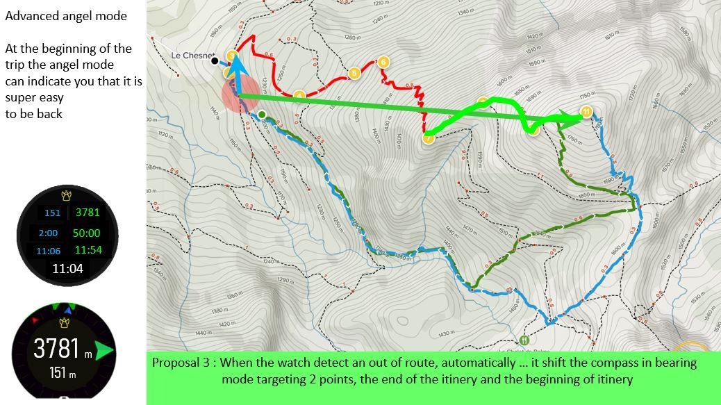
At a certain time you will see that you may reach a point of no return …
-
Yes this is exactly what I said with my poor english … talking about the “petit poucet” which is the french translation of tje find back.
Apologize my english is limited and sometimes I do not know the english term, my watch being in french mode
You saif exactly in 9 words what took me a chapter

Stil, the idea of @дима-мельниченко is a very good one.
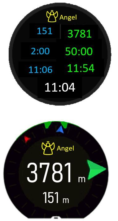
Although you have this famous find back option, in case the watch observe you are out of route, switching to a “Angel mode” it will let you now how far you are from the beginning (theoritical or real … to be discussed, may be theoritical as you always will have the find back option to reach the real one) and the ending of yoru journey
-
@mister-pyc I only think this shouldn’t be an automatic switch but rather an automatic suggestion. Otherwise it can be annoying to see bearing navigation instead of planned route in case one wandered off just a few hundred metres on purpose.
-
@дима-мельниченко not just annoying, even dangerous. You are walking on a trail, you miss one turn, your watch instead of telling you (as it correctly does now) “off route” starts navigating you somewhere that may be unreachable or dangerous, even giving you ETE!
-
Humm humm …
Thinking to recover through the phone is banned approach.
phone should be preserve for urgency, moreover nothing says that you can use it to create a new road … when you are around 4000 m … your phone has no more any 5G, 4G … 3G …May be a suggestion here.
In the navigation option, it could be nice to propose a new option to navigate to the START or END of an course. I understand as per yoru comments that they are not stored per say as POI but still they are stored in the watch, so could be interresting to offer a navigation to them;
In such case, no need to double your itinery by these 2 POI, which is what I did and allowed me to see that the navigation to the summit was giving me back distance, ETE, ETA information and also compass navigation
-
@isazi this may be omitted by imposing a constraint. Let’s say a suggestion similar to battery mode switching pops up iff more than 1 km of route or longer than 30min off route. These are more or less random numbers and exact ones need to be determined upon testing.
-
Humm humm
I was thinking to this … but I trend to disagree.
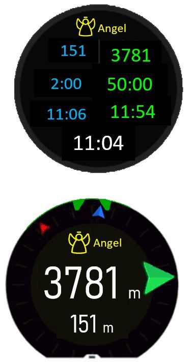
It is not different that having you create a wrong route which will push you to these embush.Moreover if clearly on the watch there is an angel which appears
Then SUUNTO cannot be taken for any responsibility here.
It was clearly an indication to help you, not a compulsary direction to follow.It is the same when you drive your car, you can go to 250km/h but it is 1) forbidden 2) dangerous, still I do not know a single beautiful luxuray car where you cannot either accelerate like a hell"s angel or drive far above the limits …
-
@дима-мельниченко the battery is pretty easy (one parameter) and not related to safety much (unless you are betting your life on your watch, navigating dangerous terrain with no visibility and relying only on your watch to survive).
-
@mister-pyc said in Is it a navigation BUG .. Distance/ETE/ETA remained empty despite I was not far from the itinery:
Moreover if clearly on the watch there is an angel which appears
Then SUUNTO cannot be taken for any responsibility here.
It was clearly an indication to help you, not a compulsary direction to follow.You are either the greatest lawyer or comedian ever.
-
@isazi
@Dimitrios KanellopoulosIs there a way ro rename this post into :
ANGEL MODE Proposal when your wath detect you are out of the route
.
it is definitively not a bug , now I catch the way the watch behave
It’s more a possible missing feature.Sunday I was thinking it was a bug in my watch because I was surprise that the watch did not compute th einformation toward the ending of the route despite I was no more on it … for me it was just abecoming a computation between 2 gps point
Still this disccussion is super interresting and should be renamed in somethign positive
-
@mister-pyc said in Is it a navigation BUG .. Distance/ETE/ETA remained empty despite I was not far from the itinery:
@isazi
@Dimitrios KanellopoulosIs there a way ro rename this post into :
ANGEL MODE Proposal when your wath detect you are out of the route
I cannot rename posts, you as the original author may, not sure. Although it may not be possible at all.
-
I was looking for this but did not find the option … of course you start to know me and that I’m often blind

I was thinking that you as moderator might have this super power
Let me stil try to search for it
Thanks in any case
These discussions are super interresting as challenging us and get fun to think that there could be some features … -
@mister-pyc often forum/discussion systems do not have this function to avoid the situation in which you get lots of upvotes for a topic, then change the name to achieve a different goal. So it may be the case for this forum too.
-
very logical indeed
Unfortunate as my title is not reflecting what I think now and would like to suggest
 -
As I said before - automation is good but only if it’s really well designed and here it’s very, very risky as @isazi pointed out.
I think that if you’re preparing for mountaineering having option A/B and C is crucial for survival and relying only on electronics, and especially on automated electronics sounds dangerous to me (but hey, I’m no.1 Deliberative in StrenghtsFinder, so I find dangers everywhere).
I also think that design goes beyond what we see on screen. It needs to adapt to market needs and as we sadly know - people don’t read manuals and even as simple as S line is right now - there are lots of confusing things that either manual doesn’t cover well or most people won’t care anyway. Also - we’re talking about multisports watch, not a specialized tool just for one or two activities (as your ideas @Mister-PYC might be very well relevant for mountaineering).
So - we have different battery modes (with a slightly malfunctioning ETA mode forcing 1s that I hope will be dealt with) and different navigation options - with POIs, routes and breadcrumbs all of which can be switched easily during the activity when needed - which I think is crucial as only the user knows when it’s best to use what.
BTW. You can have like 255 POIs in watch I think? And their icons will be displayed in navigation screen (although without names) when in breadcrumb navigation mode - regardless if routes are enabled or not. This is awesome and if in future it’s possible for the names to be displayed (even short - like first 8 letters) it would be an amazing tool for navigation even without maps.
-
@mister-pyc BTW - since you’ve mentioned that your English is limited:
Check out DeepL - https://www.deepl.com/pl/translator - since you’re writing really long posts, perhaps this AI-powered translator will help you in writing fast drafts in French.
It’s one of the best online translation tools available, I use it for translating blog posts from Polish to English as it saves tons of time.
-
I will say, you are right on the fact that watch cannot be specialized for a single given activity
but … I hope you will agree with me that the watch becoming silent just because you are at 200 m far from your planned road in the middle of a big mountain place is a matter of sadness … especially when this watch was offering you the capacity to compute distance, ETE, ETA computation toward POI and itinery ending, bearing navigation, altimeter, etc etcFor me having no more any information until and unless I reach by myself back to the road is still strange.
Imagine that WAZE did this to you … as soon as you see a beautiful restaurant jsut at 200 m from from the highway and you decide to brign your wife here for a good dinner, WAZE will have told you “Sorry man, now go by yourself to your destination, and only when you are on it I will tell you how to continue”

Joking of course, a such watch is not WAZE and it’s also good like that as it allow you to activate yoru brain and think which is the most important in mountain.
-
SUPER MERCI !!!
I will go for it immediatelly -
@mister-pyc honestly, it doesn’t bother me at all. You’re comparing apples to oranges. As I mentioned in some posts above - S5/9 is not an Android-powered S7 - which has maps and has a way better idea about your surroundings (like Waze does).
How can you compare road navigation that applies different route when you change directions (because it has maps and all the data it needs) with an outdoor navigation with no maps and weather data available?

I think that, perhaps, some of the ideas that you’re proposing - that are related to mountaineering and trekking - could be implemented but they would have to be somehow separated from the defaults. Profiles maybe? Seeing how Suunto tends to built its products - I doubt it.
But hey - there’s Suunto+ - so maybe, maybe, your ideas could be refined and implemented as mountaineering aids S+ screen? I think it would make more sense (in certain applications) than “Safe”. And it seems that S+ is just a right place for it to be. But on the other hand - it’s just one screen (but with plenty of automation in the background available and nobody would be forced to use it by default).
-
@łukasz-szmigiel said in Is it a navigation BUG .. Distance/ETE/ETA remained empty despite I was not far from the itinery:
nd we
Humm I do not catch where the apple and orange are

There is no need of any map when you have already loaded a GPX into your APP and transfert it into your suunto watch and you follow it.
if you look to my proposal which was made even better by @дима-мельниченкоHis suggestion based on my initial remark is really excellent and simple.
when the watch detect you are out of route, then why not to switch to this super good bearing mode where the point to reach could be eitehr the begining of the itinery or its end … straigh direct like you are doing if you activate the bearing mode.**Why I do not like the idea of having this addign this as a SUUNTO plus screen ??? **
because you can have only one single SUUNTO screen during an exercise and moreover you should decide of it when you start and you cannot change anymore.@дима-мельниченко proposal better than my initial one : ANGEL MODE
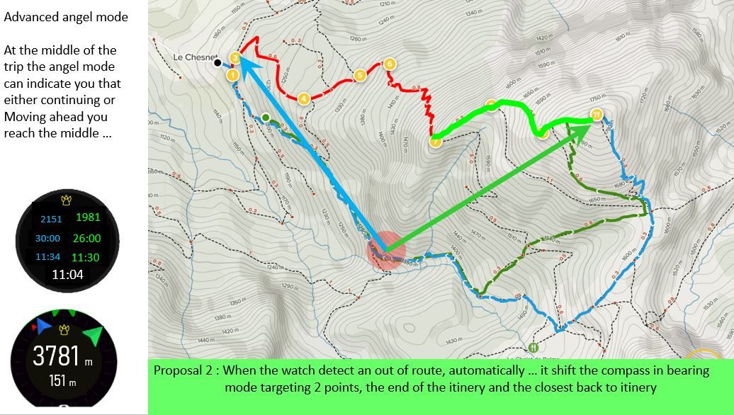
You are no more on yoru planned route, do not worry, an angel is coming to give you some help and telling you how far you are both from your start and end points of your loaded course
