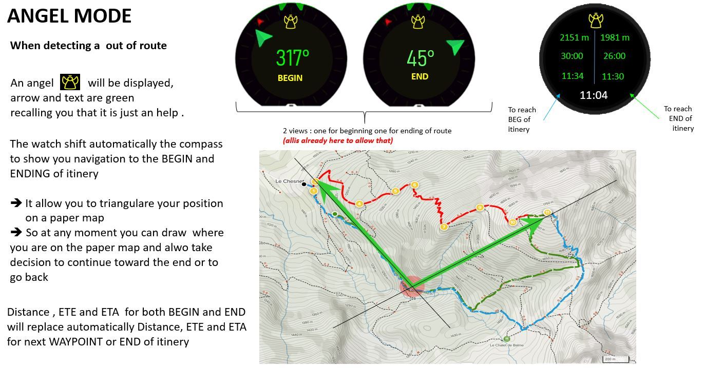
ANGEL MODE... When your watch detect you are lost and are out of route
-
@mister-pyc have you tried the safe Suunto plus ? It’s also a little interesting.
This way you always have back to start and you can load a route and do normal navigation
Community Manager / Admin @Suunto
Creator of quantified-self.io a portal that allows you to analyze your data from various providers, upload fit activity files to Suunto app, gpx routes and more… -
@t1sugar
hello t1sugar
This is precisely why I suggested the notion of ANGEL MODE with also an ANGEL icon to recall that it is JUST and really JUST indications that may provide you some help to “recover” from a situation but not in any case firm direction to go straight.
Concerning your proposal to indicate the closest point instead of the beginning of the route in ANGEL MODE … I was originally thinking like you but I realized it is a a “false good” idea for multiples reasons
- exactly as you say here it may give you an indication that you should go straight to go back to your route whereas, also as you say there might be some dangers (cliff, crevasse, a giant snake – joking –
- it requires the watch to perform a geometrical computation which is not such simple and energy consuming … for a result which can be challenged.
- it does not give you indications on your beginning point so you do know when you are half the way (for sure straitgh) and could not revisit your decision to pursue or to come back.
All is possible in IT
Driven by you fear you stay on the ground, driven by your dreams you fly -
@dimitrios-kanellopoulos said in ANGEL MODE... When your watch detect you are lost and are out of route:
start and you ca
Hello Dimitrios
well …
I tried Suunto plus but more for the WEATHER option which I like a lot as it gives you the feeling that you have a weather forecast help at your hand. … currently as there is a sole choice to do at beginning it will be this one I will put.I also tried the SAFE option, but frankly speaking it was not what I was thinking it should be … if you see my other posts I’m a little bit old (52) and with near view which decline … having the GPS coordinates written very small does not help me so much, and it has not added a compass with the azimut direction back to the starting point …
Having said that I might not have tested it enough and during my next trip I will test it again and let you know.
Something that the SUUNTO developpers should keep in mind : the watch is sometimes difficult to read due to the current luminosity, so any information which is written super small or too many super small info …or also some ligth color on light background are a pain and even worth not readable … this is why I prefer may be more screens that we can navigate but that contains bigger information inside …
… if you have time => see my posts on this subject :https://forum.suunto.com/topic/6728/watch-face-improvement-synthesis-pyc?_=1626365732652
it is the synthesis of all what I observed that could ease the reading … may be the UX team will considere it also
PS : I have a big powerpoint in which I put all my ideas if the SUUNTO team want it, it is at your disposal … for free
")
. -
@mister-pyc it does have (or should have
 ) a couple of those things. For sure the compass and incline difference.
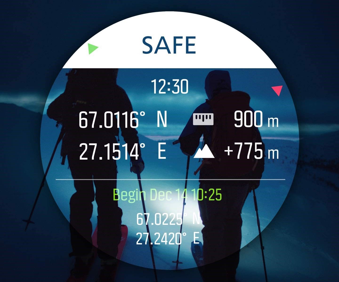
Community Manager / Admin @Suunto
Creator of quantified-self.io a portal that allows you to analyze your data from various providers, upload fit activity files to Suunto app, gpx routes and more… -
@mister-pyc thank you for your reply, without getting into specifics and extending any discussion as everyone has an idea of what they would like and use.
For me in reality its a moot point, I personally would never use my watch to gain a precise bearing as watch based electronic compasses are rarely accurate (in my limited experience), if I needed a bearing I would use an analogue compass that I generally know and trust. (either wgs84 or osgb position) would be good enough to establish where I am, even without this info I would use a analogue compass to establish a precise’ish bearing . what is provided in the Suunto Plus “Safe” option is good enough to establish where I am,
having the safe option as a screen we can use in a standard sport setup would be more ideal again for
me personally.the example of usage on a boat would never work, again my work takes me on boats and getting any compass set up correctly on a boat is an art, to adjust for Compass Deviation, Declination and Variation. placement is all important due to all the electronic radiation, boat materials present on a boat. costs alot of money setting up accurate compasses on any boat and a declination chart is produced based upon the direction your facing when taking bearings. etc.
p.s. these are not criticisms just my personal usage, I do like your ideas as they at the very least get you thinking about them and its how stuff is improved upon (no one individual has all the answers)
-
Hello dimitrios
Whaoouu !!!
It does not appears like this on my suunto 9 baro !!!
I will immediately test it.So you are not so far from what I was imaginating as an ANGEL mode !!
What are the difference between the ANGEL mode and the S+ SAFE mode and can this be integrated by the SUUNTO team ?
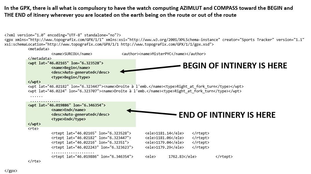
More I think to this more I think that having the Azimut and the distance to the 2 WAYPOINTS that are the BEGININING and the ENDING of the route is the MUST HAVE ?
Why ?
Because these are the sole easy points that are at the same time loaded in the watch and easy to get (in the GPX they are typed begin and end) and also that can be placed on a paper map.
So …
you can triangultate any position with them and clearly put in the paper map where more or less precisely you are located, this in the fog, white day or by night.
Are you far from this ?
No
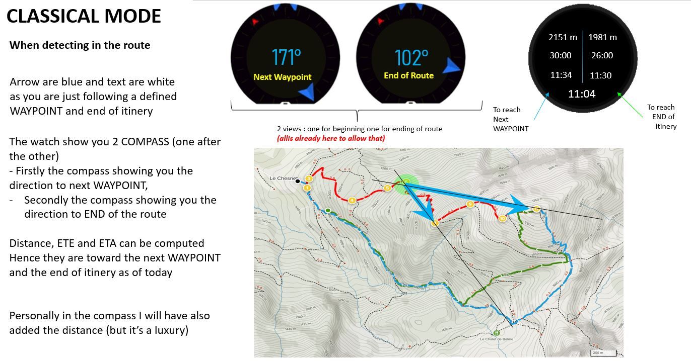
you just need to have 2 COMPASS that are displayed by clicking on the central button, the first one showing you the Azimut and distance of BEGINNING point, thenthe second oen the Azimute and distance of the ENDING point of your route.
Another approach which I was thinking orginaly was to combine on this SAFE screen 3 arrows : the NORTH, plus the second one pointing the BEGGINING point, the third one the ENDING point,. Honestly if I was the guy to choose I will have preferred this but it force the development team to change the compass behavior by adding some more computation and a display of a second arrow …
On suggestion also : if when you just press the screen the SAFE mode could display the distances and azimut versus this 2 points then you have it
See my proposal below,
All available on a single compass with with 3 arrows, the azimut, the distance if I press the screen and the distance, ETE, ETA revisited with same color convention as the arrow when ANGEL mode get activated … also as there are very few textual information displayed at a time, you can use big fonts, so a very easy lisibility
.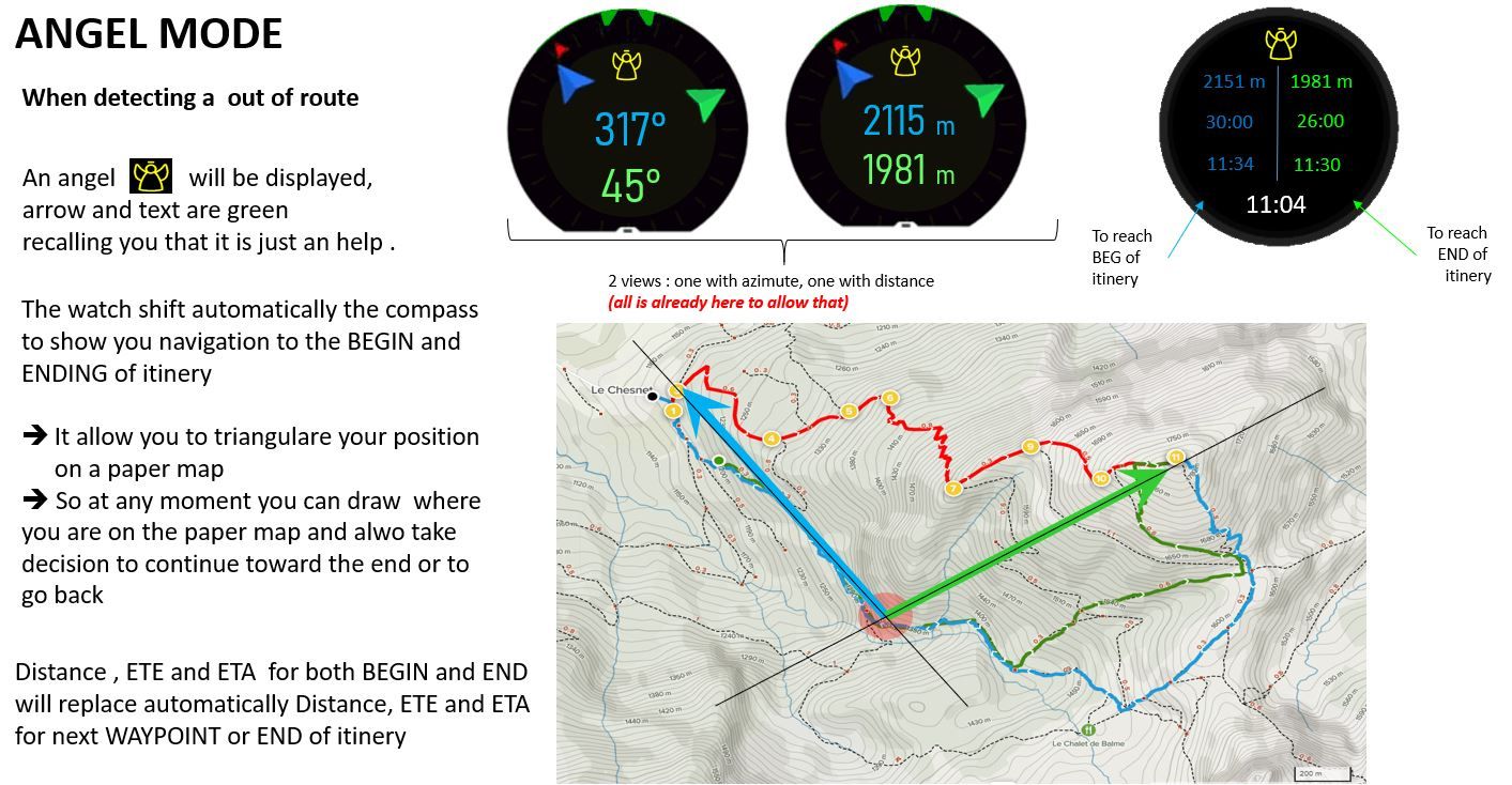
Last but not least, and to be explained to the SUUNTO team ==> one of the beauty of the idea of an ANGEL mode was that the watch will activate / commute to it automatically when it detect that the guy is out of route, so nothing to do .. it comes naturally (the information on POI being replaced by the same in a bearing navigation toward route BEGIN point and the information of end of itinery being now computed by the bearing navigation to it)
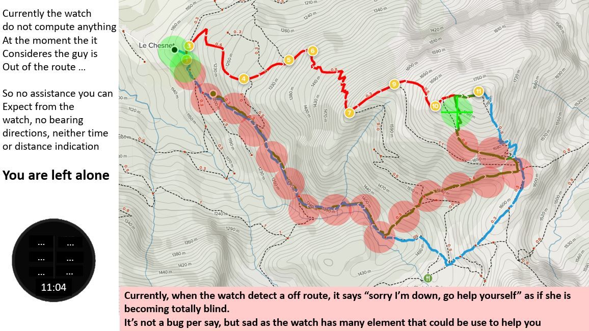
If you see what happened to me last sunday, you will realize that havign gfot this ANGEL mode, I will have able to come back straight from the beginning to the “theoritical starting point” although I was may be far of 300 or 400 m from it, and he watch just to tell me "sorry I desert, go help by yourself
Anyway … if this comes one day in a SUUNTO release on my 9 BARO, I will send you some … virtual for sure … kisses !!!
Have a nice week-end !
-
@t1sugar
Hello honestly, I do not rely on electronic devices … but if we say that … one might object us that we – all skiers – are relying on our DVA … by the way they are wrong here also … we should never think anything else than us and our causiousness will save us from an avalanche … it is the start of the death to come …
Having said that, I keep on my position that if something has to be done it is toward the BEGINNING and the ENDING point of an route because they are the sole easy waypoints that are loaded in the watch as well as placed on a paper map when you start… is will not be the case of a “shortest point to bring you back to the route” which is moving as you move also .
I agree with you on sealing … still it gives you a rough indication but it will neve be as precise as it should be, nothing more than this …
… but … between nothing today, as the watch tells you … “sorry you are out for 100 m, so I sulk !!!” and having an information … for me it makes a huge big difference, I still have the feeling that my expensive watch is with me and not just for the time and basta …The beauty of our exchange is that in fact we love this SUUNTO watch and we just want it to become even more our companion for adventure, personnaly I start to be addict to see it operating when I’m in mountain and I like to see here providing me information which I agree with you I was able to survive 40+ years of mountainering without it.
Ps on your Ps : do not worry I was not taking it as criticism. this is the beauty of this forum versus what we find over social network, here we are exchanging our ideas.
Have a nive week-end !!!
-
@mister-pyc have a nice weekend too

Community Manager / Admin @Suunto
Creator of quantified-self.io a portal that allows you to analyze your data from various providers, upload fit activity files to Suunto app, gpx routes and more… -
Hello Dimitrios
No no the week-end is not over, we are not monday, I’m just too much addict of my 9 baro !!!
I tested the S+ SAFE mode yesterday playing with my dogs … (I created a personalized freesbee exercise for when I play with them )Well … please make sure the UX team will not take it bad but …
too many informations on a such small place is killing the information
On the picture you put which is ~10x bigger on my screen that on my watch it was looking super great … the reality is different … 1) I cannot read 2) it is too much 3) the screen place is not optimiazelly occupied- why so many space used on top just to write SAFE
- the arrows are super mega small
- the altitude, elevation, current time, can be displayed already into another exercice screen
- the start time interrest can be discussed (my wife never ask me at what time we start but since how long we have started, this is why I was obliged to put duration in my exercise screen
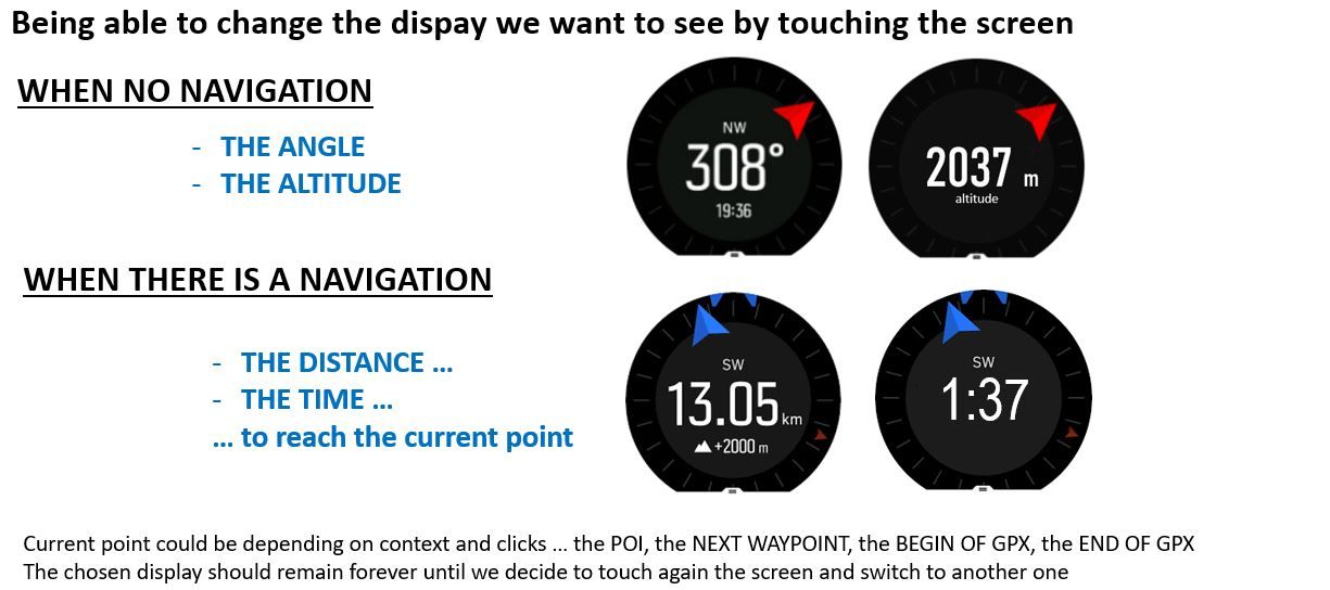
- you have a wonderful capability which is not used : I like very much that when you just press your finger on the screen, the same screen just change its secondary information so I can choose
So … let’s come back to my idea
Let’s dream that the UX team will develop this
In the exercise views
- Allow us to have the COMPASS screen
- When no navigation, just display the north with possibility when I touch on the screen to switch either the degrees or the altitude
- When there is a POI, show this big arrow to POI with when I touch the screen to swtich either to azimut to that POI, or distance to that POI or approx time to reach it
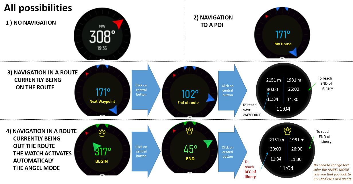
- When there is a ROUTE and I’m on it, 2 COMPASS screens instead of 1 (a click on the central button will allow me to access either the compass for next WAYPOINT) or the compass for END OF itinery … so the logic of the screen will be totally reused only differ is which point should be used
- When there is a route but I’m currently OUT OF THE ROUTE, also 2 COMPASS screens but that time with the ANGEL mode activated … the first compass showing me information on the BEGINGPX point and the second COMPASS showing me the same but on the END GPX point
the beauty being that they are the 2 fixed point that are perfectly identified bot inside the watch as well on the paper map, so allowing triangulation
An alternative, will have been to have a new COMPASS screen able to show 2 directions at the same time and that could be used for pointing either the next waypoint + end of gpx when I’m on the route or switched to begin and end of gpx when I’m in ANGEL mode.
Advantage here is 1 single screen to add to exercise, possible drawback you need to use 2 colors blue/green to distinguish the arrow and the information displayed in the center … color-blidn people will tell you that they cannot use the screen (hence even if I like a lot this idea of a single screen I may prefer finally to have 2 – BTW simplier to develop as already in place)Illustrated it gives this :
-
Why not to navigate to closest part of the route? If i do 20km hike and get lost in middle. It is much more convinient to navigate back on path rather than 10km away to start or end of road. I am not sure with S9 navigation but with Ambit series there was possibility to skip to next waypoint so it was possible to make you go to next waypoint on map rather than to closest one. Don’t see much point in navigating back to start of route when it could be 10km away but you are only 500m from route. It is much more safe to navigate you just back to correct route. Thats my opinion.
-
It was my original thinking at the beginning. but it is a false good idee …
Why ?
Multiple reasons here
-
it force Suunto for a more complex computation they have to do a geometrical mathematical computation to identify this point (Ok it is “just” mathematics but such computation has to be done regularly to reactualize this point
-
depending on where you are, it will give you each time a different point on your route, so a point that you have no idea where it is on a paper map … you cannot position this “computed” point on a paper map … so your paper map is of no use.
In reverse looking to BEG and END points systematically solve all the above situations : much easier to compute (no copmputation in fact they are in the GPX), fix point so you can see them on the map and jsut drawing the angles (also distance if you are aligned between where you are and the BEG and END) allow you to precisely put where you are on the paper map
Last but not least, such mode is not to give you directions to go, but indicattion on the map, why … because between you and the point you may have not idea about the danger that exist, the same by the way with your computed nearest point.
So I came back from this and I much more prefer the BEG and END
Suunto ca do this super easily and we might have it in a next coming upgrade.Please tell me what you think about my approach
All is possible in IT
Driven by you fear you stay on the ground, driven by your dreams you fly -
-
@mister-pyc said in ANGEL MODE... When your watch detect you are lost and are out of route:
nearest point.So I came back from this and I much more prefer the BEG and END
Suunto ca do this super easily and we might have it in a next coming upgrade.Please tell me what you think about my approach
All this for that conclusion 🤪?
Back from beginning is already implemented, and if you prepare your route well enough, you can have saved end of route POI and you are OK.
SSU (retired), SV1, SV2
Wife : S9PP
SA: Always the latest beta :)
Android + Galaxy S205G -
@mister-pyc i don’t think there are some complex calculations. You can navigate back to point where you got off route. But i think this is already posible using navigate back function in breadcrumbs screen. If you need navigate to begining or end of the route, if you are lost than direct navigation to begining or end can bring you to hard terrain, clifs etc. I think much safer is navigate back trough already known terrain. But you can save POI if you need this kind of navigation.
I would like to see first improvement of some already implemented feature before, than bringing new ones since this request is already possible to achieve with POI.
For example sleep tracking had problems to recognize correct wake up time. It rather recognize get up from bed only.
Recently removed toggle mode for backlight.
Missing possibility to use multiple graphs in custom sports mode. Old ambit allowed multiple graph screens per sports mode.
Multiple bike pods paired (people with two bikes can use only bikepod on one bike or pair pod every time)
And there is more to fix or improve.
Please don’t take this personally, just my opinion.
Suunto Ambit 2 > Suunto 5 > Suunto Race 2
-
@mff73 said in ANGEL MODE... When your watch detect you are lost and are out of route:
inning is already implemented,
The problem is elsewhere … today if you see my example, the watch acted as if she was a kid or my wife sulking because I was just more than 100 m far from the route all along.
Your rq is correct, I could have also stored the BEG and END or my route as POI (remember the BEG also because in my example I was not precisely at the BEG I was thinking). this is
- useless as already the GPX have them – open a GPX in a notepad you will see –
- hence consuming memory slot for nothing 3
- having stored them, count the number of manipulation it will requires you to locate yourself with these 2 points and not this angel mode. you will have to ask the navigation to BEG, go to compass, then ask navigation to END, go to compass, then ask again the navigation to your route … here you will have he 2 angles and distance straight immediately by a simple central click
-
Hello Tomas,
Do not worry, in this forum for the first time, I saw only gentlemen discussing and sometimes challenging each others but never mock wickely the others … very different from social networks
I’m an IT engineer.
If I was having access to the SUUNTO code, developing this ANGEL mode will have been a matter of 1 or 2 days max. the watch is on a route, so I can find easily in its GPX file its first waypoint and last waypoint, the COMPASS is already developed, so I just have to instantiate it 2 times on a click on central button (one time for BEG, one for END), the computation of distance, ETE, ETA is already here on BEARING navigation, I reuse it on these 2 points and put results in the fields of POI and end of itinery is the guy was displaying them in one of his screen – otherwise he will just have he azimut from the compass) … it remain the display of the angel icon …
That’s it.
So this will not damage the development effortConcerning your list of features … I have also plenty of others which I feel important that differs from yours :
- Revisit the screens to allow better lisibility for visualy impaired people
- Faster access to the compass and have the possibility to add it as a screen of exercise mode (even if there is no navigation currently)
- Possibility to change sort order of menus (for example move up altimeter)
- This beautiful SUUNTO plus weather screen (or a new screen on weather forecast) available in watch and exercice modes.
- Better display when pressing on center button (not only the date, time battery) but for example ALTIMETER, COMPASS, WEATHER, ALARM
So here it is depending a lot on the way we do sports. I personnaly do not care of teh watch to indicate me my sleeping, stress, or to pods. I’m just a mountainers, not a runner.
-
@mister-pyc said in ANGEL MODE... When your watch detect you are lost and are out of route:
If I was having access to the SUUNTO code, developing this ANGEL mode will have been a matter of 1 or 2 days max.
Maybe 1 month
-
@dimitrios-kanellopoulos said in ANGEL MODE... When your watch detect you are lost and are out of route:
@mister-pyc said in ANGEL MODE... When your watch detect you are lost and are out of route:
If I was having access to the SUUNTO code, developing this ANGEL mode will have been a matter of 1 or 2 days max.
Maybe 1 month
Plus the testing on all conditions on various devices no?
-
@andré-faria that is afterwards. About 2-3 weeks.
Community Manager / Admin @Suunto
Creator of quantified-self.io a portal that allows you to analyze your data from various providers, upload fit activity files to Suunto app, gpx routes and more… -
Hope you are you kidding ???
… we are no more in waterfall model but now in Agile … so is it not a matter of 1 sprint ?
I’m pushing you a little bit … but for a POC 1 or 2 days should suffise, after … for a LIVE mode … you are right there are some more tests to perform and may be some fine tuning …But the point is the following :
Suunto dev folks have absolutely all the technical elements :
- The compass in which you set a bearing position and it does the job
no test needed here it works already, isnt’it - the GPX loaded
- the boolean telling you if YES or NO you are out of route …
- the biggest difficulties is to search in the GPX file for the last way point (the first one being trivial) … I hope you agree with me it is still simple … and … there is not yet the COMPASS displayed in the exercise view, so effectivelly to be added.
- No over complexity at first glance, no compass with 2 arrows pointing in the same screen BEGIN and END even if I like it
- No over complexity to compute the nearest point on the route to go straight, this is a false good idea
some pseudo code most surely too simple I admit
In the code that revisit if out of route or not
        AngelMode = false
	Switch Navigation mode is
	{
		= NO
		{
			Compass 1 Point = null
			Compass 2 Point = null
		}
		= Bearing to a POI
		{
			Compass 1 Point = this point
			Compass 2 Point = null
		}
		= in a Route
		{
			if OutOfRoute detected
			{
				AngelMode = true
				Compass 1 Point = GPX BEGIN point
				Compass 2 Point = GPX END point
			}
			else
			{
				Compass 1 Point = GPX next way point
				Compass 2 Point = GPX END Point
			}
		}
	}
.
In the code that manage the click on Central button
.Switch next_screen_to_display is { = Compass 1 { DISPLAY_COMPASS_SCREEN if compass point 1 <> null { show bearing navigation to point 1 if angel_mode = true { show Angel icon } } else { just show the classical compass } } = Compass 2 { if navigation on route is false { Move to the screen which is after // A second compass is useless if not on a route } else { DISPLAY_COMPASS_SCREEN show bearing navigation to point 2 if angel_mode = true { show Angel icon } } } = A screen which has distance/ETE/ETA POI or Itinery { if angel_mode = false { classical computation of these info } if angel_mode = true { Distance, ETE, ETA of POI = bearing computation formula to compass 1 point Distance, ETE, ETA of POI = bearing computation formula to compass 2 point show Angel icon } } } - The compass in which you set a bearing position and it does the job
-
@mister-pyc well yes 1 sprint (it’s 1month) and yes 2 days poc.
But that as a suunto plus I suppose with some already template.
That said I hope Suunto brings the suunto plus to us developers via apis etc. Then it’s end of story.
Community Manager / Admin @Suunto
Creator of quantified-self.io a portal that allows you to analyze your data from various providers, upload fit activity files to Suunto app, gpx routes and more…