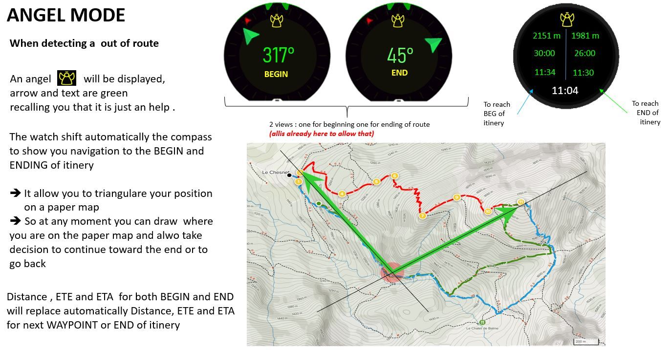
ANGEL MODE... When your watch detect you are lost and are out of route
-
Hope you are you kidding ???
") … we are no more in waterfall model but now in Agile … so is it not a matter of 1 sprint ?
… we are no more in waterfall model but now in Agile … so is it not a matter of 1 sprint ? ")
I’m pushing you a little bit … but for a POC 1 or 2 days should suffise, after … for a LIVE mode … you are right there are some more tests to perform and may be some fine tuning …But the point is the following :
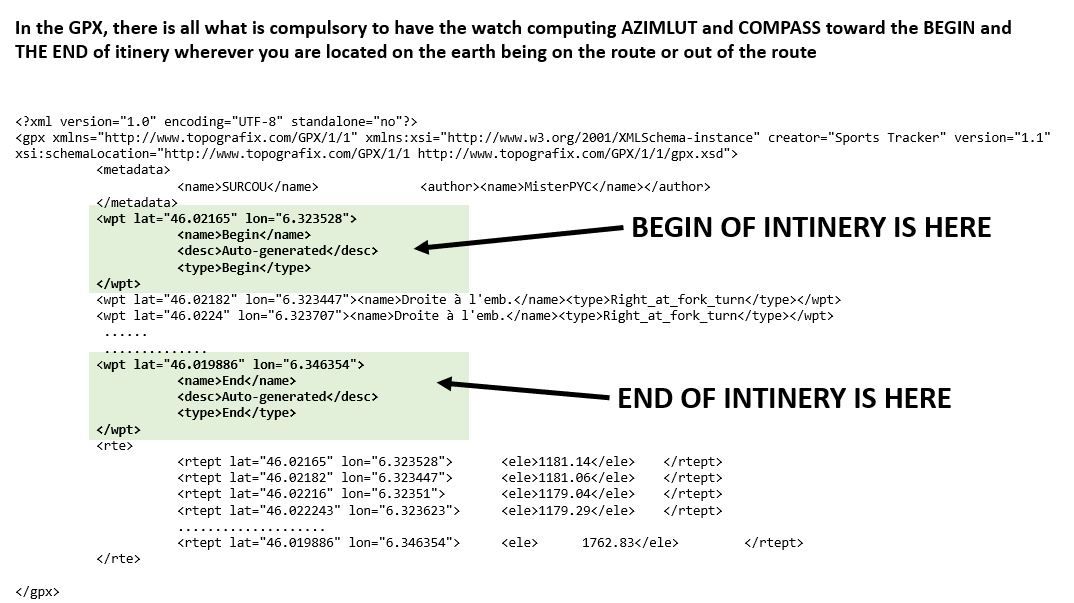
Suunto dev folks have absolutely all the technical elements :
- The compass in which you set a bearing position and it does the job
no test needed here it works already, isnt’it - the GPX loaded
- the boolean telling you if YES or NO you are out of route …
- the biggest difficulties is to search in the GPX file for the last way point (the first one being trivial) … I hope you agree with me it is still simple … and … there is not yet the COMPASS displayed in the exercise view, so effectivelly to be added.
- No over complexity at first glance, no compass with 2 arrows pointing in the same screen BEGIN and END even if I like it
- No over complexity to compute the nearest point on the route to go straight, this is a false good idea
some pseudo code most surely too simple I admit
In the code that revisit if out of route or not
        AngelMode = false
	Switch Navigation mode is
	{
		= NO
		{
			Compass 1 Point = null
			Compass 2 Point = null
		}
		= Bearing to a POI
		{
			Compass 1 Point = this point
			Compass 2 Point = null
		}
		= in a Route
		{
			if OutOfRoute detected
			{
				AngelMode = true
				Compass 1 Point = GPX BEGIN point
				Compass 2 Point = GPX END point
			}
			else
			{
				Compass 1 Point = GPX next way point
				Compass 2 Point = GPX END Point
			}
		}
	}
.
In the code that manage the click on Central button
.Switch next_screen_to_display is { = Compass 1 { DISPLAY_COMPASS_SCREEN if compass point 1 <> null { show bearing navigation to point 1 if angel_mode = true { show Angel icon } } else { just show the classical compass } } = Compass 2 { if navigation on route is false { Move to the screen which is after // A second compass is useless if not on a route } else { DISPLAY_COMPASS_SCREEN show bearing navigation to point 2 if angel_mode = true { show Angel icon } } } = A screen which has distance/ETE/ETA POI or Itinery { if angel_mode = false { classical computation of these info } if angel_mode = true { Distance, ETE, ETA of POI = bearing computation formula to compass 1 point Distance, ETE, ETA of POI = bearing computation formula to compass 2 point show Angel icon } } } - The compass in which you set a bearing position and it does the job
-
@mister-pyc well yes 1 sprint (it’s 1month) and yes 2 days poc.
But that as a suunto plus I suppose with some already template.
That said I hope Suunto brings the suunto plus to us developers via apis etc. Then it’s end of story.
Community Manager / Admin @Suunto
Creator of quantified-self.io a portal that allows you to analyze your data from various providers, upload fit activity files to Suunto app, gpx routes and more… -
@dimitrios-kanellopoulos said in ANGEL MODE... When your watch detect you are lost and are out of route:
@mister-pyc well yes 1 sprint (it’s 1month) and yes 2 days poc.
But that as a suunto plus I suppose with some already template.
That said I hope Suunto brings the suunto plus to us developers via apis etc. Then it’s end of story.
Aïe aïe aïe it should be something that comes automatically on detection out of route and not S+ mode decked at beg of a navigation … Otherwise the benefit of this is lost.
I explain … the Beauty of navigation on a route is that your will have the full Gpx trace when you are back at home, no matter having been a good or an improvised one. Hence if you are out of route you should not stop your navigation for starting it again this time with a S+ angel mode … this mode should come naturally and disappear naturally when the watch is back on the routeAll is possible in IT
Driven by you fear you stay on the ground, driven by your dreams you fly -
@mister-pyc why not though? Sure, automatic suggestion might be more pleasant. But manual s+ mode allows for better control from users perspective. Then, if it’s used often enough it might be integrated on a deeper level. Seems to be a good enough compromise, no?
-
@mister-pyc well I meant it in the sense of adding your own widgets / s+ / code etc. With some logic.
In this way all users can build what they want no?
Community Manager / Admin @Suunto
Creator of quantified-self.io a portal that allows you to analyze your data from various providers, upload fit activity files to Suunto app, gpx routes and more… -
@dimitrios-kanellopoulos wow this would be amazing! Could this theoretically be possible? I thought it couldn’t due to risk of having non-optimized apps.
-
@дима-мельниченко why not possible. It’s all a matter of prioritization.
Community Manager / Admin @Suunto
Creator of quantified-self.io a portal that allows you to analyze your data from various providers, upload fit activity files to Suunto app, gpx routes and more… -
@dimitrios-kanellopoulos let me rephrase:)
I thought it wasn’t probable. But I would definitely dig writing own s+ apps. And with such lively forum, one could come up with really useful stuff. -
@dimitrios-kanellopoulos this would be great feature to have. Old ambit has some possibility to write custom apps. This could be great. And i like idea of angel mode implemented as Suunto+ so only when activates it will show up. I know that direct integration would be great for some users (mountainers) but it will bring new not needed complexity to sports modes for others. Now user interface is simple enough and Suunto+ can solve this. Maybe possibility to allow multiple suunto+ screens at once would be great.
Suunto Ambit 2 > Suunto 5 > Suunto Race 2
-
@tomas5 I mean if implemented automatically outside of s+, it could be managed by adding a toggle in the navigation submenu.
Otherwise I agree. -
@дима-мельниченко
There is 2 points here for not a good idea of a Suunto plus
-
The problem of the S+ is that is it a choice to be done before you start the exercise and not in the middle when you face a no route situation, it will force you to stop your recording, engage again the same itinery with this time activating the s+ … not practical for a situation that the watch detected by herself (remember the watch is telling you that you are out of route, so can easily switch
-
the initial idea is that you can stay for a long time out of route and in such situation you watch is sulk like a kid or my wife when you decided not to go where they want
and give you zero information anymore …
See my example which started all my thinking of this angel mode here :. https://forum.suunto.com/topic/6751/is-it-a-navigation-bug-distance-ete-eta-remained-empty-despite-i-was-not-far-from-the-itinery/53?_=1626585265073
Believe me … I happened when I was promoting the watch to a friend, precisely on this walk … and all along the watch was not more indicating anything about at minima the END waypoint of the itinery … which I hope you will agree with me, even if she was not able to compute following the forecasted route as we were no more on it, at minima she could have switched automatically to bearing navigation stragith to that point at least to give me indication on it.
All is possible in IT
Driven by you fear you stay on the ground, driven by your dreams you fly -
-
Hello thomas
Please see my just above answer to Дима Мельниченко which explain why I think a S+ mode is not a good idea.Your remark on integration only to some user who might need this, is a fair remark.
What about if …
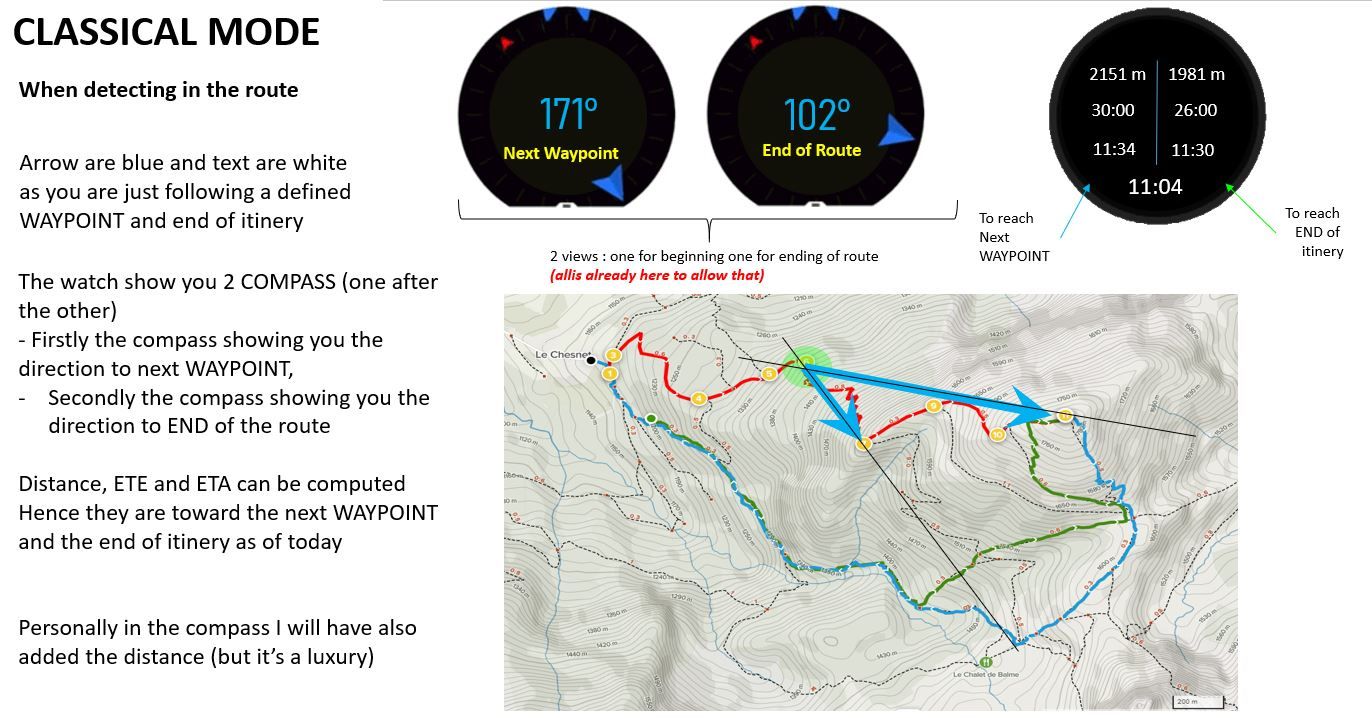
- it was you who has the possibility when you personalize the exercise screen to add a compass (I dream a little bit and assume Suunto could enhance its compass to put 2 arrows : one for the POI / END itinery or one for BEG and END of itinery in angel mode)
- In the compass parameter you can decide to activate of not the Angel mode … if so, the watch will automatically switch to it when out of route and also shift the computation of distance, ETE, ETA from POI / END itinery to BEG and END of itinery.
Doing that, the people it gives 3 possibilities
- for those not interrested by having a COMPASS in their exercice, they do not have it
- for those interrested by a COMPASS but not ANGEL mode they have it
- for ME !!! I’m super happy …
Ps : I’m sure people in 2 will come to 3 soon
All is possible in IT
Driven by you fear you stay on the ground, driven by your dreams you fly -
@mister-pyc I think we might be able to switch s+ mid activity soon, this should at least partially eliminate your conserns.
I’m not saying it’s better with s+, I’m saying it’s at least something. Or you think it’s either all in or all out? -
Hello dmytro
For sure better than nothing is always good.
You know I’m just suggesting ideas, I have no super power to strongly say “I WANT THIS LIKE THAT !!!” if tomorrow the S+ can be selected in middle of the exercise then it is a very good alternative.
So let’s revisit it in that angle and it could become like this
- the S+ option could be selected in the middle of an exercise
- we have now the possibility to add COMPASS when we personalize the exercise screens
2 possibilities here :
- either we have a new COMPASS with 2 arrows, in such case we just need to add one
- or no change on COMPASS, in that case will be great if in the exercise view we can add 2 compass (one for POI one for END of itinery)
- When we need the ANGEL mode, then we can call this S+ in the middle of the exercise and it will activate it
Going that way … there is already a S+ SAFE mode, so … may be … it could be this mode that will add the ANGEL possibilities if we select it …
it will add the S+ SAFE screen as today and automatically switch the bearing navigations from POI/newt waypoint/End itinery to BEG and END of itinery …May be a good idea.
Another suggestion
=> I wil write a small post on it : what about if there is a new navigation OPTION = Navigate to one of the course waypoints and which allow us to select a course (or if we are inside a course already then propose naturally its waypoints) and we can select 1) the BEG, 2) the END … then … eventually … the others sorted by the route
-
@mister-pyc this sounds over-engineered
Community Manager / Admin @Suunto
Creator of quantified-self.io a portal that allows you to analyze your data from various providers, upload fit activity files to Suunto app, gpx routes and more… -
I may agree with you .
I was thinking to another alternative which is far simplier .
Today we have
- navigate to a POI
- navigate on a Route
- bearing navigation
What about if we have one more possibility
- navigate to a route’s waypoint … could be call simply navigate to a waypoint
This new possibility working as follow :
When you select it, it display you the possible routes loaded on you watch and then a new screen allowing you to select one of the waypoint.
It just requires to
- have the COMPASS always available during an excercise, in any case for me this is a big miss currently. we should see the compass and in case we are navigating it should indicate the bearing informations
- develop a new screen to allow to select a waypoint of a route to navigate to
There are plenty advantages here
- such navigation can be done without stopping the exercise, which is very good
- it allow in case you start bad since the beginning, but are not too far from your forecasted route, to reach this forecasted BEGIN point
- It allow in case you are really out of route to point now the END of the route even if you were not storing it as a POI (you can be sure you forgot to do this at home ) … so at least instead of ZERO info you have some indication on how far you are from the end in a direct walk (better that the today nothing)
- if really you have the feeling to be lost … you can successivelly point the BEGIN, put the angle on the paper map, then point the END, put also the angle on the map … so you report you position on the map …
- last but not least you can use this feature as a trick … you now have a notion of library !!! so … for example … if you create a route in which you store as waypoint some interresting POI, it might not be the super good route to navigate but you have stored all the interrestign waypoints of that area into a single gpx (the first being the parking or starting refuge, the last being either the summit or the targetted refuge, and in the middle you can place some interresting places or summit you want to go …
What do you think …
We do not take advantage of this automatic switching of ANGEL mode, it take more effort to do a triangulation that was coming naturally with the ANGEL mode … but … may be it is simplier do develop … well … I do not think what I was proposing was such difficult to develop …
If there was a way to develop some POC by ourselves I will have been happy to participate here actively …
-
Hello Dimitrios.
taking your rq of over enigneering and one more time playing with my dogs … the best moment to try and think to the suunto
what about even simplier :
-
Have the possibility to add the COMPASS screen in personalized view
this for sure is a missing feature -
when you are on the compass view there is a contextual menu if we press a long time on the central button … why not to take benefit of it as follow :
When the user opened the contextual menu he will have new choices in case a route was selected :
- Navigate to the route’s start (first GPX waypoint)
- Navigate to the rout’s end (last GPX waypoint)
- Navigate again on the route (back as of today)
Doing so … no need even to add complex screens
For sure … if one day there will be 2 arrows on the COMPASS (not counting the north), then it could have been great to have one more navigation option
- Show route’s start and begin which will allow triangulation and safe positioning on paper map even in darkness , cloud or white day.
PS 1 : I think I’m done now with all the details of my suggestion …
PS 2 : we are now 3 to wait for an enhanced freesbe mode …although we are just a few meters from the house so not sure the angel mode will be necessary here
-
-
@mister-pyc said in ANGEL MODE... When your watch detect you are lost and are out of route:
Have the possibility to add the COMPASS screen in personalized view
this for sure is a missing featureyou have the north to the navigation screen actually.
I am not the one deciding on this but to me it sounds well complicated for using a sports watch, not even sure what user percentage would be using this.
Not that I am saying that this is not a good suggestion
Community Manager / Admin @Suunto
Creator of quantified-self.io a portal that allows you to analyze your data from various providers, upload fit activity files to Suunto app, gpx routes and more… -
@mister-pyc well i don’t have compas in S5 so i can’t judge this suggestion. But in excercise you can always enable navigation screen breadcrumbs and from there you can enable “navigate back”. So if you are lost this feature will navigate you back by same route you already walked. For me this is safes possible way how to get back to route if you are lost. In bad weather conditions with fog, rainfall, snowing etc. it should be safes possibility how to get back. Because you already walked that “route” so there is no risk getting into some cliffs or other danger. But sure it isn’t always closest path to safety. But in my opinion it is safest.
But if this screen should be configurable, than it will not bring any complexity for users which don’t want to use it so i think it is ok.
Suunto Ambit 2 > Suunto 5 > Suunto Race 2
-
@dimitrios-kanellopoulos said in ANGEL MODE... When your watch detect you are lost and are out of route:
you have the north to the navigation screen actually.
you are very correct for the north … still one rq : the arrows in the “map” as well as the SAFE screen btw are super hyper mega small … may be a little bit bigger will have been better … hence also why I made this suggestion to have the real compass screen.
Concerning my suggestion, do not worry … it was already good for the brain to think of this and challenge ideas here.
Still think about the idea to navigate to the BEGIN or END waypoint.
Having got this I will have realized much easier that my begin point was in fact not so far, so could I have join it … or … if finally I prefered to stay on my “new” out of route walk I still could have a view on my targetted finish point instead of zero information in distance, ETE, ETA, direction from it all along the travel.