Race - very strange map elevation for canoe route
-
@mikekoski490 Just did it again. 13k route on ocean from start to finish. Elevation gain 1200, descent 80. (?)
Past Suuntos: X-Lander/Observer/T6/X9/X10/X6HR/CORES/Ambits/Spartan/9P/9PP Ti/Vertical Ti
Current: Suunto Race Ti
Past other GPS watches: Polar Vantage V; Garmin 6X Pro Solar; Coros Vertix 2
Suunto App running on Google Pixel 8/Android 14
-
on ocean there should be “sea” level fluctuations caused by long waves, but at the end ups and downs should give similar gain/loss values … and in any case 29’000 m is quite a lot!
-
@mikekoski490
i might guess (without knowing) that SA is displaying a logic ascent for a route according to sportsmode, but after that, while transfering such route to the watch, “real” altitudes might have been transfered with “real” altitude loss (thus deep abyssal ones") )
)
Just a guess.
Maybe exporting route gpx could show this theory ?
-
@mikekoski490 said in Race - very strange map elevation for canoe route:
Just did it again. 13k route on ocean from start to finish. Elevation gain 1200, descent 80.
Is this measured by the device? Could it be that wind, water and/or jacket is influcening the pressure sensor?
(https://forum.suunto.com/topic/11142/suunto-vertical-altitude-difference-problem/6)
-
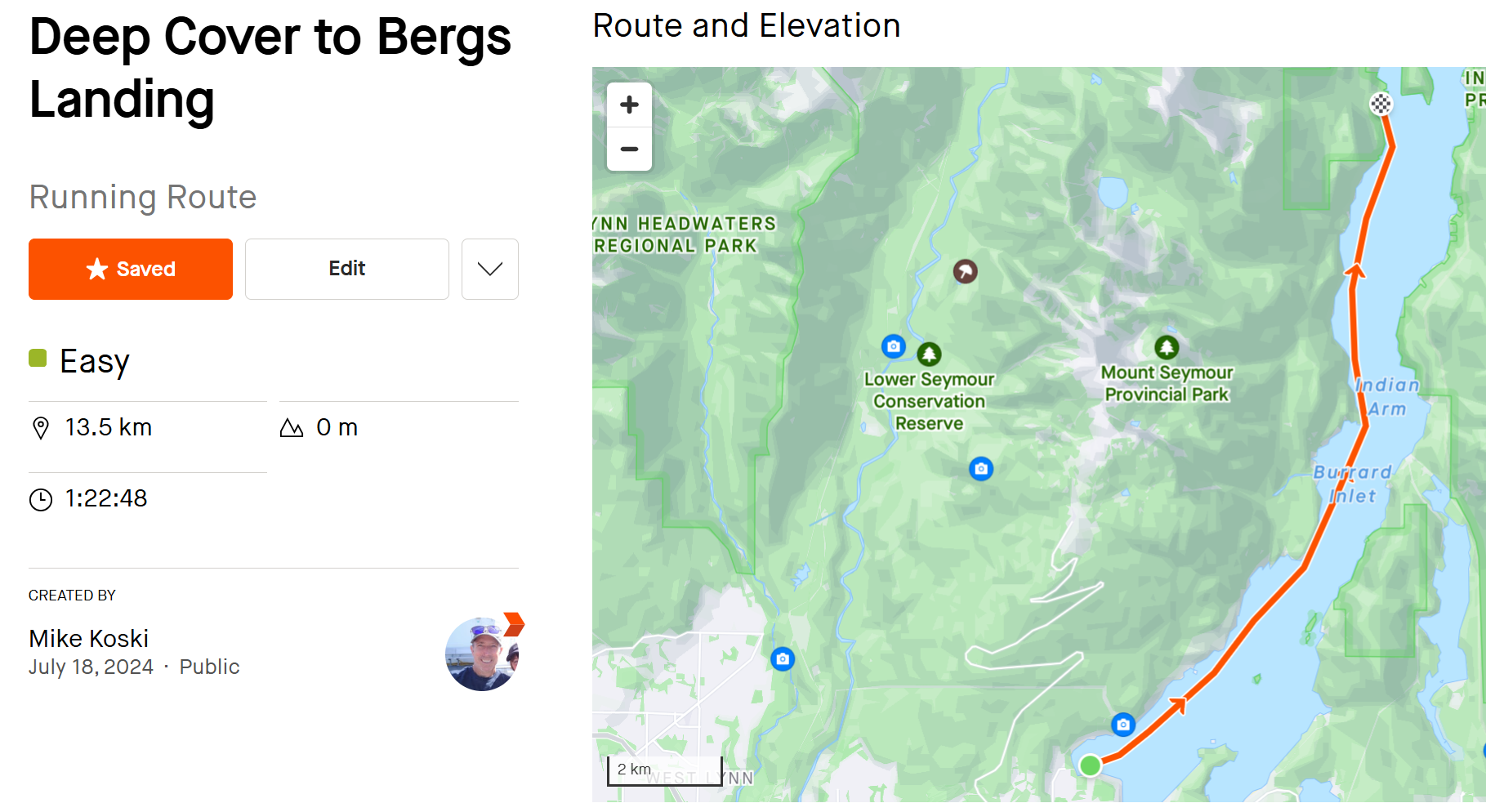
@surfboomerang Hi. Thanks all for the replies I appreciate it! I realized I may not have explained this correctly. This is about making a route in SA that is a paddling route on the ocean, to be used with the Suunto Race - not using the Suunto Ocean diving.
For some reason, no matter how many times I try, SA is assigning huge elevation to my completely flat track on the ocean. At no point does my track touch or hit land and its in the middle of an ocean channel (13km). Just wierd. I cant seem to draw the route without SA adding elevation gain or loss.
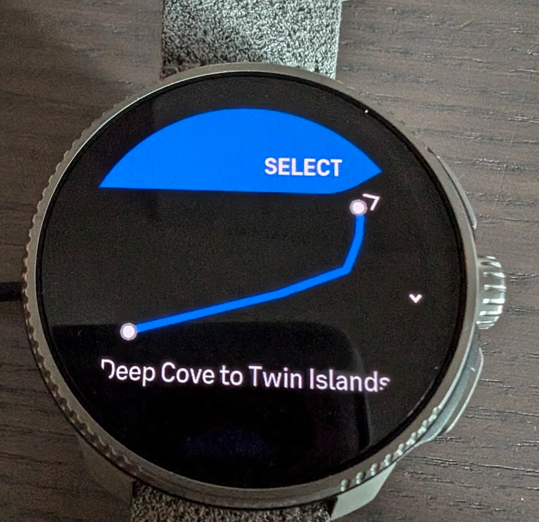
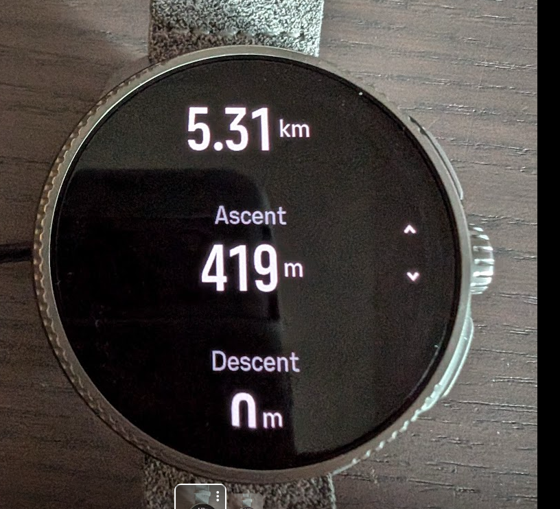
Here is a small example: I made a route starting about 50 meters from shore, to paddle to a small island 5kms away, with the route ending 50 meters from shore (the Twin island itself has a max altitude of 15 meters).
Suunto shows my flat paddle route gaining 419m.
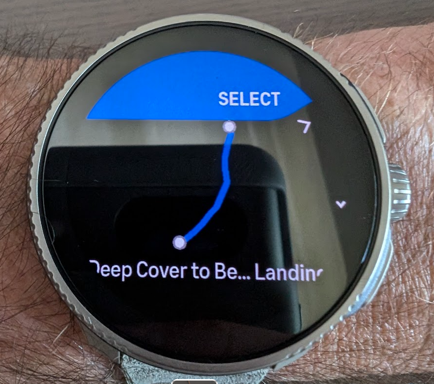
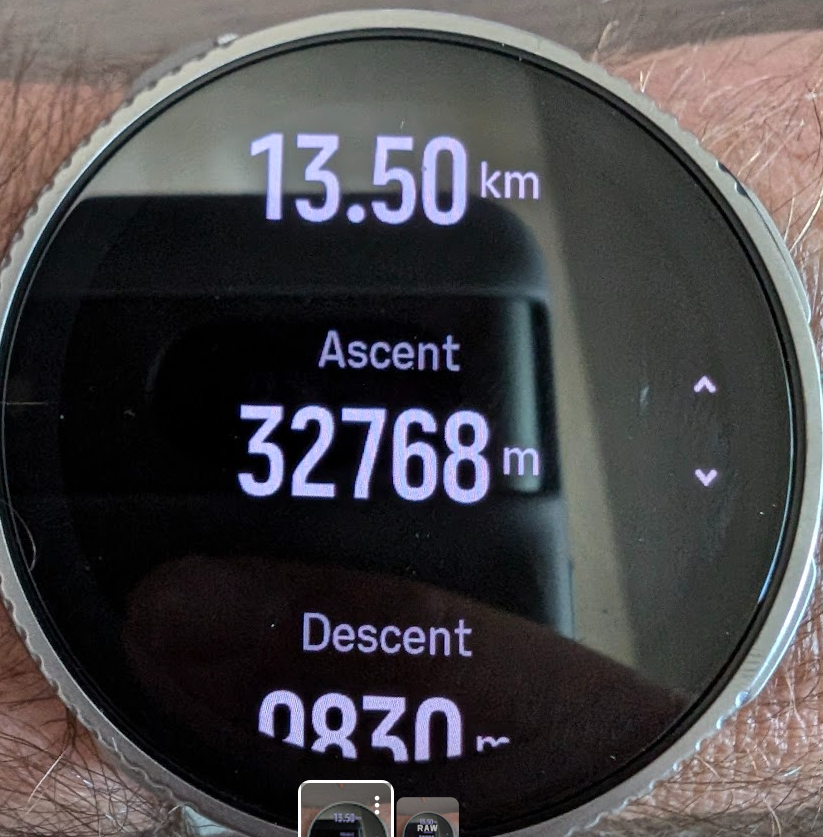
Ive deleted my route that was a 13km paddle, but the first version of the route had me losing 29,000 meters. NOTE: Here is the same route (13km paddle) drawn in Strava showing as it should 0M elevation gain, so its definitely a glitch in SA route mapping and how it shows up in Suunto Race.
Ive saved this version as a .gpx file and downloaded to my Suunto Race, and will likely use
the route mapping in Strava going forward, as here is the same route drawn in SA, using the same parameters as Strava, showing an almost 1000m elevation gain. My only question is does SA do the same when elevation matters?: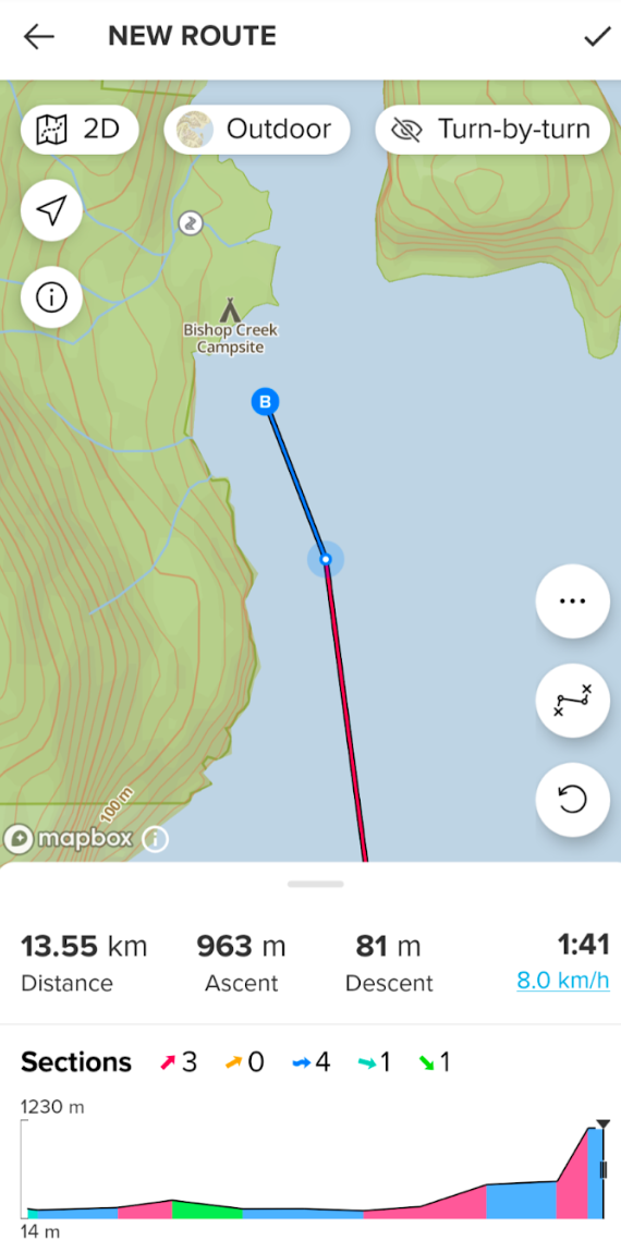
Past Suuntos: X-Lander/Observer/T6/X9/X10/X6HR/CORES/Ambits/Spartan/9P/9PP Ti/Vertical Ti
Current: Suunto Race Ti
Past other GPS watches: Polar Vantage V; Garmin 6X Pro Solar; Coros Vertix 2
Suunto App running on Google Pixel 8/Android 14
-
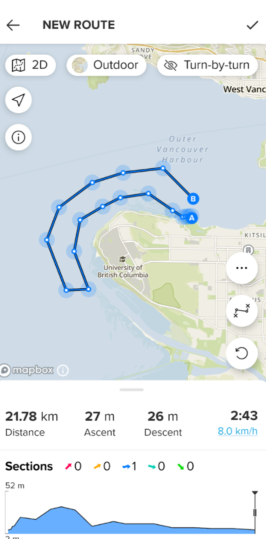
@mikekoski490 No idea where the altitude information is coming from, but when I draw your route in SA I also get ascent values of approximately 1000m. When I draw the same route in plotaroute.com I get an ascent of 0m.
Both are using openstreetmap afaik.
-
@mikekoski490
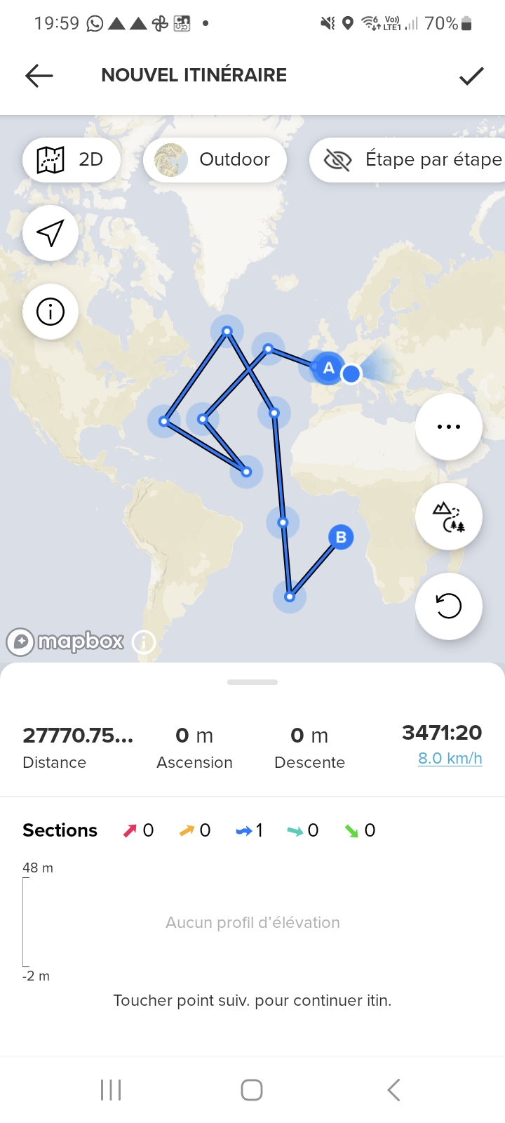
I also try, and draw a route near French coast : 0m ascent or descent.
I extended it with a 27000km trip across oceans , still 0m
Maybe some small areas have issues.
Suunto Spartan Ultra (since 2016) FW: 2.8.24 (retired)
Suunto Vertical all black
Wife : S9PP
SA: Always the latest beta :)
Android 13, Galaxy S205G -
@Mff73 Huh. Wierd. Thanks!
Past Suuntos: X-Lander/Observer/T6/X9/X10/X6HR/CORES/Ambits/Spartan/9P/9PP Ti/Vertical Ti
Current: Suunto Race Ti
Past other GPS watches: Polar Vantage V; Garmin 6X Pro Solar; Coros Vertix 2
Suunto App running on Google Pixel 8/Android 14
-
@Mff73 I completely changed the location to another area, and same thing. Creating a route for a short paddle gives an elevation gain. The more I extend the map, the more elevation gain.
-
@mikekoski490 OH, and I just noticed. The .gpx map that I downloaded from Strava? The one that correctly provided 0m elevation gain or loss when I created the route in Strava? Here is how it converted to when I review the route in my Suunto Race: