Angel mode - use your watch as a goniometer with 2 POI and a 1/25000 paper map
-
I call this mode ANGEL MODE
because your watch could become your angel to help you to locate yourself quite precisely and also take decision to pursue or stop go back in case of difficultiesIt’s something I already explained few years back which receive some good answers but still not done.
What is this ANGEL mode : super simple and super simple to to in reality if instead to set one single POI SUUNTO offer us the posibility to set 2 POI and them to just adapt a little bit 2 things : measures (Distance, ETA, ETA to POI, itinary) and compass view
Seems useless and old school as here we are talking of paper map, but real mountain guide are still using old school maps . and if you are totally lost in fog situation, how can you locate yourself on a map ???
Here SUUNTO could offer a wonderful feature. Imagine that you have recorded some very remarquable points prior to start your journey. For example some very high mountains which also are easy to find on the map
If instead of one single POI, SUUNTO allow to set 2 and to show them with a different colored arrow, then it create an angle between the watch, the north and also these 2 POI and with such angle put the same manner on the paper map you can easily located yourself.
No watch offer this. But any military person will tell you it’s awesome
My idea :
If you can set 2 POI instead of one, then you can use your screen in this mannerDistance to POI = Distance to POI n° 1
ETA POI = ETA to POI n°1
ETE POI = ETE to POI n°1 Distance to Itinary = Distance to POI n° 2
ETA to itinary = ETA to POI n°2
ETE to itinary = ETE to POI n°2
This will allow to choose in case you are in difficulties if this is better to walk back to POI 1 which could be your starting point or still to continue to POI 2 which could be the refuge you want to reach and where you will find some help
Also in the COMPASS view, the the direction 2 POI will be visible POI 1 with a BLUE arrow and POI 2 with a Green Arrow (north remaining red) and in the middle of the screen you can see the angle between these 2 direction (in white)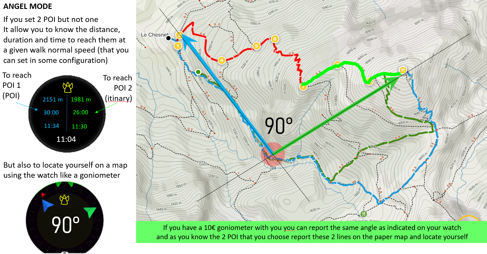
-
Hey @Mister-PYC ! Thanks for sharing the ideas with the illustrations.
Would you agree that the ultimate goal is to locate yourself on the field? Would it not require fewer steps if you just took the actual coordinates from the watch and plotted on a map? Under duress, it would be more work to triangulate, no? Arguably, having the user hand plot the items under stress is likely to cause cascading risks if they marked the points incorrectly on the map.
Triangulation would also require that those two points are on the same “page” of the map so you can plot them. If they are out of view for whatever reason, then the error rate in the plot will also rise.
High quality maps should have coordinate grids or axes, and if the map doesn’t have axes, or a good scale and labels, then it requires more work to get that triangle to scale, which would be a higher cognitive load in a stressful situation. If a person carries a map without coord’s but with pre-marked points, then that should be considered as something to improve during trip planning.
The coord’s are obtained using the “safe” S+ app, or the current location under the compass screen. I’d love to see a cleaner and more robust iteration of the S+ screen, using your feedback above.
What do you think?
-
@Umer-Javed
my 2 cents here :Still a triangulation method gives already very accurate position, this is typically what we were doing during my army with 2 visible points. Nowadays watches with GPS allow to extend this principle even when there is fog and you 2 visibles points are … not visible
So tirangulation gives a very good position, still approximative and it is more for the pleasure to do itConcerning the SUUNTO + SAFE sceen, it is a nice one but I do not like it … gps coordinates are not such easy to use. do you know WHAT 3 WORD ? … my dream is that there is a revision of this widget with also the capacity in these S+ screens to use the scroll and if such to separate the screen into 3 : 1) the current position with W3W 2) the current position with GPS coordinate 3) the initial position with GPS coordinate, distance and direction .
Doing such it will allow to use bigger fonts…Go visit this : https://what3words.com/
Why I suggest W3W ? is you are in difficulties or in any other reasons, for example you want to give your position to a friend … not so many people talk GPS coordinate … also they might not hear well and a small difference (so a small error / misunderstanding) in GPS coordinate can generate a big error on the map, instead giving 3 words to your friend allow him to simply use his own phone and locate you, so later to indicate to anybody where you are, or … to go to you
this will work in mountain as well as in a town or … a big supermarket
") … and you with a nice phone or a very old one
… and you with a nice phone or a very old onemy idea also here is : let’s PLAY with this watch but not just find it beautiful
so totaly agree with you