New SMART barometric algorithm
-
From software update announcement:
-
Initial threshold reduced to 2 m (previously 3 m)
-
Meter-by-meter measurement after the initial threshold
-
New air/water filtering (wind, rain, humidity, friction)
-
Elimination of false ascent and descent spikes
-
Improved altimeter accuracy and stability
In very strong winds, the problem still persists, but the error is much smaller. In this case, it was about 250m too high. According to the Suunto Vertical, 1185m – it should be around 900-950m.
I’m generally satisfied; previously, my ascent totals were often over 1000m higher than the actual total. But there’s still room for improvement.
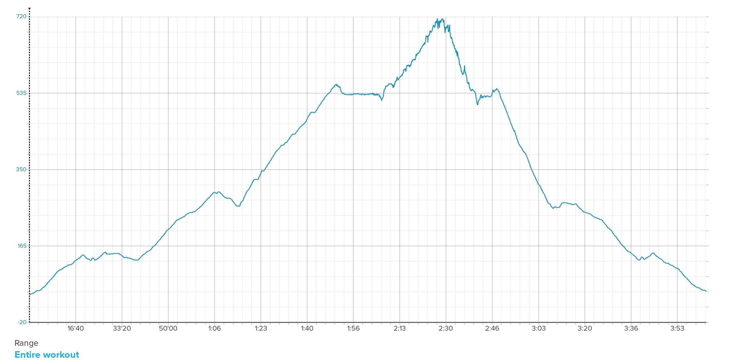
It can be clearly visible at the upper part of the mountain, where the wind was definitely the strongest, that the graph is very jagged and hence the inflated results.
-
-
@maszop said in New SMART barometric algorithm:
Meter-by-meter measurement after the initial threshold
By the way, I find it to be foot by foot rather than meter by meter when the watch is configured in imperial units. One foot = 30.5 cm.
-
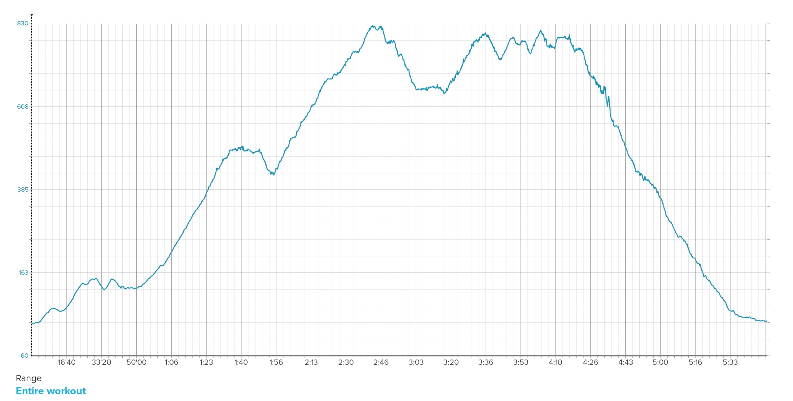
Today I had the opportunity to test it more thoroughly in strong winds. The problem persists, and its scale is still significant. Suunto reports 2,118 meters of ascent, instead of the actual about 1,500 meters.
I’m not convinced by the constant responses that it’s impossible to calculate accurately in windy conditions, because the Garmin Fenix 8, in identical conditions, indicated 1,600 meters, which is already acceptable accuracy.
-
Also there should be the ‘FusedAlti’ thing that helps in such cases. But as FusedTrack is gone, maybe thats also the case with FusedAlti?
-
Walked to the summit of Pen y Fan today. The summit is 886m and my Race read 887 at the top, without prior calibration. Not too bad
")
Suunto Race Titanium
Suunto Ambit3 Peak
Polar H10
Polar OH1 -
@wakarimasen This has nothing to do with measuring altitude itself — that’s never been a problem with Suunto.
Look at the top part of the altitude graph, and you’ll see a jagged line with multiple little, sharp peaks (caused by strong wind) that add up, giving absurd ascent and descent totals.
It’s a bit better since the last update, but the results are still absurd and essentially useless for any analysis. -
@wakarimasen I believe he means accent. Suunto is normally spot on for the exact altitude.
As a cyclist I’ll go out with a group and the accent totals can vary greatly even if people have the exact model.
-
@maszop said in New SMART barometric algorithm:
Garmin Fenix 8, in identical conditions, indicated 1,600 meters, which is already acceptable accuracy.
Higher end Garmin watches use in-watch elevation database to cross-reference barometric altitude. I think that is called DEM - digital elevation model.
-
@sky-runner It’s been several years since I reported this, and the problem still hasn’t been resolved (despite Suunto’s assurances).
Perhaps some other mechanism besides FusedAlti is needed. Currently, this is yet another example of Suunto drastically lagging behind the competition. -
@maszop I’ve had a pretty good experience after the last software software update. The ascent/descent is a bit more accurate than before.
Here is a graph from today’s trail run. There was a strong wind at the top (above 2500 ft), but there is no jaggedness:
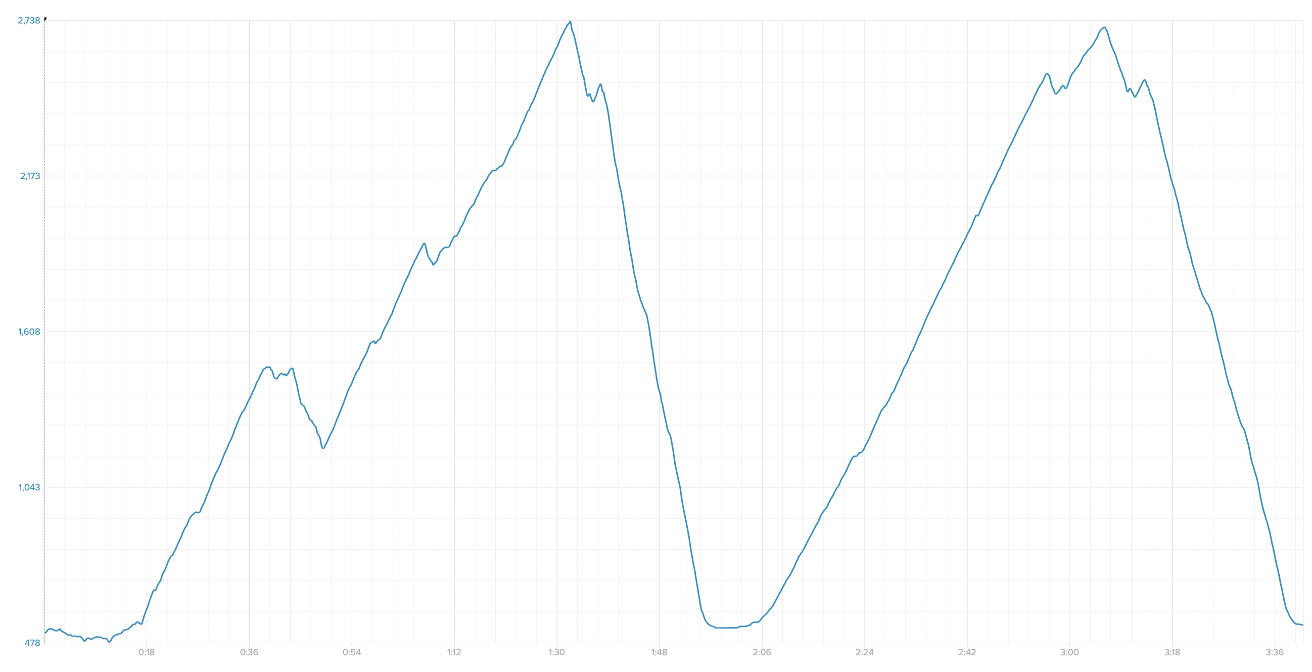
This trail run had 5100 ft (1550m) of ascent, which is very close to what I expected. By the way, in my experience the estimated ascent shown in the Suunto App for the route is always at least 10-15% lower than actual, if you compare to that. But I agree that in your case there is a clear jaggedness at the top, which likely adds extra ascent.
-
@sky-runner Before the last update, I had over 3,000 meters of altitude there (very windy conditions), so there’s certainly an improvement, but it’s still unacceptable.
In calm conditions, it’s accurate – around 1,500 meters.According to SuuntoApp, it should be around 1,000 meters, but SuuntoApp estimates should never be taken seriously. This is another place where Suunto completely fails.
-
@maszop said in New SMART barometric algorithm:
@wakarimasen This has nothing to do with measuring altitude itself — that’s never been a problem with Suunto.
Look at the top part of the altitude graph, and you’ll see a jagged line with multiple little, sharp peaks (caused by strong wind) that add up, giving absurd ascent and descent totals.
It’s a bit better since the last update, but the results are still absurd and essentially useless for any analysis.Understood. Ascent/ descent isn’t so important for me, I guess. I’m just pleased to get to the top, and know how far there is to go on the way there.
 My Polar watch ‘over-read’ by 10m at the summit, for comparison.