• Recent
  • Tags
  • Popular
  • Users
  • Groups
  • Register
  • Login
Suunto app Forum Suunto Community Forum
  • Recent
  • Tags
  • Popular
  • Users
  • Groups
  • Register
  • Login

What do you expect from the next update?

Scheduled Pinned Locked Moved Suunto Vertical
615 Posts 164 Posters 66.4k Views
Loading More Posts
  • Oldest to Newest
  • Newest to Oldest
  • Most Votes
Reply
  • Reply as topic
Log in to reply
This topic has been deleted. Only users with topic management privileges can see it.
  • I Offline
    Iggge @maszop
    last edited by Iggge 7 Apr 2024, 20:33 4 Jul 2024, 20:32

    @maszop I hear you. The maps need more details, and contour lines should be visible in 500m mode.

    1 Reply Last reply Reply Quote 5
    • S Offline
      Stefan Kersting @isazi
      last edited by Stefan Kersting 7 Apr 2024, 21:05 4 Jul 2024, 21:02

      @isazi @GiPFELKiND one of the first things when studying geography or cartography is how to make usable maps. A usable and user friendly map is a map that is readable. Critical for a readable map is the amount of information you are putting in a map. Honestly, the amount of information you can put in a map with a diameter of 49 mm is limited. So what is the value of putting contour lines in a map of 49 mm when zooming out to a scale of 5, 10 or 20 km?
      Try this, browse norgeskart.no and zoom in to the area Bodø/Lofoten. There you can see how tight the countour lines are and in regions like this I think its really challenging to visualize countourlines on a watch.
      The Vertical with the map function is a great piece of gear and when hiking it is very useful to plan the route and follow the track on the watch. And it is really fun, I like it very much! But it is the amateur way. When on a hike and several days in the mountains you have to use a old school map for navigation and that is really fun too because you “read” the map and “read” the landscape/topography. You can plan such a hike with SA, no problem. But in the field I choose to take with me a map. And the vertical is a great piece of support for navigating and tracking.
      In my opinion the map works pretty well without contour lines at small scales.

      Instagram: https://www.instagram.com/helgelandsbukken/
      https://www.instagram.com/suunto_adventures/
      IG: Helgelandsbukken, suunto_adventures
      Vimeo: vimeo.com/helgelandsbukken
      Blogg: https://turblogg.midnattsola.com

      M T 2 Replies Last reply 4 Jul 2024, 21:15 Reply Quote 11
      • S Offline
        Stefan Kersting
        last edited by 4 Jul 2024, 21:13

        But back to the actual topic 🤓
        Next update for the map:

        • option to lock the map with north up
        • possibility to define the bearing navigation in the map. Now you define it by pointing into the direction and optional you can define distance and altitude of the target point. Why not moving the map to the target point and confirm the target point in order to activate the bearing navigation?

        Instagram: https://www.instagram.com/helgelandsbukken/
        https://www.instagram.com/suunto_adventures/
        IG: Helgelandsbukken, suunto_adventures
        Vimeo: vimeo.com/helgelandsbukken
        Blogg: https://turblogg.midnattsola.com

        M 1 Reply Last reply 11 Aug 2024, 09:23 Reply Quote 4
        • M Offline
          maszop Bronze Member @Stefan Kersting
          last edited by 4 Jul 2024, 21:15

          @Stefan-Kersting The first thing you learn in geography is that contour lines are not fixed. As scale changes, elevation differences can and often should vary.
          The claim that contour lines reduce the readability of topographic maps is sheer idiocy.

          S 1 Reply Last reply 4 Jul 2024, 22:25 Reply Quote -3
          • S Offline
            sartoric Moderator @maszop
            last edited by sartoric 7 Apr 2024, 21:38 4 Jul 2024, 21:37

            @maszop said in What do you expect from the next update?:

            and you are writing such bullshit here now.

            Dude , take it easy.

            Diverging opinions are ok,
            even arguing it’s ok

            Respect is mandatory

            This is not Reddit

            SVTS - 2.40.38
            SSSWHR BARO Amber - 2.8.32
            Samsung A5 2016 - Android 7.0
            Samsung A33 2022 - Android 14 - One UI 6.1
            Suunto App Android 5.2.5 beta
            Suunto App IOs 2.45.0 (19123) beta on MBP M1

            I 1 Reply Last reply 4 Jul 2024, 21:46 Reply Quote 22
            • I Offline
              Iggge @sartoric
              last edited by 4 Jul 2024, 21:46

              @sartoric Well said! 💪👍

              1 Reply Last reply Reply Quote 2
              • S Offline
                Stefan Kersting @maszop
                last edited by 4 Jul 2024, 22:25

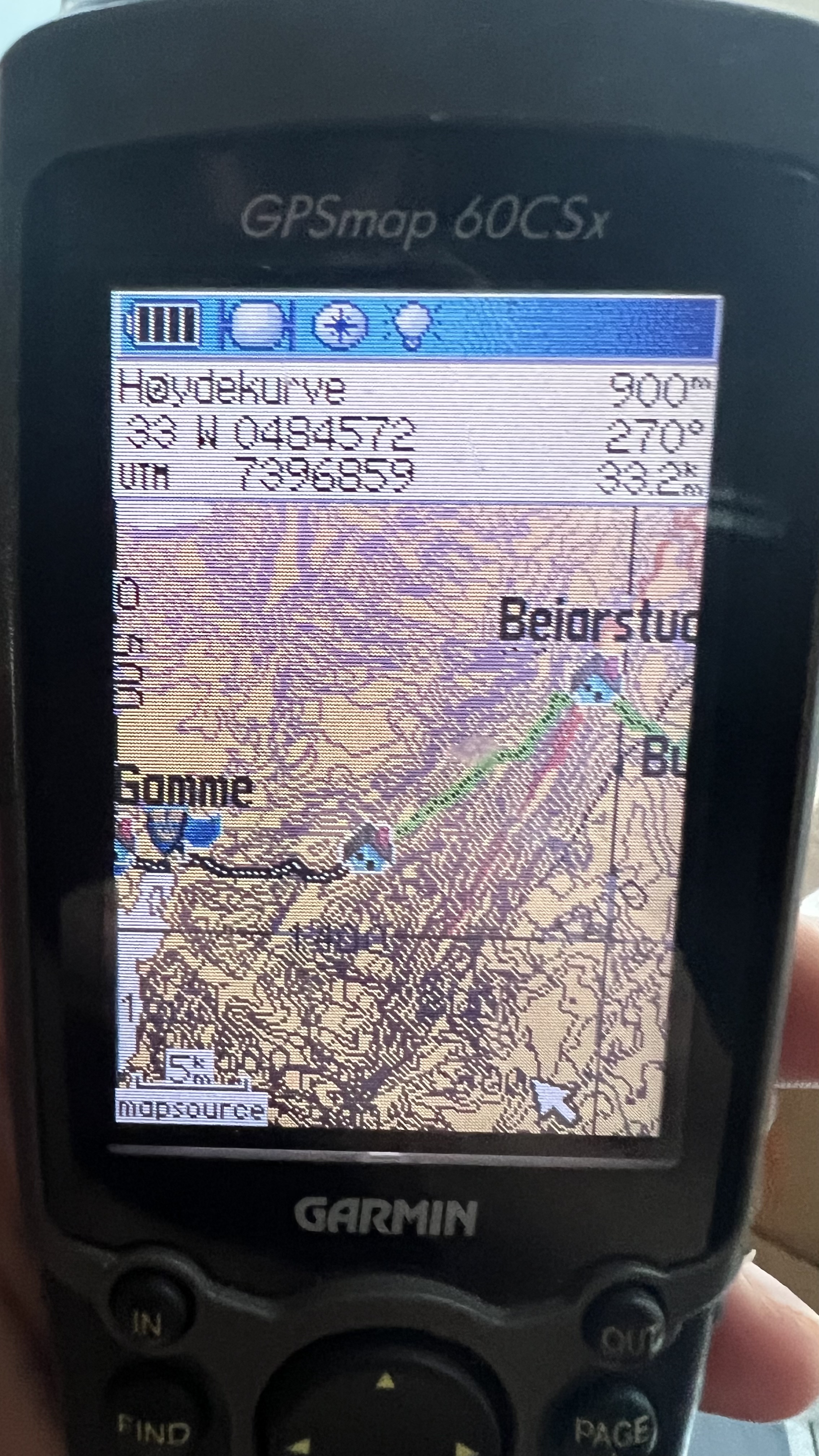
                @maszop ok, let’s try this one. The display of the Garmin csx76 is about 4.1 x 5.6 cm. Little bit bigger than the vertical. The vertical with its diameter of 4.9 cm is actually “wider” than the Garmin display. As you can see have i hiked in this area and it’s right around the corner where I live. I’m pretty familiar with the terrain. But what do you think? I zoomed out to 5 km as you can see. Would you say that this is a good example for an easy to read and user friendly map? Without knowing how the map would look like one the vertical, I assume that there would not be a such big difference if you have an area with lot of topography. In my opinion even a handhold gps isn’t optimal for some type of navigating but a good help when zooming in. As I said, when needing a overview in unknown terrain I like to use old fashioned topographic maps 😉

                Got the point?

                79B84931-7068-4539-A930-9F1AFA2C5AE0.jpeg

                Instagram: https://www.instagram.com/helgelandsbukken/
                https://www.instagram.com/suunto_adventures/
                IG: Helgelandsbukken, suunto_adventures
                Vimeo: vimeo.com/helgelandsbukken
                Blogg: https://turblogg.midnattsola.com

                M 1 Reply Last reply 4 Jul 2024, 23:18 Reply Quote 3
                • F Online
                  far-blue Bronze Member
                  last edited by 4 Jul 2024, 22:31

                  Maybe the suunto developers could just make the detail levels configurable. Then users can choose whether they want slower, information-dense maps or faster less-informative maps. In fact, the same user might wish to change the setting depending on where they are - up a creak without a paddle mountain without a paper map or somewhere more inhabited with other landmarks and recognisable trails / road.

                  1 Reply Last reply Reply Quote 2
                  • M Offline
                    maszop Bronze Member @Stefan Kersting
                    last edited by 4 Jul 2024, 23:18

                    @Stefan-Kersting You know, maybe I’ll refrain from commenting on your idiotic argument. (If I wrote what I think about it, I would have to be banned 😂)

                    One photo is enough to show that you (and a few others) have no idea what you are talking about.

                    image

                    B P S 3 Replies Last reply 4 Jul 2024, 23:36 Reply Quote -2
                    • B Offline
                      Brad_Olwin Moderator @maszop
                      last edited by 4 Jul 2024, 23:36

                      @maszop Don’t know your age but I was navigating with a map and compass when no consumer GPS existed or personal computers. I know what contour lines are and how to read a map. Would I like contour lines at all zoom levels? Sure, but it won’t prevent me from going into the mountains. I’d rather have contour lines as they are now than none at all, and I hope it will happen. I don’t set priorities at Suunto.
                      You however, need to tone your rhetoric down. Please do not insult individuals on the forum.

                      Vector/T6c/Ambit 3 Peak/S5 Copper/S3/S7 Ti/S9 baro Ti/S9P Ti/S9PP Ti/Vertical Ti/Race Ti/RaceS/Ocean/Wing

                      1 Reply Last reply Reply Quote 5
                      • D Offline
                        dreamer_ @maszop
                        last edited by dreamer_ 7 May 2024, 05:40 5 Jul 2024, 05:37

                        @maszop just for the quote. I’m not a walker, my sports are limited to trail running (most), marathons and long distance triathlons. I have never needed those lines because of my use cases and I also understand that you can need them because your use cases are different than mine. And that is fine, of course.
                        But here people are explaining the reasons of removing the lines.

                        If there’s a feature, and that’s for everything in computer science, that affects the usability of an application (maps) for the vast majority of people, and there’s no apparent easy fix, that feature is more a problem than a good thing. Suunto’s decision is the good one. Personally I don’t want those lines if the usability of the maps is going to be affected for those of us that uses the watch for trail running.

                        Btw, you know better than me that navigation is more than those lines. And Suunto has the best ABC sensors of the market, so it is not true at all what you say about the navigation with that “poorly” thing. Have a look here please: https://youtu.be/6JUS43kXgx4?si=3zWC9HT_as_IINlS

                        1 Reply Last reply Reply Quote 2
                        • D Offline
                          dreamer_ @dreamer_
                          last edited by 5 Jul 2024, 07:02

                          @dreamer_ said in What do you expect from the next update?:

                          The Step Counter seems fixed fixed for me. I need to test it better but, for now, it is not counting steps all time like it was before. Fantastic.

                          It seems broken. It is impossible to have more than 1400 steps at this moment in the morning (in one hour and half since I woke up)

                          3eaca453-ecf0-4358-92eb-9ef72e7fa9ae-image.png

                          Just to confirm that the soft reset worked. Today, waking up at the same time and walking the same distance I have a lot more realiable result at the same hour:

                          4d297bee-c366-40de-ae8e-b80112be1746-image.png

                          1 Reply Last reply Reply Quote 0
                          • P Offline
                            Prenj @maszop
                            last edited by 5 Jul 2024, 07:31

                            @maszop said in What do you expect from the next update?:

                            @Stefan-Kersting You know, maybe I’ll refrain from commenting on your idiotic argument. (If I wrote what I think about it, I would have to be banned 😂)

                            One photo is enough to show that you (and a few others) have no idea what you are talking about.

                            image

                            I don’t know how big an impact it would have on performance, but having contour lines at 500 m zoom would really make maps much much more useable in the mountains. I’d be fine with a bit slower interface to get this view.

                            Suunto Race

                            1 Reply Last reply Reply Quote 4
                            • I Offline
                              isazi Moderator @maszop
                              last edited by 5 Jul 2024, 07:48

                              @maszop said in What do you expect from the next update?:

                              I just don’t understand how you can write such nonsense over and over again.

                              Sure, I should have explained it better to have you understand it, but it is difficult when talking with a toddler 😄

                              Watch: Suunto Vertical Ti

                              Blog: isazi's home

                              1 Reply Last reply Reply Quote 1
                              • S Offline
                                Stefan Kersting @maszop
                                last edited by 5 Jul 2024, 10:42

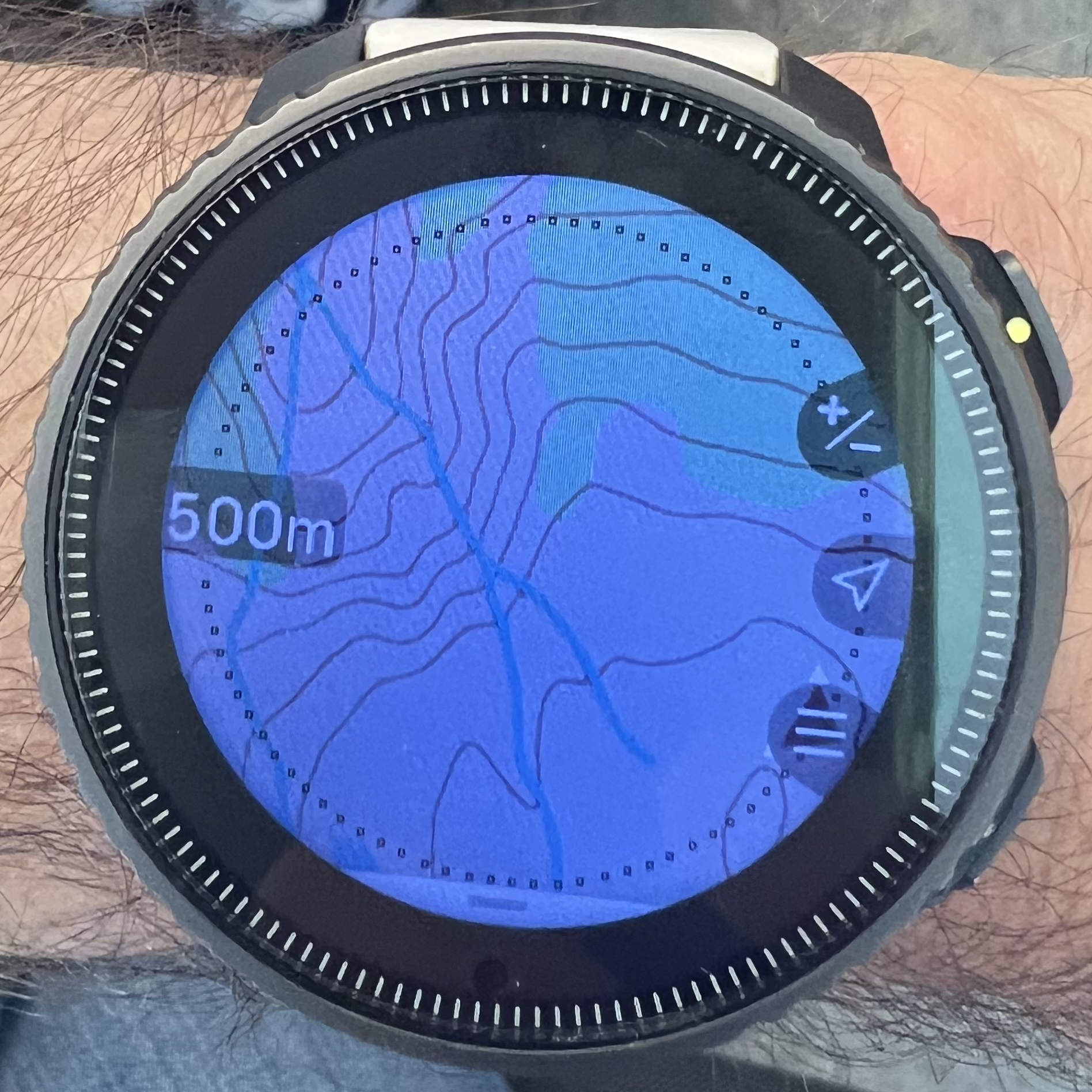
                                @maszop My map looks like this when using the 500 m scale. Isn’t that good enough?

                                B3A940E5-EADD-4ED1-9F7B-F1811822237C.jpeg

                                Instagram: https://www.instagram.com/helgelandsbukken/
                                https://www.instagram.com/suunto_adventures/
                                IG: Helgelandsbukken, suunto_adventures
                                Vimeo: vimeo.com/helgelandsbukken
                                Blogg: https://turblogg.midnattsola.com

                                I F M 3 Replies Last reply 5 Jul 2024, 10:52 Reply Quote 2
                                • I Offline
                                  Iggge @Stefan Kersting
                                  last edited by 5 Jul 2024, 10:52

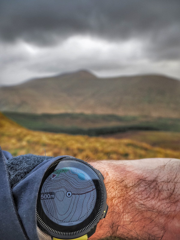
                                  @Stefan-Kersting mine look like this
                                  1000003381.jpg

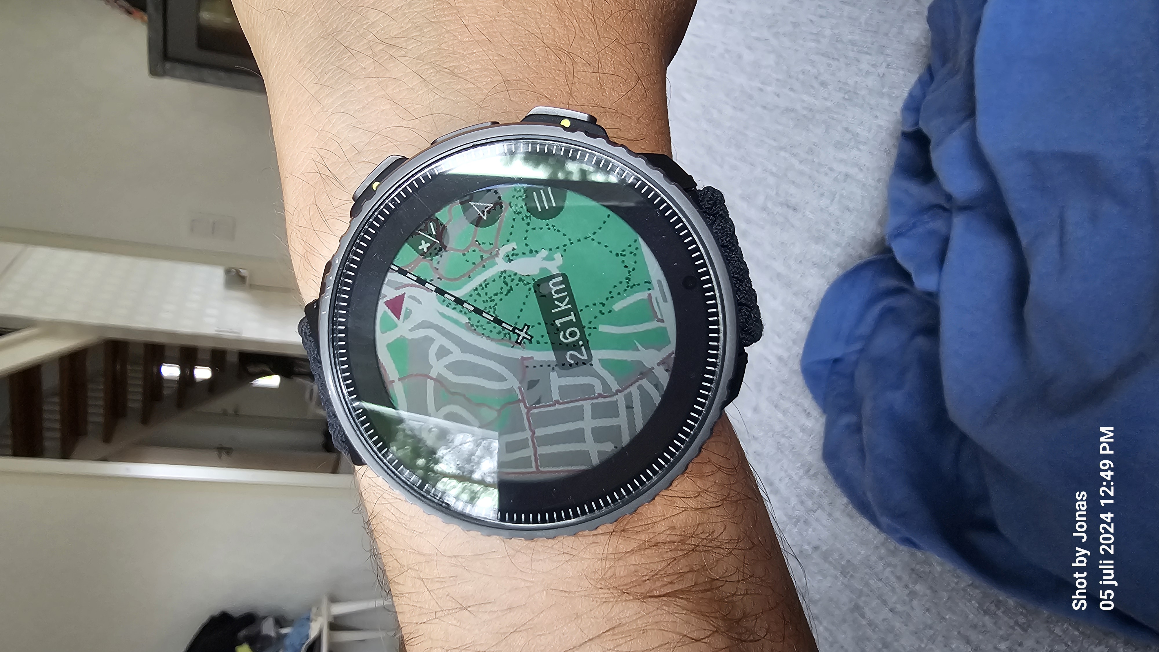
                                  And here are the same 200 m
                                  1000003382.jpg

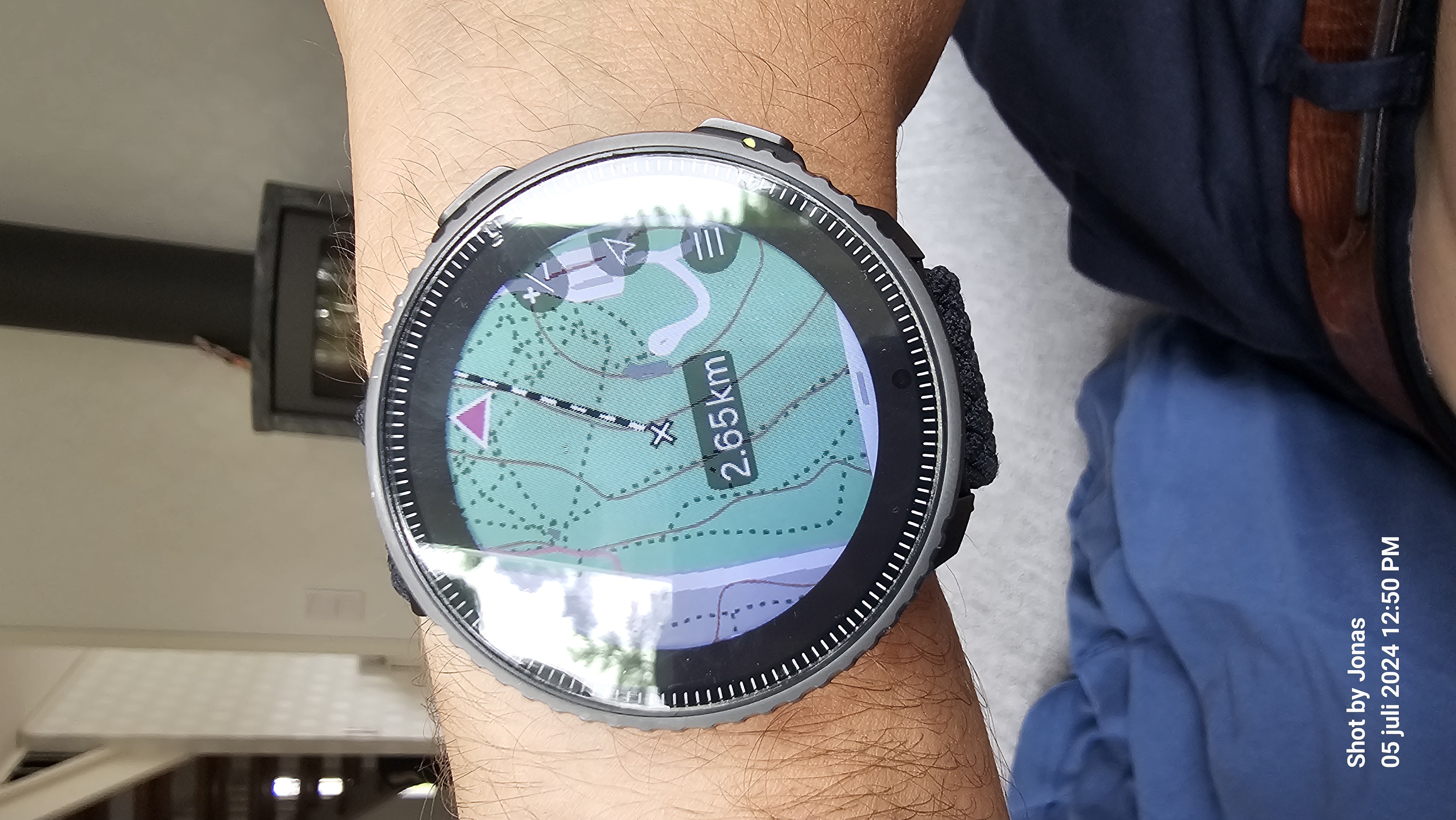
                                  During summer MTB riders use it for downhill, and winter it’s skiing.

                                  S 1 Reply Last reply 5 Jul 2024, 10:57 Reply Quote 1
                                  • S Offline
                                    Stefan Kersting @Iggge
                                    last edited by 5 Jul 2024, 10:57

                                    @Iggge for sure, it is depending of the topography and how steep it is. Using the watch for hiking, backcountry and MTB

                                    Instagram: https://www.instagram.com/helgelandsbukken/
                                    https://www.instagram.com/suunto_adventures/
                                    IG: Helgelandsbukken, suunto_adventures
                                    Vimeo: vimeo.com/helgelandsbukken
                                    Blogg: https://turblogg.midnattsola.com

                                    1 Reply Last reply Reply Quote 0
                                    • F Offline
                                      Fenr1r @Stefan Kersting
                                      last edited by 5 Jul 2024, 11:06

                                      @Stefan-Kersting “for sure, it is depending of the topography and how steep it is”.

                                      True, 'nuff. That doesn’t seem too cluttered to be returned to other maps. What is the contour separation shown in that 500m zoom pic?

                                      1 Reply Last reply Reply Quote 0
                                      • M Offline
                                        maszop Bronze Member @Stefan Kersting
                                        last edited by maszop 7 May 2024, 11:29 5 Jul 2024, 11:29

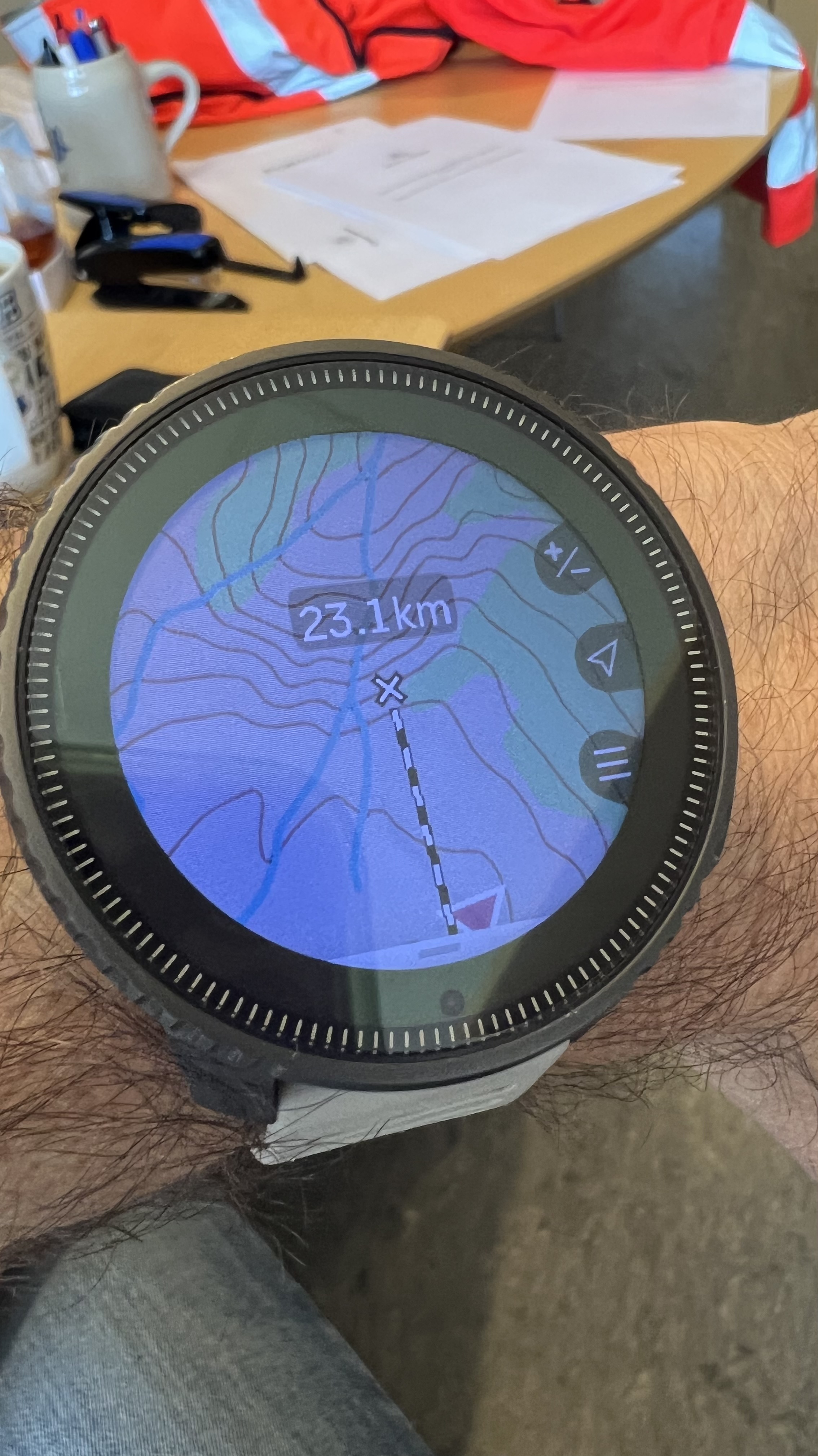
                                        @Stefan-Kersting This is not a 500m view because there are no contour lines in that view in Suunto anymore. The current maps in this case are just a gray background, like the breadcrumb from 9PP and earlier models.
                                        Turn off this useless ruler in this case and on the left you will have a number that symbolizes the zoom level. In my example, there is 500m from the older version of the maps, before the removal of these contours.

                                        S 1 Reply Last reply 5 Jul 2024, 11:36 Reply Quote -1
                                        • S Offline
                                          Stefan Kersting @maszop
                                          last edited by 5 Jul 2024, 11:36

                                          @maszop I like this ruler very much and don’t want to miss it 😀 so, I did as you said. I’m excited to hear what you’re saying now.

                                          398622D6-E15A-4CFE-8E05-A9E7F8594082.jpeg

                                          Instagram: https://www.instagram.com/helgelandsbukken/
                                          https://www.instagram.com/suunto_adventures/
                                          IG: Helgelandsbukken, suunto_adventures
                                          Vimeo: vimeo.com/helgelandsbukken
                                          Blogg: https://turblogg.midnattsola.com

                                          M 1 Reply Last reply 5 Jul 2024, 11:40 Reply Quote 3
                                          355 out of 615
                                          • First post
                                            355/615
                                            Last post

                                          Suunto Terms | Privacy Policy

                                            This community forum collects and processes your personal information.
                                            consent.not_received