Suunto app Forum Suunto Community Forum
    • Recent
    • Tags
    • Popular
    • Users
    • Groups
    • Register
    • Login

    What do you expect from the next update?

    Scheduled Pinned Locked Moved Suunto Vertical
    615 Posts 164 Posters 66.5k Views
    Loading More Posts
    • Oldest to Newest
    • Newest to Oldest
    • Most Votes
    Reply
    • Reply as topic
    Log in to reply
    This topic has been deleted. Only users with topic management privileges can see it.
    • EgikaE Offline
      Egika Platinum Member
      last edited by

      sometimes there are contour lines in the 500m zoom level.
      Had them myself when playing around with zoom levels for some time.
      maybe sometimes a 200m cached view is used when switching to 500m or so.

      t6, S6, Elementum Terra, Ambit 3 Sapphire, Spartan Ultra Copper, Traverse Alpha, S7 Graphite LE, S9B Ambassador, S9P Granite Blue Titanium, S9PP Titanium Sand, Vertical All Black, Race Titanium Charcoal,
      Race S All Black - TI Canary - Titanium Courtney

      M 1 Reply Last reply Reply Quote 1
      • M Offline
        maszop Bronze Member @Egika
        last edited by

        @Egika It looks like it was actually 200m. The view from 500m is a bit different.

        Stefan KerstingS 1 Reply Last reply Reply Quote 0
        • EgikaE Offline
          Egika Platinum Member
          last edited by

          whatever it looks like - there is a possibility to see contour lines at 500m zoom level.
          And yes - this is not the standard.
          and yes again: I’d be happy to see them back again for 500m zoom too

          t6, S6, Elementum Terra, Ambit 3 Sapphire, Spartan Ultra Copper, Traverse Alpha, S7 Graphite LE, S9B Ambassador, S9P Granite Blue Titanium, S9PP Titanium Sand, Vertical All Black, Race Titanium Charcoal,
          Race S All Black - TI Canary - Titanium Courtney

          1 Reply Last reply Reply Quote 5
          • Stefan KerstingS Offline
            Stefan Kersting @maszop
            last edited by Stefan Kersting

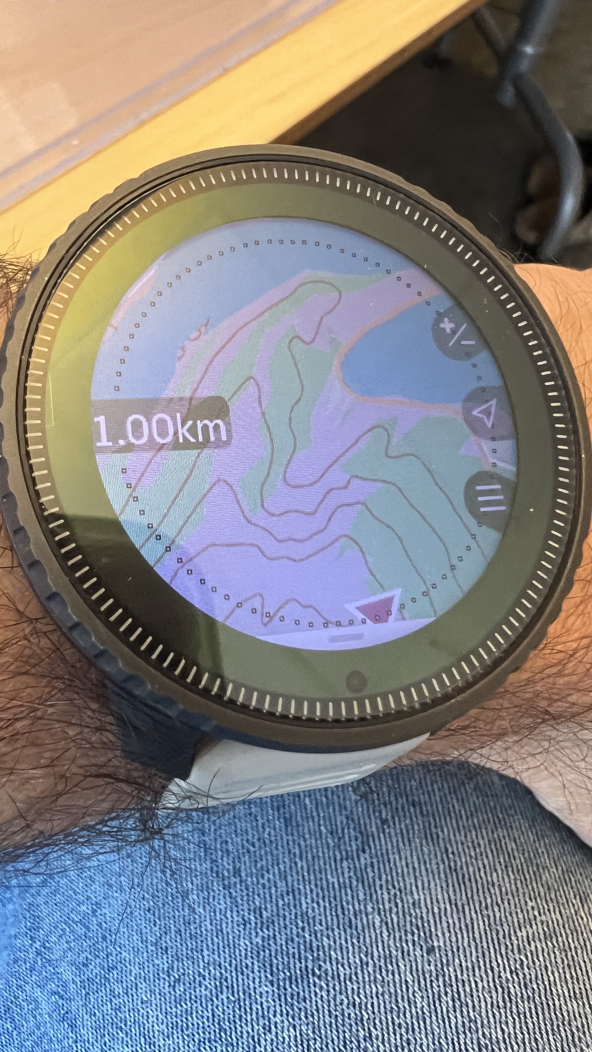
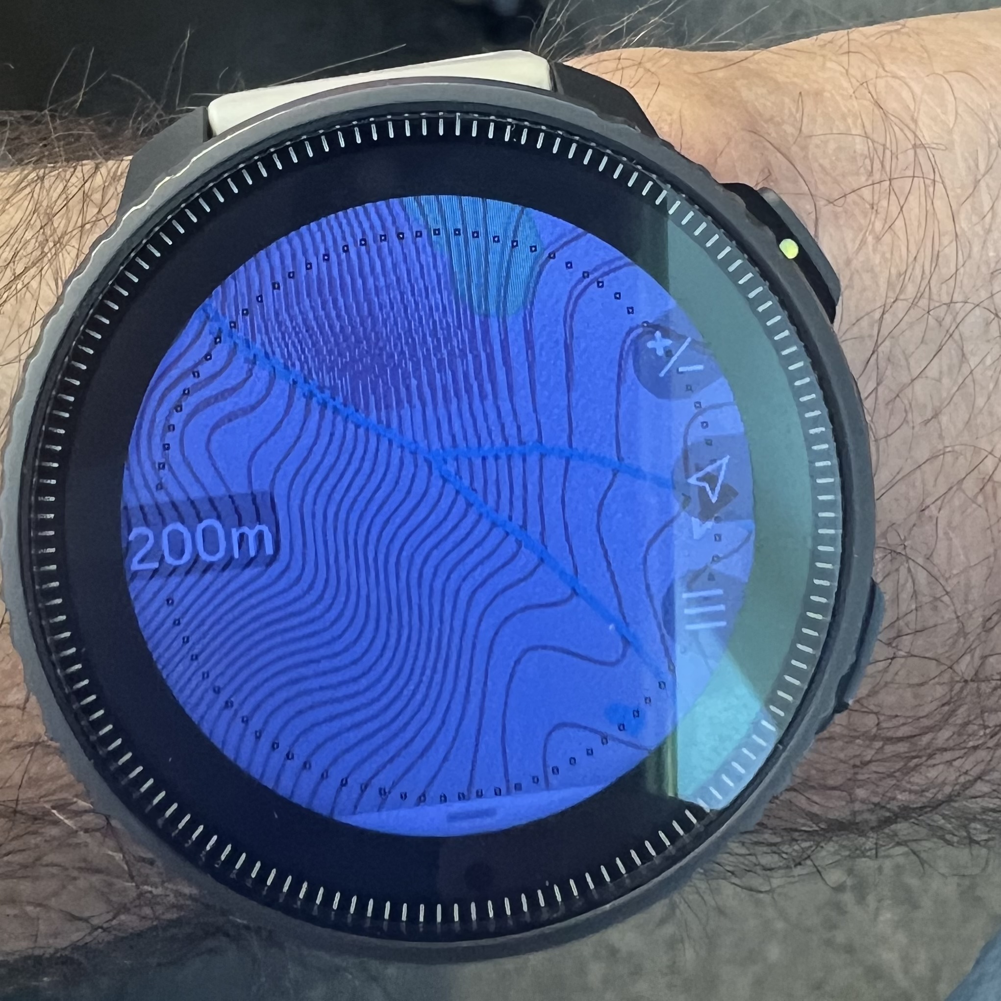
            @maszop all right, I did an effort and took a screenshot of the topo map for this area. See also the same area in 200 m scale.

            Skjermbilde.JPG

            AA4733C2-B9FF-44C4-8B57-5C61BD6C82DF.jpeg

            Instagram: https://www.instagram.com/helgelandsbukken/
            https://www.instagram.com/suunto_adventures/
            IG: Helgelandsbukken, suunto_adventures
            Vimeo: vimeo.com/helgelandsbukken
            Blogg: https://turblogg.midnattsola.com

            M 1 Reply Last reply Reply Quote 1
            • M Offline
              maszop Bronze Member @Stefan Kersting
              last edited by maszop

              @Stefan-Kersting Well, as you can see in this picture, 200 m is sometimes not enough in the mountains to properly see the terrain.
              With a view of 500m-1km do contour lines give a more clear image of the slope.

              Stefan KerstingS 1 Reply Last reply Reply Quote 1
              • Stefan KerstingS Offline
                Stefan Kersting @maszop
                last edited by Stefan Kersting

                @maszop no problem, as you can see I have the 500 m contour lines 😎 🤘 If you want I can show you the 1 km contour lines, too 🤓

                Instagram: https://www.instagram.com/helgelandsbukken/
                https://www.instagram.com/suunto_adventures/
                IG: Helgelandsbukken, suunto_adventures
                Vimeo: vimeo.com/helgelandsbukken
                Blogg: https://turblogg.midnattsola.com

                Fenr1rF 1 Reply Last reply Reply Quote 0
                • Fenr1rF Offline
                  Fenr1r @Stefan Kersting
                  last edited by

                  @Stefan-Kersting said in What do you expect from the next update?:

                  If you want I can show you the 1 km contour lines, too

                  Bring 'em on. Let’s see what’s possible.

                  Stefan KerstingS 1 Reply Last reply Reply Quote 0
                  • Stefan KerstingS Offline
                    Stefan Kersting @Fenr1r
                    last edited by

                    @Fenr1r @maszop here we go 😎🤘🏻

                    C2E984B2-F83F-491A-AE39-1997B669A197.jpeg

                    Instagram: https://www.instagram.com/helgelandsbukken/
                    https://www.instagram.com/suunto_adventures/
                    IG: Helgelandsbukken, suunto_adventures
                    Vimeo: vimeo.com/helgelandsbukken
                    Blogg: https://turblogg.midnattsola.com

                    M Fenr1rF 2 Replies Last reply Reply Quote 3
                    • M Offline
                      maszop Bronze Member @Stefan Kersting
                      last edited by maszop

                      @Stefan-Kersting It was like that until December (until “temporary” removal). I myself have some older maps with contour lines that I simply haven’t updated. Which was visible in my earlier photo.

                      As you can see, they are very clear and readable and it is logical that there is something to complain about.

                      1 Reply Last reply Reply Quote 1
                      • Fenr1rF Offline
                        Fenr1r @Stefan Kersting
                        last edited by

                        @Stefan-Kersting Grrrrgh. Is KOMO (Knowledge Of Missing Out) a thing?

                        Thanks.

                        Do you have other Norwegian map areas downloaded, also with 1km zoom?

                        I’m wondering what Suunto’s map detail criteria are.

                        Stefan KerstingS 1 Reply Last reply Reply Quote 0
                        • Stefan KerstingS Offline
                          Stefan Kersting @Fenr1r
                          last edited by

                          @Fenr1r just Nordland, Troms and Finnmark

                          Instagram: https://www.instagram.com/helgelandsbukken/
                          https://www.instagram.com/suunto_adventures/
                          IG: Helgelandsbukken, suunto_adventures
                          Vimeo: vimeo.com/helgelandsbukken
                          Blogg: https://turblogg.midnattsola.com

                          1 Reply Last reply Reply Quote 0
                          • Todd DanielczykT Offline
                            Todd Danielczyk Gold Members @Stefan Kersting
                            last edited by

                            @Stefan-Kersting said in What do you expect from the next update?:

                            …When on a hike and several days in the mountains you have to use a old school map…

                            geologist has entered the chat

                            This is 100% accurate. I love the fact the maps can zoom out now and if I’m in back country I WOULD NEVER be without a paper map and compass. The mapping on the watch would always be in addition to, never a full replacement.

                            Redundancy is key to survival.

                            Stefan KerstingS 1 Reply Last reply Reply Quote 10
                            • Stefan KerstingS Offline
                              Stefan Kersting @Todd Danielczyk
                              last edited by

                              @Todd-Danielczyk how many likes is it possible to give on this response 👍🏻😀 best regards, geographer 😀

                              Instagram: https://www.instagram.com/helgelandsbukken/
                              https://www.instagram.com/suunto_adventures/
                              IG: Helgelandsbukken, suunto_adventures
                              Vimeo: vimeo.com/helgelandsbukken
                              Blogg: https://turblogg.midnattsola.com

                              Todd DanielczykT 1 Reply Last reply Reply Quote 1
                              • Todd DanielczykT Offline
                                Todd Danielczyk Gold Members @Stefan Kersting
                                last edited by

                                @Stefan-Kersting said in What do you expect from the next update?:

                                @Todd-Danielczyk how many likes is it possible to give on this response 👍🏻😀 best regards, geographer 😀

                                See, I knew I liked you for a reason!

                                Our backgrounds require us to be friends🤣 (but I also really love the photos you take and your EPIC adventures, so there is that!)

                                Stefan KerstingS 1 Reply Last reply Reply Quote 1
                                • Stefan KerstingS Offline
                                  Stefan Kersting @Todd Danielczyk
                                  last edited by

                                  @Todd-Danielczyk little bit off topic 😅 with passion for geosciences and maps 😄

                                  Instagram: https://www.instagram.com/helgelandsbukken/
                                  https://www.instagram.com/suunto_adventures/
                                  IG: Helgelandsbukken, suunto_adventures
                                  Vimeo: vimeo.com/helgelandsbukken
                                  Blogg: https://turblogg.midnattsola.com

                                  1 Reply Last reply Reply Quote 2
                                  • S Offline
                                    slurpnik
                                    last edited by

                                    I was out in Chamonix this week and missed this conversation on contour lines - luckily I have an example to contribute 😊

                                    This week I climbed Mont Blanc via Trois Monts route. We left Cosmiques 1am for a nice early alpine start, conditions were great. On the slope of Mont Maudit though, we went up little more to the left in the direction of the peak, not the col. I checked the watch, realized we’re probably steering way too much to the left and after short discussion we corrected. Yay, points for Vertical!

                                    …except it was not so easy. At 200m zoom level all I saw was that we’re in the middle of the slope. At 500m all I saw was a dotted line from OSM where the route likely goes, and that we’re somewhat to the left of it. As everyone knows, navigating on glaciated slope in this exact situation by blindly following a breadcrumb trail is very stupid and a sure path to danger, so I was not keen to make many decisions based on it.

                                    If there were contour lines at 500m zoom, it would have been a two second glance on the watch to realize where the peak is and where the col is given contour lines. That’s really what I feel everyone is asking for in terms of user experience from an adventure watch. Instead it was faff to figure it out.

                                    @Stefan-Kersting some maps still have those contour lines at higher zoom levels - I’ve seen it myself. I am very happy for you that you have them for maps you care about, but vast majority of the maps don’t. I also think those of us who’ve experienced contours at 500m saw that responsiveness of the UI with contour is not much of an issue (mine were fairly usable at 2km zoom as well, which is unnecessary TBH).

                                    @dreamer_ I agree with your arguments. I would propose that contour lines at higher zoom levels on the adventure watch - Vertical (accepting less responsive UI if that’s the price), and no contour lines with super responsive maps for the trail running watch - Race - would make the most sense. However I understand how negatively that division might be viewed, but IMHO trail running usecases are limiting the potential of SV.

                                    Watch: Suunto Vertical (titanium solar canyon)

                                    Fenr1rF 1 Reply Last reply Reply Quote 12
                                    • Fenr1rF Offline
                                      Fenr1r @slurpnik
                                      last edited by

                                      @slurpnik Very well put.

                                      1 Reply Last reply Reply Quote 2
                                      • tom-peleT Offline
                                        tom-pele
                                        last edited by

                                        Perhaps a new widget with tidal forecast , in respect within You’re location
                                        24 hour forecast

                                        Br.

                                        1 Reply Last reply Reply Quote 4
                                        • gerasimosG Offline
                                          gerasimos Bronze Member
                                          last edited by gerasimos

                                          -Widget with routes
                                          -not pop up messages in nav mode

                                          • tooth navigation customize "tap"on the fly (ETA - ETE - pace - etch )
                                          • mirroring route in real time with SUUNTO app

                                          Suunto Vertical Ti
                                          Suunto S9 gen1
                                          Suunto Ambit3 peak

                                          1 Reply Last reply Reply Quote 2
                                          • Mister PYCM Offline
                                            Mister PYC Silver Members @Stefan Kersting
                                            last edited by

                                            @Stefan-Kersting Hello Stefan I think we are perfectly aligned
                                            See my post : https://forum.suunto.com/topic/11310/valuate-the-x-on-the-map-and-offer-the-possibility-to-save-it-as-a-poi-or-to-go-to-it-in-bearing-mode/2?_=1722932936286
                                            and do tell me if it was your idea also

                                            Suunto offer the possibility to visualize the distance and the angle so direction from the map, why not to have an option to decide that this is the bearing direction and to point the compass to it ???

                                            All is possible in IT
                                            Driven by you fear you stay on the ground, driven by your dreams you fly

                                            V 1 Reply Last reply Reply Quote 1
                                            • First post
                                              Last post

                                            Suunto Terms | Privacy Policy