Improving navigation further after 2.35 update
-
As for Climb Guidance (can we call it CG?), when it works, it seems to work well. But several times in the past few days of use, it has simply failed to either register a climb/uphill or inverted an uphill for a downhill or vice versa. Here’s an example from today’s run:
First, the overall elevation view after beginning the biggest climb of the route:
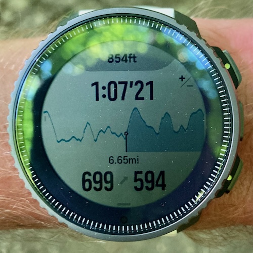
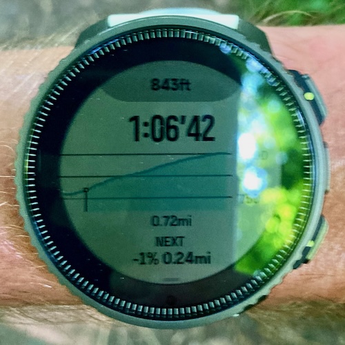
Here’s the zoomed in view, registering as a flat blue section (clearly doesn’t look like it):
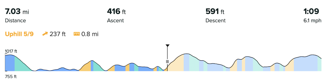
Here’s the profile from SA where it’s clearly labelled an uphill section:
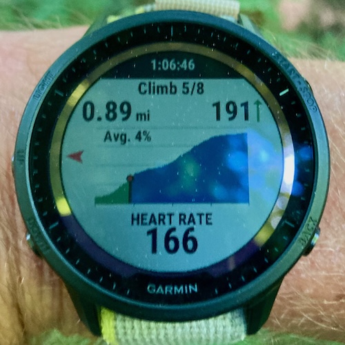
And, for good measure, the ClimbPro screen running on my 955 at the same time:
So what happened? It’s correctly marked in SA, so why did it disappear on the watch? There are clearly some holes in the system that need to be patched.
The other issue I’m seeing is with the ascent/descent calculations for the sections. They seem to be anywhere from 20-30% shy of reality. I’m sure this has more to do with the background elevation data used in SA. For my region, at least, it is quite far off. Or perhaps not as “granular” as the data I see from others like Garmin.
Vertical Ti / S9PP Ti / S9P Ti
-
@duffman19 said in Improving navigation further after 2.35 update:
As for Climb Guidance (can we call it CG?), when it works, it seems to work well. But several times in the past few days of use, it has simply failed to either register a climb/uphill or inverted an uphill for a downhill or vice versa. Here’s an example from today’s run:
-
@duffman19 It indeed depends on the underlying data. And you will only get notifications about the Climb sections, not Uphills. From the profile it looks like there are no Climbs at all on your route.
-
@kriskus I was not referring to notifications, which, yes, are only triggered by climbs and descents. Any and all types of sections are displayed when you zoom in on the elevation graph. So for most of the other uphill sections on my run, the watch correctly displayed the uphill graphics labelled in orange with the remaining ascent value. For some reason, it completely missed the largest climb (as I tried to show above), instead labelling it a flat section in light blue.
-
@duffman19 OK, got it. Strange then…
-
Don’t know if this fits in here. I rather often get lost on trails when using turn by turn navigation and there are e.g. 4 trails going off and the watch say just in x meters / feet - right but I had to take the second one.
I have a PP9, so no map to look at.
Planing is done with Komoot, cause when using the Suunto app I was getting a massive number of trurns that didn’t even exist.I don’t know if this is possible somehow, because it is just only some gpx data, to say right in x meters / feet but show on the watch that there are still 2or 3 other trails.
Another great feature for turn by turn would be text to speech like it happens wiht heartrates, time and so on. I often have my headsets on when using komoot or even google for navigation, this works faster for me than looking on the watch.
An one last but I guess it won’t come - maps for the 9pp
")
-
@Ecki-D the only subtlety here is the “sharp/slight” left/right that exists at such trail heads, or left/right fork. It does exist at road roundabouts where exits are specified but not in the same vein for trails.
Also this has been requested before with an elegant sketch of how it looks but I can’t remember from who or when.
-
@The_77 Yeah I have seen that roundabout thing. Thought about a sketch but if there is one already even better.
-
Adding functionality to lock the map ”north up” and spin the arrow showing your location instead would be really great. Can be really confusing with a spinning map when taking a brief glance at the map. Also when scrolling through the map it’s really annoying when the map spins as soon as you turn your arm a little in my opinion.
Should also be easier on data processing needs for showing the map i guess. -
@maxll Yes. For example, Garmin recommend for battery savings to use North Up not Track up, and so I’d imagine that this would help a lot as it would reduce map redraws
-
@maxll Was suggested here as well
https://forum.suunto.com/post/146463 -
D duffman19 referenced this topic on